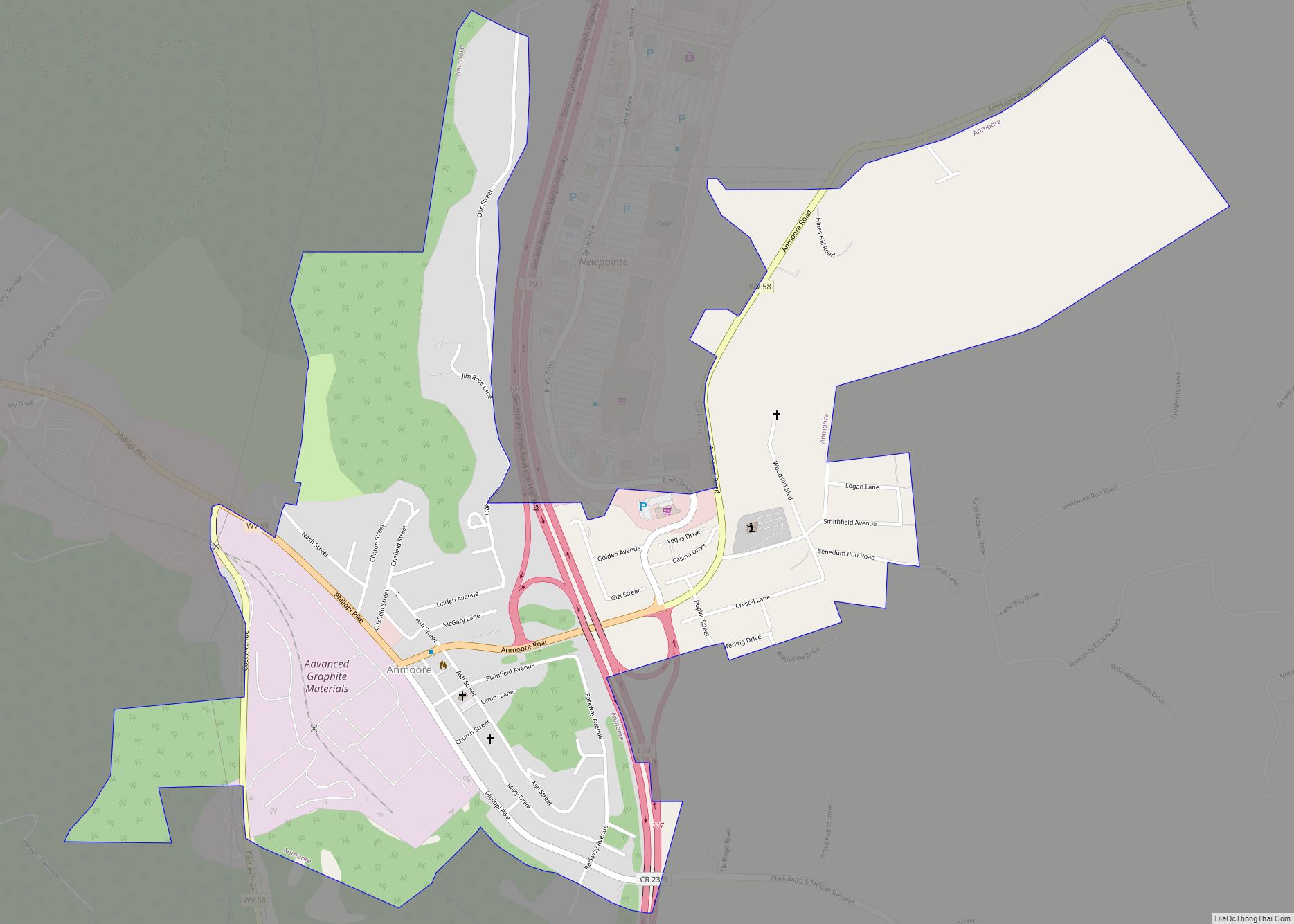
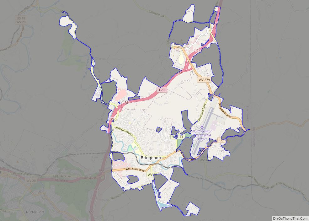
Map of Alum Creek CDP
Alum Creek is a census-designated place (CDP) in Kanawha and Lincoln counties along the Coal River in the U.S. state of West Virginia. It includes the unincorporated communities of Alum Creek, Forks of Coal, and Priestley. The CDP had a population of 1,749 at the 2010 census, down from 1,839 at the 2000 census. The ... Read more
Map of Alum Creek CDP
Map of Barrackville town
Barrackville is a town in Marion County, West Virginia, United States. The population was 1,211 at the 2020 census. Barrackville was settled beginning in 1767 by William Galloway “Indian Billy” Ice. The town was named in honor of John Barrack, an early settler. It was incorporated January 25, 1968. Barrackville town overview: Name: Barrackville town ... Read more
Map of Barrackville town
Map of Berwind CDP
Berwind is a town on the Dry Fork in McDowell County, West Virginia, United States. As of the 2010 census, its population is 278. The town is named for Edward Julius Berwind, owner of the Berwind Company, and was originally a company town. It was later incorporated in 1905. Berwind is the hometown of Vern ... Read more
Map of Berwind CDP
Map of Benwood city
Benwood is a city in Marshall County, West Virginia, United States, along the Ohio River. It is part of the Wheeling, West Virginia Metropolitan Statistical Area. The population was 1,269 at the 2020 census. Benwood was chartered in 1853 and incorporated in 1895. The name of the city is derived from “Ben’s Woods”, as Benjamin ... Read more
Map of Benwood city
Map of Belle town, West Virginia
Belle is a town in Kanawha County, West Virginia, United States, situated along the Kanawha River. The population was 1,171 at the 2020 census. Belle was incorporated on December 13, 1958 by the Kanawha County Circuit Court. It is the home of the Belle Bulldogs Elementary School. Belle Reynolds, an early postmaster, gave the town ... Read more
Map of Belle town, West Virginia
Map of Beckley city
Beckley is a city in and the county seat of Raleigh County, West Virginia, United States. The population was 17,286 at the 2020 census, making it the ninth-largest city in the state. It is the principal city of the Beckley metropolitan area of Southern West Virginia, home to 115,079 residents in 2020. Beckley was founded ... Read more
Map of Beckley city
Map of Beverly town, West Virginia
Beverly is a town in Randolph County, West Virginia, United States. Founded in 1787, it is the oldest settlement in the Tygart River Valley. It had a population of 628 at the 2020 census. Beverly was the county seat of Randolph County for over a century—from 1790 until 1899—after which the nearby settlement of Elkins ... Read more
Map of Beverly town, West Virginia
Map of Bartow CDP, West Virginia
Bartow is a census-designated place (CDP) in Pocahontas County, West Virginia, United States. The population was 111 at the 2010 census. Bartow is situated along U.S. Route 250 and West Virginia Route 92 and on the East Fork Greenbrier River, approximately 2 miles (3.2 km) east of Durbin. It has a post office with ZIP code ... Read more
Map of Bartow CDP, West Virginia
Map of Bartley CDP, West Virginia
Bartley is a census-designated place (CDP) located in McDowell County, West Virginia, United States. It lies along the Norfolk and Western Railroad on the Dry Fork. As of the 2010 census, its population was 224. According to the Geographic Names Information System, Bartley has also been known as Bartlett and Peeryville. Bartley CDP overview: Name: ... Read more
Map of Bartley CDP, West Virginia
Map of Bradley CDP, West Virginia
Bradley is a census-designated place (CDP) in Raleigh County, West Virginia, United States, named in honor of General Omar Bradley, a field commander in North Africa and Europe during World War II and a General of the Army. The population was 2,040 at the 2010 census. Bradley CDP overview: Name: Bradley CDP LSAD Code: 57 ... Read more
Map of Bradley CDP, West Virginia
Map of Bowden CDP
Bowden is a census-designated place (CDP) in Randolph County, West Virginia, United States. Bowden is located on U.S. Route 33, 7.5 miles (12.1 km) east of Elkins. Bowden has a post office with ZIP code 26254. According to the 2010 Census, there were nine people residing at this location. Bowden CDP overview: Name: Bowden CDP LSAD ... Read more
Map of Bowden CDP
Map of Boomer CDP
Boomer is a census-designated place (CDP) in Fayette County, West Virginia, United States. Boomer is located on the north bank of the Kanawha River, 2 miles (3.2 km) southeast of Smithers. Boomer has a post office with ZIP code 25031. As of the 2010 census, its population was 615. Boomer CDP overview: Name: Boomer CDP LSAD ... Read more
Map of Boomer CDP