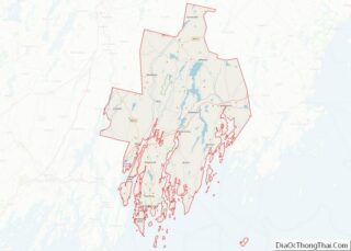
Map of Jasper County, Missouri
Coordinates: 37°12′N 94°20′W / 37.20°N 94.34°W / 37.20; -94.34 Jasper County is located in the southwest portion of the U.S. state of Missouri. As of the 2020 census, the population was 122,761. Its county seat is Carthage, and its largest city is Joplin. The county was organized in 1841 and named for William Jasper, a ... Read more
Map of Jasper County, Missouri
Map of Mercer County, Missouri
Mercer County is a county located in the northwestern portion of the U.S. state of Missouri. As of the 2020 census, the population was 3,538. making it the second-least populous county in Missouri. Its county seat is Princeton. The county was organized February 14, 1845 and named for General John F. Mercer of the Revolutionary ... Read more
Map of Mercer County, Missouri
Map of Phelps County, Missouri
Phelps County overview: Name: Phelps County FIPS code: 29-161 State: Missouri Founded: 13 November 1857 Named for: John S. Phelps Seat: Rolla Largest city: Rolla Total Area: 674 sq mi (1,750 km²) Land Area: 672 sq mi (1,740 km²) Total Population: 44,638 Population Density: 66/sq mi (26/km²) Time zone: UTC−6 (Central) Summer Time Zone (DST): UTC−5 (CDT) Website: www.phelpscounty.org Phelps County location ... Read more
Map of Phelps County, Missouri
Map of Saline County, Missouri
Saline County is located along the Missouri River in the U.S. state of Missouri. As of the 2010 census, the population was 23,370. Its county seat is Marshall. The county was established November 25, 1820, and named for the region’s salt springs. Settled primarily by migrants from the Upper South during the nineteenth century, this ... Read more
Map of Saline County, Missouri
Map of Worth County, Missouri
Worth County is a county located in the northwestern portion of the U.S. state of Missouri. As of the 2020 census, the population was 1,973. It is the smallest county in the state in population and, excluding the independent city of St. Louis, the smallest in total area. Its county seat is Grant City. The ... Read more
Map of Worth County, Missouri
Map of Flathead County, Montana
Flathead County is in the U.S. state of Montana. At the 2020 census, its population was 104,357, making it the state’s fourth most populous county. Its county seat is Kalispell. Its numerical designation (used in the issuance of license plates) is 7. Its northern border is on the state’s north border, making it contiguous with ... Read more
Map of Flathead County, Montana
Map of Mineral County, Montana
Mineral County is a county located in the U.S. state of Montana. As of the 2020 census, the population was 4,535. Its county seat is Superior. Mineral County overview: Name: Mineral County FIPS code: 30-061 State: Montana Founded: 1914 Seat: Superior Largest town: Superior Total Area: 1,223 sq mi (3,170 km²) Land Area: 1,219 sq mi (3,160 km²) Total Population: 4,535 ... Read more
Map of Mineral County, Montana
Map of Silver Bow County, Montana
Silver Bow County is a county in the U.S. state of Montana. As of the 2020 census, the population was 35,133. Its county seat is Butte. In 1977, the city and county governments consolidated to form the single entity of Butte-Silver Bow. Additionally, the town of Walkerville is a separate municipality from Butte and is ... Read more
Map of Silver Bow County, Montana
Map of Box Butte County, Nebraska
Box Butte County overview: Name: Box Butte County FIPS code: 31-013 State: Nebraska Founded: 1886 Seat: Alliance Largest city: Alliance Total Area: 1,078 sq mi (2,790 km²) Land Area: 1,075 sq mi (2,780 km²) Total Population: 10,604 Population Density: 10.1/sq mi (3.9/km²) Time zone: UTC−7 (Mountain) Summer Time Zone (DST): UTC−6 (MDT) Website: boxbuttecounty.us Box Butte County location map. Where is Box ... Read more
Map of Box Butte County, Nebraska
Map of Dawes County, Nebraska
Dawes County is a county in the U.S. state of Nebraska. As of the 2010 United States Census, the population was 9,182. Its county seat is Chadron. The county was formed in 1885; it was named for James W. Dawes, the Nebraska Governor at the time. In the Nebraska license-plate system, Dawes County is represented ... Read more
Map of Dawes County, Nebraska
Map of Greeley County, Nebraska
Greeley County is a county in the U.S. state of Nebraska. As of the 2010 census, the population was 2,538. Its county seat is Greeley. In the Nebraska license plate system, Greeley County is represented by the prefix 62 (it had the 62nd-largest number of vehicles registered in the county when the license plate system ... Read more
Map of Greeley County, Nebraska
Map of Lancaster County, Nebraska
Lancaster County is a county located in the U.S. state of Nebraska. As of the 2020 United States Census, the population was 322,608, making it the second-most populous county in Nebraska. Its county seat is Lincoln, the state capital. The county was created in 1859. Lancaster County is part of the Lincoln, NE Metropolitan Statistical ... Read more
Map of Lancaster County, Nebraska