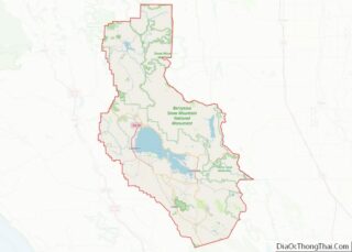
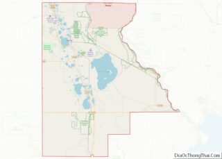
Franklin County is a county in Southern Illinois. At the 2020 census, it had a population of 37,804. The largest city is West Frankfort and the county seat is Benton. This area of Southern Illinois is known locally as “Little Egypt”. Franklin County overview: Name: Franklin County FIPS code: 17-055 State: Illinois Founded: January 2, ... Read more
Map of US Counties
Johnson County is a county in the U.S. state of Illinois. According to the 2010 census, it has a population of 12,582. Its county seat is Vienna. It is located in the southern portion of Illinois known locally as “Little Egypt”. Johnson County overview: Name: Johnson County FIPS code: 17-087 State: Illinois Founded: 1812 Named ... Read more
Marshall County is a county located in the U.S. state of Illinois. According to the 2010 census, it had a population of 12,640. Its county seat is Lacon. Marshall County is part of the Peoria, IL Metropolitan Statistical Area. Marshall County overview: Name: Marshall County FIPS code: 17-123 State: Illinois Founded: January 19, 1839 Named ... Read more
Pike County is a county in the U.S. state of Illinois. It is located between the Mississippi River and the Illinois River in western Illinois. According to the 2010 United States Census, it had a population of 16,430. Its county seat is Pittsfield. Pike County overview: Name: Pike County FIPS code: 17-149 State: Illinois Founded: ... Read more
Union County is a county located in the U.S. state of Illinois. According to the 2020 United States Census, it had a population of 17,244. Its county seat is Jonesboro. It is located in the southern portion of Illinois known locally as “Little Egypt”. Union County overview: Name: Union County FIPS code: 17-181 State: Illinois ... Read more
Blackford County is located in the east central portion of the U.S. state of Indiana. The county is named for Judge Isaac Blackford, who was the first speaker of the Indiana General Assembly and a long-time chief justice of the Indiana Supreme Court. Created in 1838, Blackford County is divided into four townships, and its ... Read more
Fayette County overview: Name: Fayette County FIPS code: 18-041 State: Indiana Founded: 1819 Named for: Marquis de la Fayette Seat: Connersville Largest city: Connersville Total Area: 215.16 sq mi (557.3 km²) Land Area: 215.01 sq mi (556.9 km²) Total Population: 23,398 Population Density: 113/sq mi (43.61/km²) Fayette County location map. Where is Fayette County? History The county and its seat Connersville rose ... Read more
Jasper County is a county located in the U.S. state of Indiana. As of 2010, the population was 33,478. The county seat is Rensselaer. Jasper County is included in the Chicago-Naperville–Elgin, IL-IN-WI Metropolitan Statistical Area. Jasper County overview: Name: Jasper County FIPS code: 18-073 State: Indiana Named for: Sgt. William Jasper Largest city: Rensselaer Land ... Read more
Miami County is a county located in the U.S. state of Indiana. As of 2020, the population was 35,962. The county seat is the City of Peru. Miami County is part of the Kokomo-Peru CSA. Miami County overview: Name: Miami County FIPS code: 18-103 State: Indiana Founded: January 30, 1833 Named for: Miami tribe Seat: ... Read more
Randolph County is a county located in the central section of U.S. state of Indiana, on its eastern border with Ohio. As of 2010, the population was 26,171. The county seat is Winchester. Randolph County overview: Name: Randolph County FIPS code: 18-135 State: Indiana Founded: 1818 Named for: Peyton Randolph Seat: Winchester Largest city: Winchester ... Read more
Vigo County (/ˈviːɡoʊ/ VEE-goh) is a county on the western border of the U.S. state of Indiana. According to the 2020 United States Census, it had a population of 105,994. Its county seat is Terre Haute. Vigo County is included in the Terre Haute metropolitan area. The county contains four incorporated settlements with a total ... Read more
Boone County is a county in the U.S. state of Iowa. As of the 2020 census, the population was 26,715. Its county seat is Boone. Boone County comprises the Boone, IA Micropolitan Statistical Area, which is included in the Des Moines–Ames–West Des Moines, IA Combined Statistical Area. Boone County overview: Name: Boone County FIPS code: ... Read more