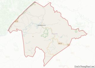
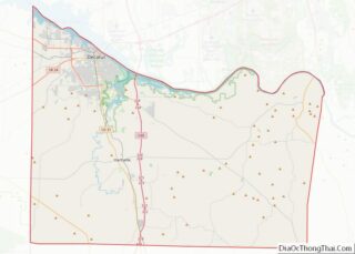
Wyandotte County (/ˈwaɪ.əndɒt/; county code WY) is a county in the U.S. state of Kansas. As of the 2020 census, the population was 169,245, making it Kansas’s fourth-most populous county. Its county seat and most populous city is Kansas City, with which it shares a unified government. Wyandotte County also includes the city of Bonner ... Read more
Map of US Counties
Butler County is a county located in the US state of Kentucky. As of the 2020 Census, the population was 12,371. Its county seat is Morgantown. The county was formed in 1810, becoming Kentucky’s 53rd county. Butler County is included in the Bowling Green, Kentucky, Metropolitan Statistical Area. Butler County overview: Name: Butler County FIPS ... Read more
Elliott County is a county located in the U.S. state of Kentucky. Its county seat is Sandy Hook. The county was formed in 1869 from parts of Morgan, Lawrence, and Carter counties, and is named for John Lyle Elliott, U.S. Congressman, Confederate Justice of the Kentucky Court of Appeals. In regard to alcohol sales, Elliott ... Read more
Harlan County is a county located in southeastern Kentucky. As of the 2020 census, the population was 26,831. Its county seat is Harlan. It is classified as a moist county—a county in which alcohol sales are prohibited (a dry county), but containing a “wet” city, in this case Cumberland, where package alcohol sales are allowed. ... Read more
Lawrence County is a county located in the U.S. state of Kentucky. As of the 2020 census, the population was 16,293. Its county seat is Louisa. The county is named for James Lawrence, and co-founded by Isaac Bolt, who served as a Lawrence County Commissioner and Justice of the Peace. Lawrence County is the home ... Read more
McCreary County is a county located in the U.S. state of Kentucky. As of the 2020 census, the population was 16,888. Its county seat is Whitley City. The county is named for James B. McCreary, a Confederate war soldier and two-time Governor of Kentucky (1875–1879, 1911–1915). During his second term as governor, McCreary County was ... Read more
Pendleton County is a county located in the U.S. state of Kentucky. As of the 2020 census, the population was 14,644. Its county seat is Falmouth. The county was founded December 13, 1798. Pendleton County is included in the Cincinnati-Middletown, OH-KY-IN Metropolitan Statistical Area. Pendleton County overview: Name: Pendleton County FIPS code: 21-191 State: Kentucky ... Read more
Trimble County is a county located in the north central part of the U.S. state of Kentucky. Its county seat is Bedford. The county was founded in 1837 and is named for Robert Trimble. Trimble is no longer a prohibition or dry county. Trimble County is part of the Louisville/Jefferson County, KY–IN Metropolitan Statistical Area. ... Read more
Bossier Parish (/ˈboʊʒər/ BOH-zhər; French: Paroisse de Bossier) is a parish located in the northwestern part of the U.S. state of Louisiana. At the 2020 census, the population was 128,746. The parish seat is Benton. The principal city is Bossier City, which is located east of the Red River and across from the larger city ... Read more
Iberville Parish (French: Paroisse d’Iberville) is a parish located south of Baton Rouge in the U.S. state of Louisiana, formed in 1807. The parish seat is Plaquemine. The population was 30,241 at the 2020 census. Iberville Parish overview: Name: Iberville Parish FIPS code: 22-047 State: Louisiana Founded: 1807 Named for: Pierre Le Moyne d’Iberville Seat: ... Read more
Rapides Parish overview: Name: Rapides Parish FIPS code: 22-079 State: Louisiana Founded: 1807 Named for: The local river rapids Seat: Alexandria Total Area: 3,530 km² (1,362 sq mi) Land Area: 3,410 km² (1,318 sq mi) Total Population: 130,023 Population Density: 37/km² (95/sq mi) Time zone: UTC-6 (CST) Summer Time Zone (DST): UTC-5 (CDT) Website: Rapides Parish Police Jury Rapides Parish location map. ... Read more
Union Parish overview: Name: Union Parish FIPS code: 22-111 State: Louisiana Founded: March 13, 1839 Named for: Union of American states Seat: Farmerville Total Area: 2,340 km² (905 sq mi) Land Area: 2,270 km² (877 sq mi) Total Population: 21,107 Population Density: 9.0/km² (23/sq mi) Time zone: UTC-6 (CST) Summer Time Zone (DST): UTC-5 (CDT) Union Parish location map. Where is Union ... Read more