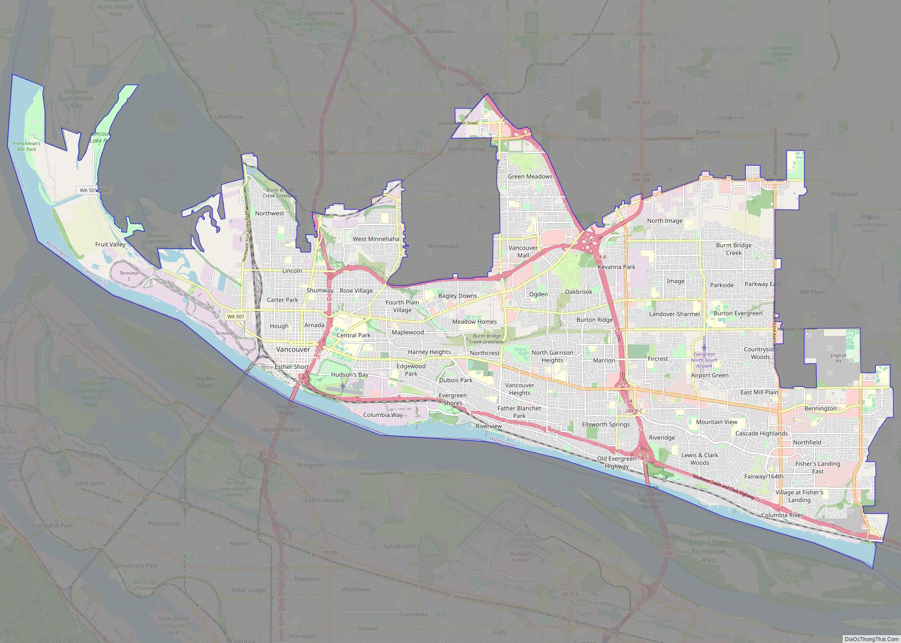
Map of Glendale city, California

Map of Glendale city, California

Glendale is a city in the San Fernando Valley and Verdugo Mountains regions of Los Angeles County, California, United States. At the 2020 U.S. Census the population was 196,543, up from 191,719 at the 2010 census, making it the fourth-largest city in Los Angeles County and the 24th-largest city in California. It is located about … Read more

Map of Knoxville city, Tennessee

Map of Knoxville city, Tennessee

Knoxville is a city in and the county seat of Knox County, Tennessee, United States. As of the 2020 United States census, Knoxville’s population was 190,740, making it the largest city in the East Tennessee Grand Division and the state’s third largest city after Nashville and Memphis. It is the principal city of the Knoxville … Read more

Map of Brownsville city, Texas

Map of Brownsville city, Texas

Brownsville (/ˈbraʊnzˌvɪl/) is a city in and the county seat of Cameron County in the U.S. state of Texas. It is on the western Gulf Coast in South Texas, adjacent to the border with Matamoros, Mexico. The city covers 145.2 sq mi (376.066 km), and had a population of 186,738 at the 2020 census. It is the 139th-largest … Read more

Map of Akron city, Ohio

Map of Akron city, Ohio

Akron (/ˈækrən/) is the fifth-largest city in the U.S. state of Ohio and is the county seat of Summit County. It is located on the western edge of the Glaciated Allegheny Plateau, about 40 miles (64 km) south of downtown Cleveland. At the 2020 census, the city proper had a total population of 190,469, making it … Read more

Map of Shreveport city

Map of Shreveport city

Shreveport (/ˈʃriːvpɔːrt/ SHREEV-port) is a city in the U.S. state of Louisiana. It is the third most populous city in Louisiana after New Orleans and Baton Rouge. The Shreveport–Bossier City metropolitan area, with a population of 393,406 in 2020, is the fourth largest in Louisiana, though 2020 census estimates placed its population at 397,590. The … Read more

Map of Tempe city

Map of Tempe city

Tempe (/tɛmˈpiː/ tem-PEE; Oidbaḍ in O’odham) is a city in Maricopa County, Arizona, United States, with the Census Bureau reporting a 2020 population of 180,587. The city is named after the Vale of Tempe in Greece. Tempe is located in the East Valley section of metropolitan Phoenix; it is bordered by Phoenix and Guadalupe on … Read more

Map of Mobile city

Map of Mobile city

Mobile city overview: Name: Mobile city LSAD Code: 25 LSAD Description: city (suffix) State: Alabama County: Mobile County Founded: 1702 Elevation: 33 ft (10 m) Land Area: 139.48 sq mi (361.26 km²) Water Area: 40.59 sq mi (105.14 km²) Population Density: 1,340.97/sq mi (517.75/km²) Area code: 251 FIPS code: 0150000 GNISfeature ID: 2404278 Website: www.cityofmobile.org Online Interactive Map Mobile online map. Source: Basemap layers … Read more

Map of Fort Lauderdale city

Map of Fort Lauderdale city

Fort Lauderdale (/ˈlɔːdərdeɪl/ LAW-dər-dayl) is a coastal city located in the U.S. state of Florida, 30 miles (48 km) north of Miami along the Atlantic Ocean. It is the county seat of and largest city in Broward County with a population of 182,760 at the 2020 census, making it the tenth largest city in Florida. After … Read more

Map of Chattanooga city, Tennessee

Map of Chattanooga city, Tennessee

Chattanooga (/ˌtʃætəˈnuːɡə/ CHAT-ə-NOO-gə) is a city in and the county seat of Hamilton County, Tennessee, United States. Located along the Tennessee River bordering Georgia, it also extends into Marion County on its western end. With a population of 181,099 in 2020, it is Tennessee’s fourth-largest city and one of the two principal cities of East … Read more

Map of Salem city, Oregon

Map of Salem city, Oregon

Salem (/ˈseɪləm/ SAY-ləm) is the capital of the U.S. state of Oregon, and the county seat of Marion County. It is located in the center of the Willamette Valley alongside the Willamette River, which runs north through the city. The river forms the boundary between Marion and Polk counties, and the city neighborhood of West … Read more