Fort Lauderdale (/ˈlɔːdərdeɪl/ LAW-dər-dayl) is a coastal city located in the U.S. state of Florida, 30 miles (48 km) north of Miami along the Atlantic Ocean. It is the county seat of and largest city in Broward County with a population of 182,760 at the 2020 census, making it the tenth largest city in Florida. After Miami, Fort Lauderdale is the second principal city (as defined by the U.S. Census Bureau) in the Miami metropolitan area, which had a population of 6,166,488 in 2019.
Built in 1838 and first incorporated in 1911, Fort Lauderdale is named after a series of forts built by the United States during the Second Seminole War. The forts took their name from Major William Lauderdale (1782–1838), younger brother of Lieutenant Colonel James Lauderdale. Development of the city did not begin until 50 years after the forts were abandoned at the end of the conflict. Three forts named “Fort Lauderdale” were constructed including the first at the fork of the New River, the second at Tarpon Bend on the New River between the present-day Colee Hammock and Rio Vista neighborhoods, and the third near the site of the Bahia Mar Marina.
Known as the “Venice of America”, Fort Lauderdale has 165 miles of inland waterways across the city.
In addition to tourism, Fort Lauderdale has a diversified economy including marine, manufacturing, finance, insurance, real estate, high technology, avionics/aerospace, film, and television production. The city is a popular tourist destination with an average year-round temperature of 75.5 °F (24.2 °C) and 3,000 hours of sunshine per year. Greater Fort Lauderdale, encompassing all of Broward County, hosted more than 13 million overnight visitors in 2018. Each year nearly 4 million cruise passengers pass through its Port Everglades, making it the third largest cruise port in the world. With over 50,000 registered yachts and 100 marinas, Fort Lauderdale is also known as the yachting capital of the world.”
| Name: | Fort Lauderdale city |
|---|---|
| LSAD Code: | 25 |
| LSAD Description: | city (suffix) |
| State: | Florida |
| County: | Broward County |
| Elevation: | 9 ft (2.75 m) |
| Land Area: | 34.59 sq mi (89.58 km²) |
| Water Area: | 1.71 sq mi (4.44 km²) 4.71% |
| Population Density: | 5,284.07/sq mi (2,040.21/km²) |
| ZIP code: | 33301-33332, 33334-33340, 33345-33346, 33348-33349, 33351, 33355, 33359, 33388, 33394 |
| FIPS code: | 1224000 |
| GNISfeature ID: | 0282693 |
| Website: | www.fortlauderdale.gov |
Discover Fort Lauderdale with our collection of highway/road, reference information, things to do, and an interactive map. Explore the city and take a look at the many places to visit. Whether you’re looking for an adventure or just want to enjoy the scenery, Fort Lauderdale has something for everyone.
Online Interactive Map
Click on ![]() to view map in "full screen" mode.
to view map in "full screen" mode.
Wondering which beaches are near you? Which neighborhoods would suit your tastes? This interactive map lets you find that out and more. This map is designed to give you an overview of the city. It’s very easy to use and it will take you everywhere you need to go in a quick and easy fashion. With the help of this map, you can explore the best the city has to offer in just a few clicks.
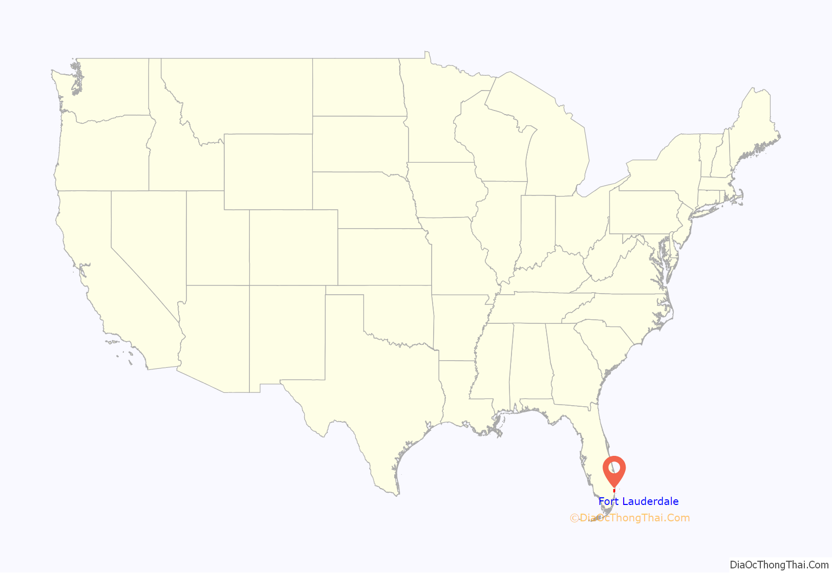
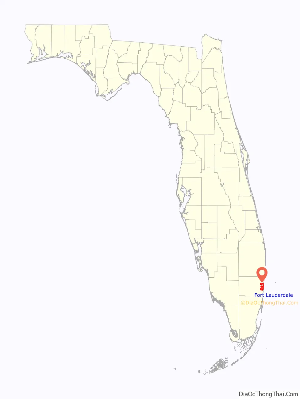
Fort Lauderdale location map. Where is Fort Lauderdale city?
History
The area in which the city of Fort Lauderdale would later be founded was inhabited for more than two thousand years by the Tequesta Indians. Contact with Spanish explorers in the 16th century proved disastrous for the Tequesta, as the Europeans unwittingly brought with them diseases, such as smallpox, to which the native populations possessed no resistance. For the Tequesta, disease, coupled with continuing conflict with their Calusa neighbors, contributed greatly to their decline over the next two centuries. By 1763, there were only a few Tequesta left in Florida, and most of them were evacuated to Cuba when the Spanish ceded Florida to the British in 1763, under the terms of the Treaty of Paris (1763), which ended the Seven Years’ War. Although control of the area changed between Spain, the United Kingdom, the United States, and the Confederate States of America, it remained largely undeveloped until the 20th century.
The Fort Lauderdale area was known as the “New River Settlement” before the 20th century. In the 1830s, there were approximately 70 settlers living along the New River. William Cooley, the local Justice of the Peace, was a farmer and wrecker, who traded with the Seminole Indians. On January 6, 1836, while Cooley was leading an attempt to salvage a wrecked ship, a band of Seminoles attacked his farm, killing his wife and children, and the children’s tutor. The other farms in the settlement were not attacked, but all the white residents in the area abandoned the settlement, fleeing first to the Cape Florida Lighthouse on Key Biscayne, and then to Key West.
The first United States stockade named Fort Lauderdale was built in 1838, and subsequently was a site of fighting during the Second Seminole War. The fort was abandoned in 1842, after the end of the war, and the area remained virtually unpopulated until the 1890s. It was not until Frank Stranahan arrived in the area in 1893 to operate a ferry across the New River, and the Florida East Coast Railroad’s completion of a route through the area in 1896, that any organized development began. The city was incorporated in 1911, and in 1915, was designated the county seat of newly formed Broward County.
Fort Lauderdale’s first major development began in the 1920s, during the Florida land boom. The 1926 Miami Hurricane and the Great Depression of the 1930s caused a great deal of economic dislocation. In July 1935, an African-American man named Rubin Stacy was accused of robbing a white woman at knifepoint. He was arrested and being transported to a Miami jail when police were run off the road by a mob. A group of 100 white men proceeded to hang Stacy from a tree near the scene of his alleged robbery. His body was riddled with some 20 bullets. The murder was subsequently used by the press in Nazi Germany to discredit U.S. critiques of its own persecution of Jews, Communists, and Catholics.
When World War II began, Fort Lauderdale became a major U.S. base, with a Naval Air Station to train pilots, radar operators, and fire control operators. A Coast Guard base at Port Everglades was also established.
Until July 1961, only whites were allowed on Ft. Lauderdale beaches. There were no beaches for African-Americans in Broward County until 1954, when “the Colored Beach,” today Dr. Von D. Mizell-Eula Johnson State Park, was opened in Dania Beach; however, no road was built to it until 1965. On July 4, 1961, African Americans started a series of wade-ins as protests at beaches that were off-limits to them, to protest “the failure of the county to build a road to the Negro beach.” On July 11, 1962, a verdict by Ted Cabot went against the city’s policy of racial segregation of public beaches, and Broward County beaches were desegregated in 1962.
Today, Fort Lauderdale is a major yachting center, one of the nation’s largest tourist destinations, and the center of a metropolitan division with 1.8 million people.
Population size
After the war ended, service members returned to the area, spurring an enormous population explosion that dwarfed the 1920s boom. The 1960 census counted 83,648 people in the city, about 230% of the 1950 figure. A 1967 report estimated that the city was approximately 85% developed, and the 1970 population figure was 139,590.
After 1970, as Fort Lauderdale became essentially built out, growth in the area shifted to suburbs to the west. As cities such as Coral Springs, Miramar, and Pembroke Pines experienced explosive growth, Fort Lauderdale’s population stagnated, and the city actually shrank by almost 4,000 people between 1980, when the city had 153,279 people, and 1990, when the population was 149,377. A slight rebound brought the population back up to 152,397 at the 2000 census. Since 2000, Fort Lauderdale has gained slightly over 18,000 residents through annexation of seven neighborhoods in unincorporated Broward County.
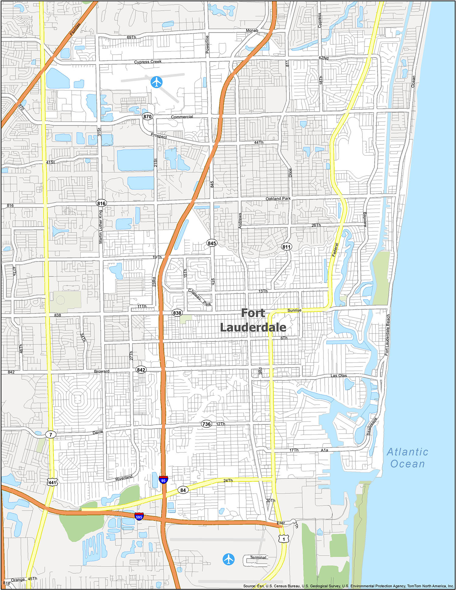
Fort Lauderdale Road Map
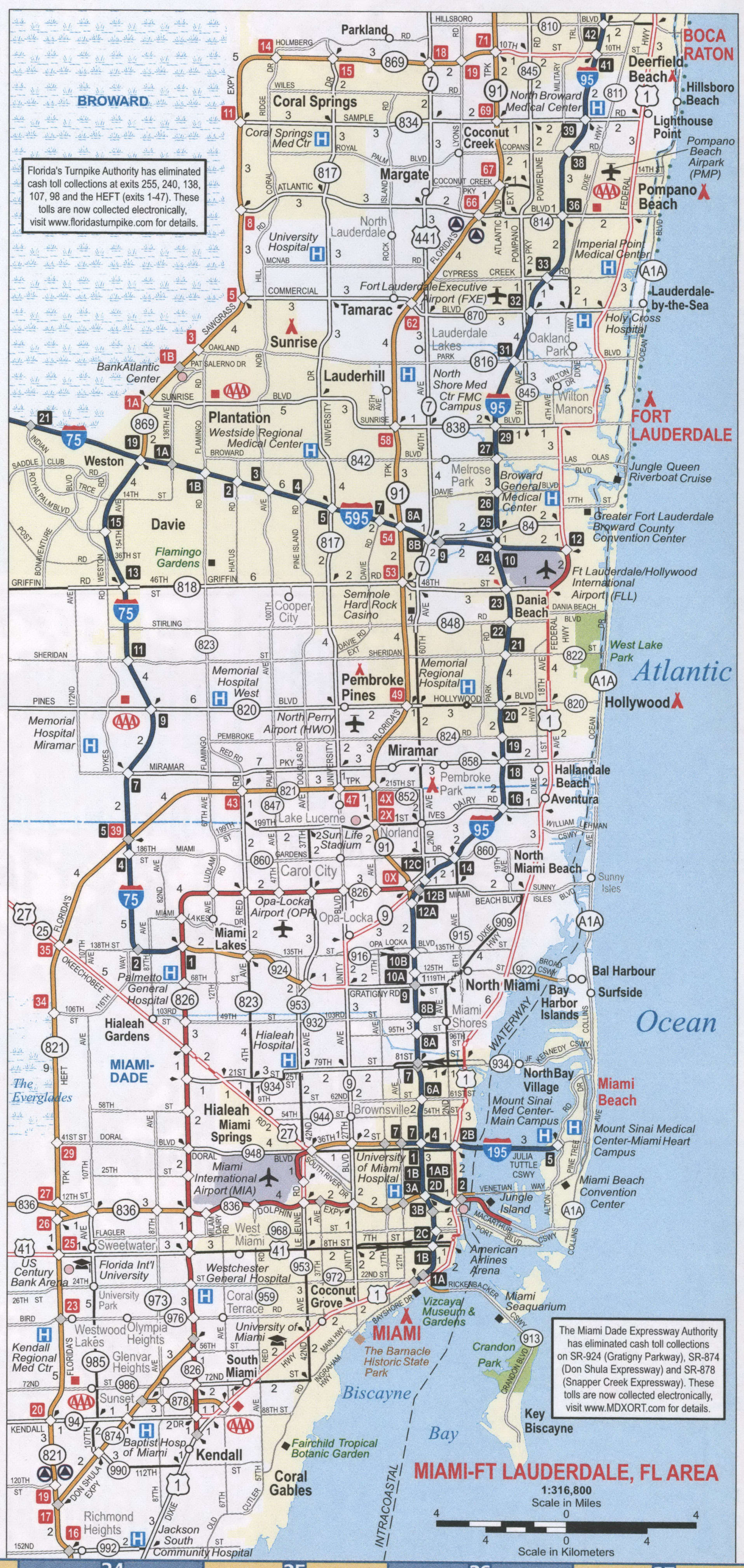
The best way to explore a new city is to explore it with a map. This map gives you all the details you need to know about Fort Lauderdale’s road network in a single printable road map. For example, it shows US Highway 1 and Dixie Hwy (SR-811). Using our free Fort Lauderdale FL map as a guide, you’ll never be lost again. But for travel outside the city, take a look at our Florida road map that you can download for free.
US Highways: 1, 441, Dixie Hwy (SR-811), Federal HwyMajor Roads: 3rd Ave, 6th St, 9th Ave, 11th St, 12th St, 13th St, 15th Ave, 17th St, 18th Ave, 19th St, 21st Ave, 23rd Ave, 24th St, 26th St, 27th Ave, 30th St, 31st Ave, 34th Ave, 62nd St, 69th St, Andrews Ave, Bayview Dr, Broward Blvd (FL-842), Chateau Park Dr, Commercial Blvd (FL-870), Cypress Creek Rd, Davie Blvd (FL-736), Eller Dr, Fairmont Ave, Fort Lauderdale Beach Blvd, J W Mclaughlin Ave, Las Olas Blvd, Lauderdale Manor Dr, Martin Luther King Ave, Mcnab Rd, Oakland Park Blvd (FL-816), Ocean Blvd, Powerline Rd (FL-845), Prospect Rd, Riverland Rd, Seabreeze Blvd, Sistrunk Blvd, State Road 84, Sunrise Blvd (FL-838), Terminal Dr
Exploring a new city can be a daunting task. However, with the help of our free Fort Lauderdale FL map, you will be able to navigate the city with ease. This printable road map shows all the major highways and roads in the city, including US Highway 1 and Dixie Hwy (SR-811). To plan a trip outside of the city, you can also use our Florida road map, which is available for download. With these helpful maps, you’ll never be lost again!
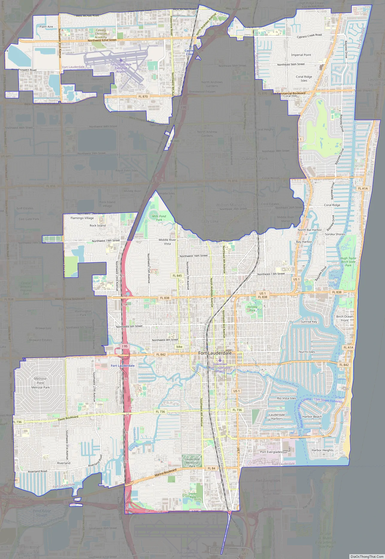
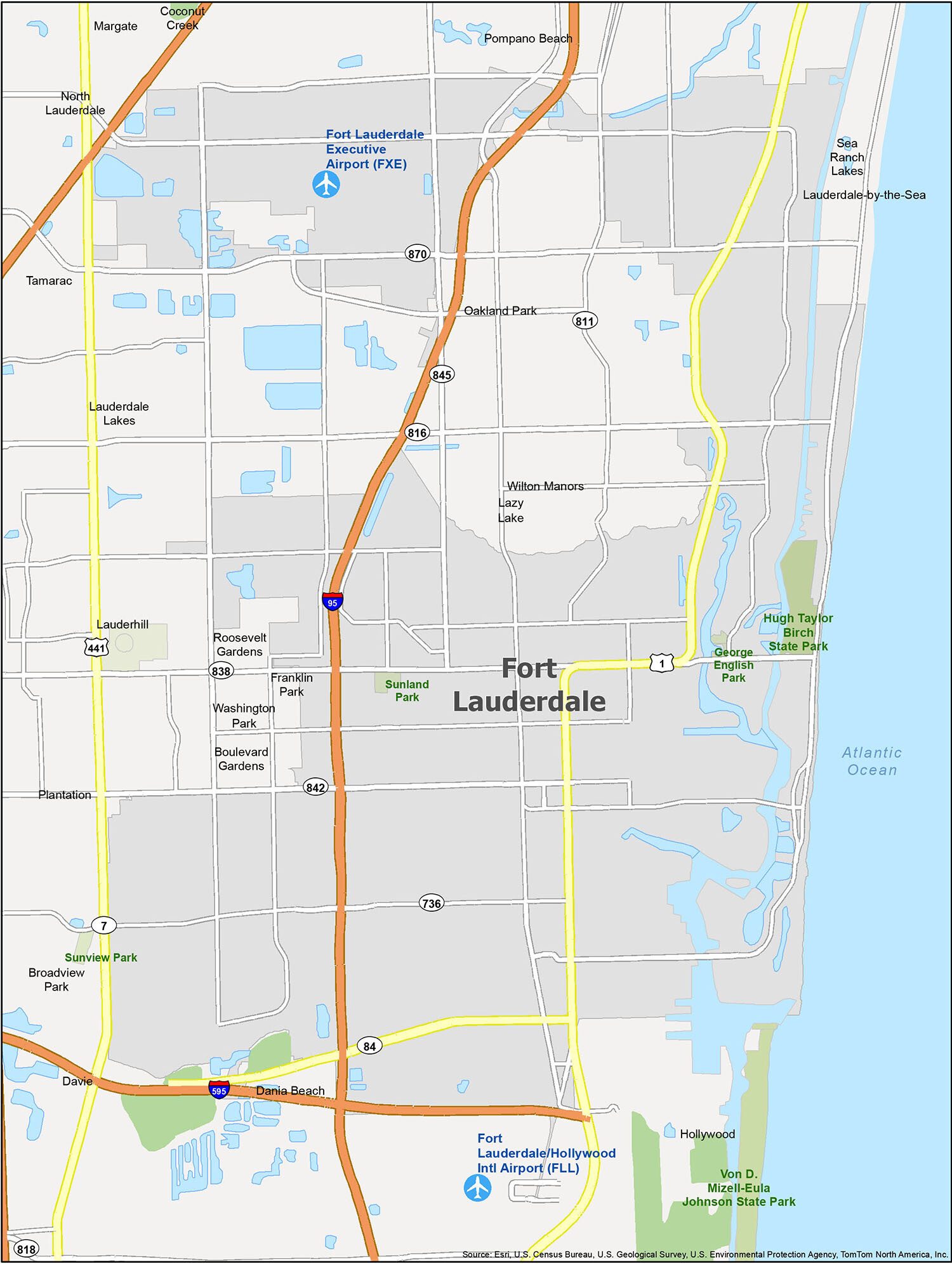
Discover the beauty of Fort Lauderdale with our new reference map. This map includes all the parks, neighborhoods, and populated areas that are essential to knowing the city. With this map, you can explore the city with ease and find the perfect place to go. Airports, cities, towns, villages, and census-designated places are all included, so you can be sure you’re going the right way.
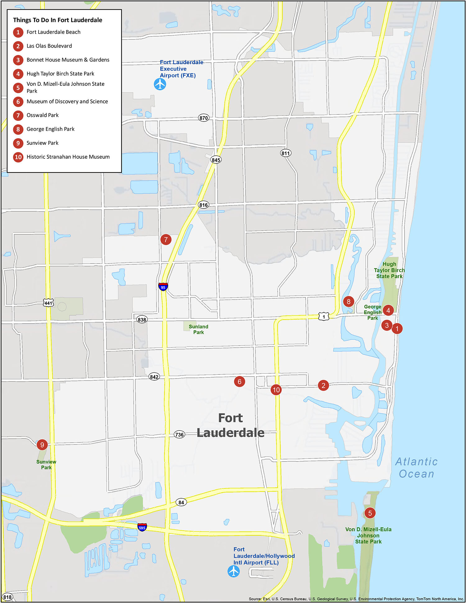
10 things to do in Fort Lauderdale city
Ft. Lauderdale is home to a variety of major attractions and points of interest, making it a great destination for anyone looking to explore. From its beautiful beaches and parks to its many museums and galleries, there is something for everyone. Whether you’re looking for a relaxing getaway or an exciting adventure, our map of Fort Lauderdale will help you find the perfect destination.
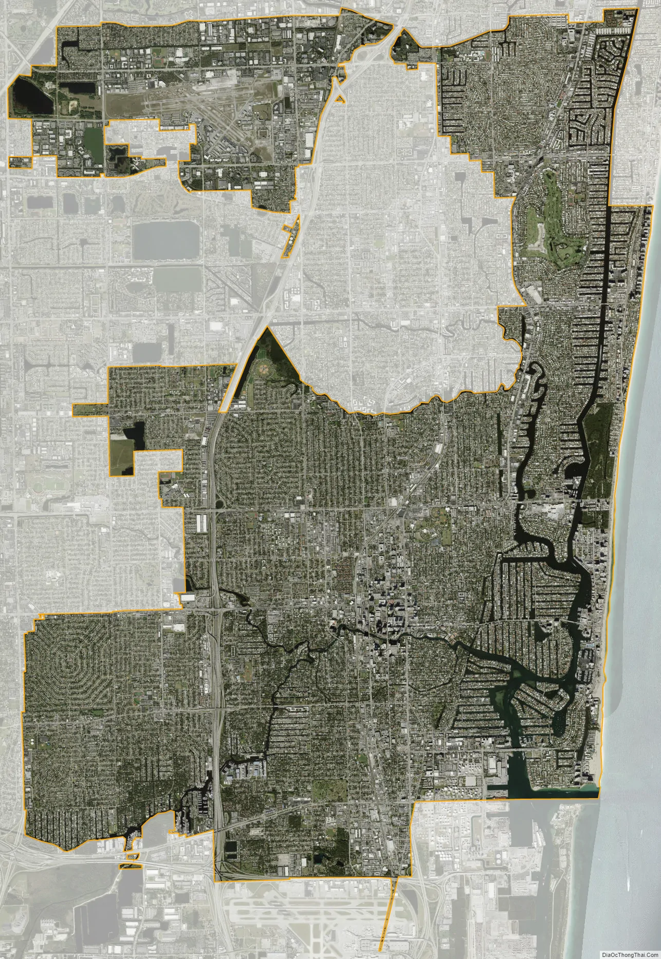
Fort Lauderdale city Satellite Map
Geography
Location
According to the United States Census Bureau, the city has a total area of 38.6 square miles (99.9 km), 34.7 square miles (90.0 km) of which is land and 3.8 square miles (9.9 km) of which is water (9.87%). Fort Lauderdale is known for its extensive network of canals; there are 165 miles (266 km) of waterways within the city limits.
The city of Fort Lauderdale is adjacent to the Atlantic Ocean, includes 7 miles (11 km) of beaches, and borders the following municipalities:
On its east:
- Lauderdale-by-the-Sea
- Sea Ranch Lakes
- Victoria Park
On its south:
On its southwest:
On its west:
- Plantation
- Lauderhill
- Lauderdale Lakes
On its northwest:
On its north:
The northwestern section of Fort Lauderdale is separate from the remainder of the city, connected only by the Cypress Creek Canal as it flows under I-95. This section of Fort Lauderdale borders the cities of Tamarac and Oakland Park on its south side. Oakland Park also borders Fort Lauderdale on the west side of its northeastern portion. The greater portion of Fort Lauderdale in the south is bordered, along its north side by Wilton Manors.
Off the coast of Fort Lauderdale is the Osborne Reef, an artificial reef made of discarded tires that has proven to be an ecological disaster. The dumping began in the 1960s, with the intent of providing habitat for fish, while disposing of trash from the land. However, in the rugged and corrosive environment of the ocean, nylon straps used to secure the tires wore out, cables rusted, and tires broke free. The tires posed a particular threat after breaking free from their restraints. The tires then migrated shoreward, and ran into a living reef tract, washed up on its slope, and killed many things in their path. In recent years, thousands of tires have also washed up on nearby beaches, especially during hurricanes. Local authorities are now working to remove the 700,000 tires, in cooperation with the U.S. Army, Navy, and Coast Guard.
Neighborhoods
Fort Lauderdale has a program for designating and recognizing neighborhoods. Under the Neighborhood Organization Recognition Program, more than 60 distinct neighborhoods have received official recognition from the city. An additional 25–30 neighborhoods exist without official recognition, although the city’s neighborhood map displays them as well.
Climate
According to the Köppen climate classification, Fort Lauderdale has a tropical rainforest climate (Köppen Af), landing just above a tropical monsoon climate (Köppen Am) in terms of precipitation. While the city does not have a true dry season, much of the seasonal rainfall comes between May and October. Winters are frequently dry and sunny, and drought can be a concern in some years.
Fort Lauderdale is situated in USDA hardiness zone 10b.
The wet season runs from May through October, and weather is typically hot, humid, and wet with average high temperatures of 86–90 °F (30–32 °C) and lows of 73–78 °F (23–26 °C). During this period, more than half of summer days may bring brief afternoon or evening thunderstorms with lightning and bursts of intense rainfall. The record high temperature of 100 °F (38 °C) was recorded on June 22, 2009, and August 4, 1944.
The dry season often arrives some time in November, and lasts through early to mid April. Seasonable weather is often warm, dry, and sunny. Average high temperatures of 75–83 °F (24–28 °C) and lows of 60–70 °F (16–21 °C) are typical in the dry season. On rare occasions, cool fronts may make it all the way south to Fort Lauderdale, and the city will see a day or two of highs in the 60s °F (16–21 °C) and lows in the 40s °F (4–10 °C). Rare frosts occur every few decades, and only once in recorded history have snow flurries been reported in the air, which occurred on January 19, 1977. During the dry season (winter), brush fires can be a concern in many years.
Annual average precipitation is 60.95 inches (1,550 mm), with most of it occurring during the wet season from May through October. However, rainfall occurs in all months, even during the drier months from November through April, such as during the April 2023 flash flood where about two feet of rain fell in half a day. Fort Lauderdale has an average of 131 precipitation days annually. The hurricane season is between June 1 and November 30, with major hurricanes most likely to affect the city or state in September and October. The most recent storms to directly affect the city were Hurricane Irma in 2017, in addition to Hurricane Katrina and Hurricane Wilma, both of which struck the city in 2005. Other direct hits were Hurricane Cleo in 1964, Hurricane King in 1950, and the 1947 Fort Lauderdale Hurricane. On April 12, 2023, Fort Lauderdale received 25.91 inches (658 mm) of rainfall, causing historic flooding and the temporary closure of the Fort Lauderdale–Hollywood International Airport.
See also
Map of Florida State and its subdivision:- Alachua
- Baker
- Bay
- Bradford
- Brevard
- Broward
- Calhoun
- Charlotte
- Citrus
- Clay
- Collier
- Columbia
- Desoto
- Dixie
- Duval
- Escambia
- Flagler
- Franklin
- Gadsden
- Gilchrist
- Glades
- Gulf
- Hamilton
- Hardee
- Hendry
- Hernando
- Highlands
- Hillsborough
- Holmes
- Indian River
- Jackson
- Jefferson
- Lafayette
- Lake
- Lee
- Leon
- Levy
- Liberty
- Madison
- Manatee
- Marion
- Martin
- Miami-Dade
- Monroe
- Nassau
- Okaloosa
- Okeechobee
- Orange
- Osceola
- Palm Beach
- Pasco
- Pinellas
- Polk
- Putnam
- Saint Johns
- Saint Lucie
- Santa Rosa
- Sarasota
- Seminole
- Sumter
- Suwannee
- Taylor
- Union
- Volusia
- Wakulla
- Walton
- Washington
- Alabama
- Alaska
- Arizona
- Arkansas
- California
- Colorado
- Connecticut
- Delaware
- District of Columbia
- Florida
- Georgia
- Hawaii
- Idaho
- Illinois
- Indiana
- Iowa
- Kansas
- Kentucky
- Louisiana
- Maine
- Maryland
- Massachusetts
- Michigan
- Minnesota
- Mississippi
- Missouri
- Montana
- Nebraska
- Nevada
- New Hampshire
- New Jersey
- New Mexico
- New York
- North Carolina
- North Dakota
- Ohio
- Oklahoma
- Oregon
- Pennsylvania
- Rhode Island
- South Carolina
- South Dakota
- Tennessee
- Texas
- Utah
- Vermont
- Virginia
- Washington
- West Virginia
- Wisconsin
- Wyoming


