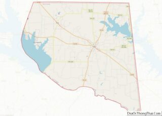
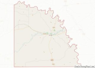
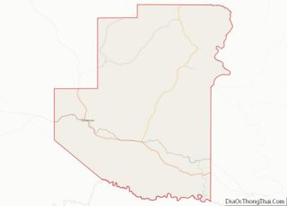
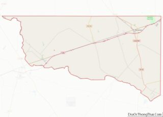
Map of Morgan County

Map of Morgan County, Alabama

Morgan County is a county in the north central part of the U.S. state of Alabama. As of the 2020 census, its population was 123,421. The county seat is Decatur. The county was created by the Alabama Territorial legislature on February 6, 1818, from land acquired from the Cherokee people in the Treaty of Turkeytown, … Read more

Map of Aleutians East Borough

Map of Aleutians East Borough, Alaska

Aleutians East Borough (/əˈljuːʃənz/) is a 2nd class borough in the U.S. state of Alaska. As of the 2020 census the borough’s population was 3,420. The borough seat is Sand Point. Aleutians East Borough overview: Name: Aleutians East Borough FIPS code: 02-013 State: Alaska Named for: Aleutian Islands Seat: Sand Point Largest city: Akutan Total … Read more

Map of North Slope Borough

Map of North Slope Borough, Alaska

North Slope Borough overview: Name: North Slope Borough FIPS code: 02-185 State: Alaska Named for: Alaska North Slope Seat: Utqiaġvik Largest city: Utqiaġvik Total Area: 94,796 sq mi (245,520 km²) Land Area: 88,695 sq mi (229,720 km²) Total Population: 11,031 Population Density: 0.12/sq mi (0.045/km²) North Slope Borough location map. Where is North Slope Borough? History The borough was established in 1972 … Read more

Map of La Paz County

Map of La Paz County, Arizona

La Paz County overview: Name: La Paz County FIPS code: 04-012 State: Arizona Founded: January 1, 1983 Named for: La Paz, Arizona Seat: Parker Largest town: Parker Total Area: 4,514 sq mi (11,690 km²) Land Area: 4,500 sq mi (12,000 km²) Total Population: 16,557 Population Density: 3.7/sq mi (1.4/km²) Time zone: UTC−7 (Mountain) Website: www.co.la-paz.az.us La Paz County location map. Where is … Read more

Map of Carroll County

Map of Carroll County, Arkansas

Carroll County overview: Name: Carroll County FIPS code: 05-015 State: Arkansas Founded: November 1, 1833 Named for: Charles Carroll Seat: Berryville and Eureka Springs Largest city: Berryville Total Area: 639 sq mi (1,660 km²) Land Area: 630 sq mi (1,600 km²) Total Population: 28,260 Population Density: 44/sq mi (17/km²) Time zone: UTC−6 (Central) Summer Time Zone (DST): UTC−5 (CDT) Website: carrollcounty.us Carroll … Read more

Map of Franklin County

Map of Franklin County, Arkansas

Franklin County is a county in Arkansas. As of the 2020 census, the population was 17,097. The county has two county seats, Charleston and Ozark. The county was formed on December 19, 1837, and named for Benjamin Franklin, American statesman. To the north of the Arkansas River, which bisects Franklin County, the county is wet … Read more

Map of Lincoln County

Map of Lincoln County, Arkansas

Lincoln County is located between the Arkansas Timberlands and Arkansas Delta in the U.S. state of Arkansas. It is also within the Pine Bluff metro area, and on the outer edge of the Central Arkansas region. The county is named for President Abraham Lincoln. Created as Arkansas’s 65th county on March 28, 1871, Lincoln County … Read more

Map of Poinsett County

Map of Poinsett County, Arkansas

Poinsett County is a county located in the U.S. state of Arkansas. As of the 2020 census, the population was 22,965. The county seat is Harrisburg. Poinsett County is included in the Jonesboro–Paragould Combined Statistical Area. Poinsett County overview: Name: Poinsett County FIPS code: 05-111 State: Arkansas Founded: February 28, 1838 Named for: Joel Roberts … Read more

Map of Washington County

Map of Washington County, Arkansas

Washington County is a regional economic, educational, and cultural hub in the Northwest Arkansas region. Created as Arkansas’s 17th county on November 30, 1848, Washington County has 13 incorporated municipalities, including Fayetteville, the county seat, and Springdale. The county is also the site of small towns, bedroom communities, and unincorporated places. The county is named … Read more

Map of Imperial County

Map of Imperial County, California

Imperial County (Spanish: Condado de Imperial) is a county located on the southeast border of the U.S. state of California. As of the 2020 census, the population was 179,702, making it the least populous county in Southern California. The county seat is El Centro. Imperial is the most recent California county to be established, as … Read more

Map of Nevada County

Map of Nevada County, California

Nevada County (/nɪˈvædə/ (listen)) is a county located in the U.S. state of California, in the Sierra Nevada. As of the 2020 census, its population was 102,241. The county seat is Nevada City. Nevada County comprises the Truckee–Grass Valley micropolitan statistical area, which is also included in the Sacramento–Roseville combined statistical area, part of the … Read more

Map of Shasta County

Map of Shasta County, California

Shasta County (/ˈʃæstə/ (listen)), officially the County of Shasta, is a county in the northern portion of the U.S. state of California. Its population is 182,155 as of the 2020 census, up from 177,223 from the 2010 census. The county seat is Redding. Shasta County comprises the Redding, California metropolitan statistical area. The county occupies … Read more