Portsmouth is an independent city in southeast Virginia, United States. It lies across the Elizabeth River from Norfolk. As of the 2020 census, the population was 97,915. It’s the 9th most populous city in Virginia and is part of the Hampton Roads metropolitan area.
The Norfolk Naval Shipyard is a historic and active U.S. Navy facility located in Portsmouth.
| Name: | Portsmouth City |
|---|---|
| FIPS code: | 51-740 |
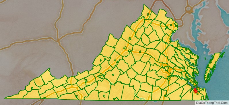
| State: | Virginia |
| Founded: | 1752 |
| Named for: | Portsmouth, England |
| Total Area: | 46.68 sq mi (120.91 km²) |
| Land Area: | 33.30 sq mi (86.25 km²) |
| Total Population: | 97,840 |
| Population Density: | 2,940.39/sq mi (1,135.29/km²) |
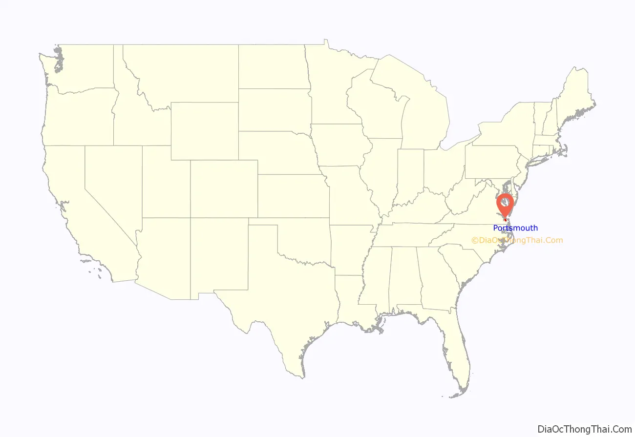
Portsmouth City location map. Where is Portsmouth City?
History
In 1620, the future site of Portsmouth was recognized as a suitable shipbuilding location by John Wood, a shipbuilder, who petitioned King James I of England for a land grant. The surrounding area was soon settled as a plantation community.
Portsmouth was founded by Colonel William Crawford, a member of the Virginia House of Burgesses. It was established as a town in 1752 by an act of the Virginia General Assembly and was named for Portsmouth, England.
In 1767, Andrew Sprowle, a shipbuilder, founded the Gosport Shipyard adjacent to Portsmouth. The Gosport Shipyard at Portsmouth was owned by the Commonwealth of Virginia after the American Revolutionary War and was sold to the new United States federal government.
In 1855, the Portsmouth and Norfolk area suffered an epidemic of yellow fever which killed 1 of every three citizens. It became an independent city from Norfolk County in 1858.
During the American Civil War, in 1861, Virginia joined the Confederate States of America. Fearing that the Confederacy would take control of the shipyard at Portsmouth, the shipyard commander ordered the burning of the shipyard. The Confederate forces did in fact take over the shipyard, and did so without armed conflict through an elaborate ruse orchestrated by civilian railroad builder William Mahone (soon to become a famous Confederate officer). The Union forces withdrew to Fort Monroe across Hampton Roads, which was the only land in the area which remained under Union control.
In early 1862, the Confederate ironclad warship CSS Virginia was rebuilt using the burned-out hulk of USS Merrimack. Virginia engaged the Union ironclad USS Monitor in the famous Battle of Hampton Roads during the Union blockade of Hampton Roads. The Confederates burned the shipyard again when they left in May 1862.
Following the recapture of Norfolk and Portsmouth by the Union forces, the name of the shipyard was changed to Norfolk Naval Shipyard. The name of the shipyard was derived from its location in Norfolk County. The Norfolk Naval Shipyard today is located entirely within the city limits of Portsmouth, Virginia. The Norfolk Naval Shipyard name has been retained to minimize any confusion with the Portsmouth Naval Shipyard, which itself is actually located in Kittery, Maine, across the Piscataqua River from Portsmouth, New Hampshire.
During and after World War II, the shipyard flourished and suburban development surrounded both Norfolk and Portsmouth. Portsmouth continued as the county seat of Norfolk County until 1963 when the new city of Chesapeake was formed in a political consolidation with the city of South Norfolk. Portsmouth’s other county neighbor, the former Nansemond County, also consolidated with a smaller city, forming the new city of Suffolk in 1974. One of the older cities of Hampton Roads, in the early 21st century, Portsmouth was undergoing moderate urban renewal in the downtown.
The APM “MAERSK” marine terminal for container ships opened in 2007 in the West Norfolk section.
Timeline
- 1752 – Portsmouth founded by politician William Crawford; named after Portsmouth, England.
- 1779 – Portsmouth sacked by British forces during the American Revolutionary War.
- 1812 – Dismal Swamp Canal opens.
- 1821 – Fire.
- 1822 – Norfolk-Portsmouth steam ferry begins operating.
- 1824 – October 25: Lafayette visits Portsmouth.
- 1836 – Town of Portsmouth incorporated.
- 1837 – Portsmouth & Roanoke Railroad begins operating.
- 1840 – Population: 6,477.
- 1846 – Norfolk County Courthouse built.
- 1850 – Population: 8,626.
- 1855 – Yellow fever outbreak.
- 1858 – City of Portsmouth incorporated as an independent city (separated from Norfolk County).
- 1865 – Zion Baptist Church founded.
- 1867 – Virginia Baptist State Convention organized during a meeting in Portsmouth.
- 1870 – Population: 10,590.
- 1890 – Became a stop on the Atlantic and Danville Railway.
- 1894 – Annexation of portions of Norfolk County North of the city
- 1900 – Lyceum Theatre in business.
- 1910 – Population: 33,190.
- 1909 – Annexation of portions of Norfolk County West of the city.
- 1914 – Portsmouth Public Library opens.
- 1919 – Expansion via the annexation of parts of Norfolk County that included the port zone (Pinner’s Point) along the Elizbeth River to the north and residential areas to the West.
- 1922 – Chevra Thilim Synagogue built.
- 1939 – Lyric Theatre in business.
- 1948 – The fourth annexation since becoming an independent city, pushing the city boundary westward to Western Branch.
- 1949 – Portsmouth Naval Shipyard Museum established.
- 1950 – Population: 80,039.
- 1952 – Downtown Tunnel opens.
- 1955 – Portsmouth Historical Association founded.
- 1957 – WAVY-TV begins broadcasting.
- 1960 – Population: 114,773. Portsmouth annexes additional portions of Norfolk County, including ten square miles and 36,000 residents.
- 1963 – Public Library’s “Local History Room” established.
- 1966 – Virginia Sports Hall of Fame and Museum established.
- 1968 – Further annexation of Norfolk County including ten square miles of land, 14 square miles of water area, and 11,000 residents, all within the norther one-third of Western Branch Borough.
- 1974 – Richard Joseph Davis becomes mayor.
- 1981 – Portsmouth Times newspaper begins publication.
- 1984 – James W. Holley III becomes mayor.
- 1993 – Bobby Scott becomes U.S. representative for Virginia’s 3rd congressional district.
- 1998 – Museum of Military History established.
- 2001 – Randy Forbes becomes U.S. representative for Virginia’s 4th congressional district.
- 2010 – Population: 95,535.
- 2017 – John L. Rowe, Jr. becomes mayor.
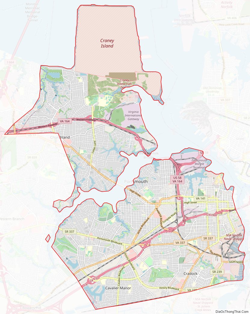
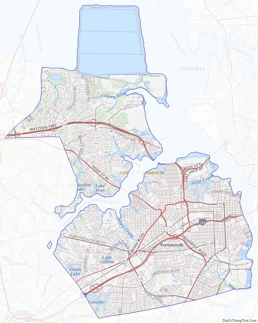
Portsmouth City Road Map
Geography
According to the U.S. Census Bureau, Portsmouth has a total area of 47 square miles (120 km), of which 34 square miles (88 km) is land and 13 square miles (34 km) (28.0%) is water. The city is also bisected by the West Branch of the Elizabeth River which flows from neighboring Suffolk.
Climate
Portsmouth’s mild humid subtropical climate means outdoor activities can be enjoyed year round. The weather in Portsmouth is temperate and seasonal. Summers are hot and humid with warm evenings. The mean annual temperature is 65 °F (18 °C), with an average annual snowfall of 3 inches and an average annual rainfall of 47 inches. No measurable snow fell in 1999. The wettest seasons are the spring and summer, although rainfall is fairly constant all year round. The highest recorded temperature was 105.0 °F in 1980. The lowest recorded temperature was -3.0 °F on January 21, 1985.
Additionally, the geographic location of the city, with respect to the principal storm tracks, is especially favorable, as it is south of the average path of storms originating in the higher latitudes, and north of the usual tracks of hurricanes and other major tropical storms. Snow falls rarely, averaging 3 inches (76 mm) per season.
Portsmouth City Topographic Map
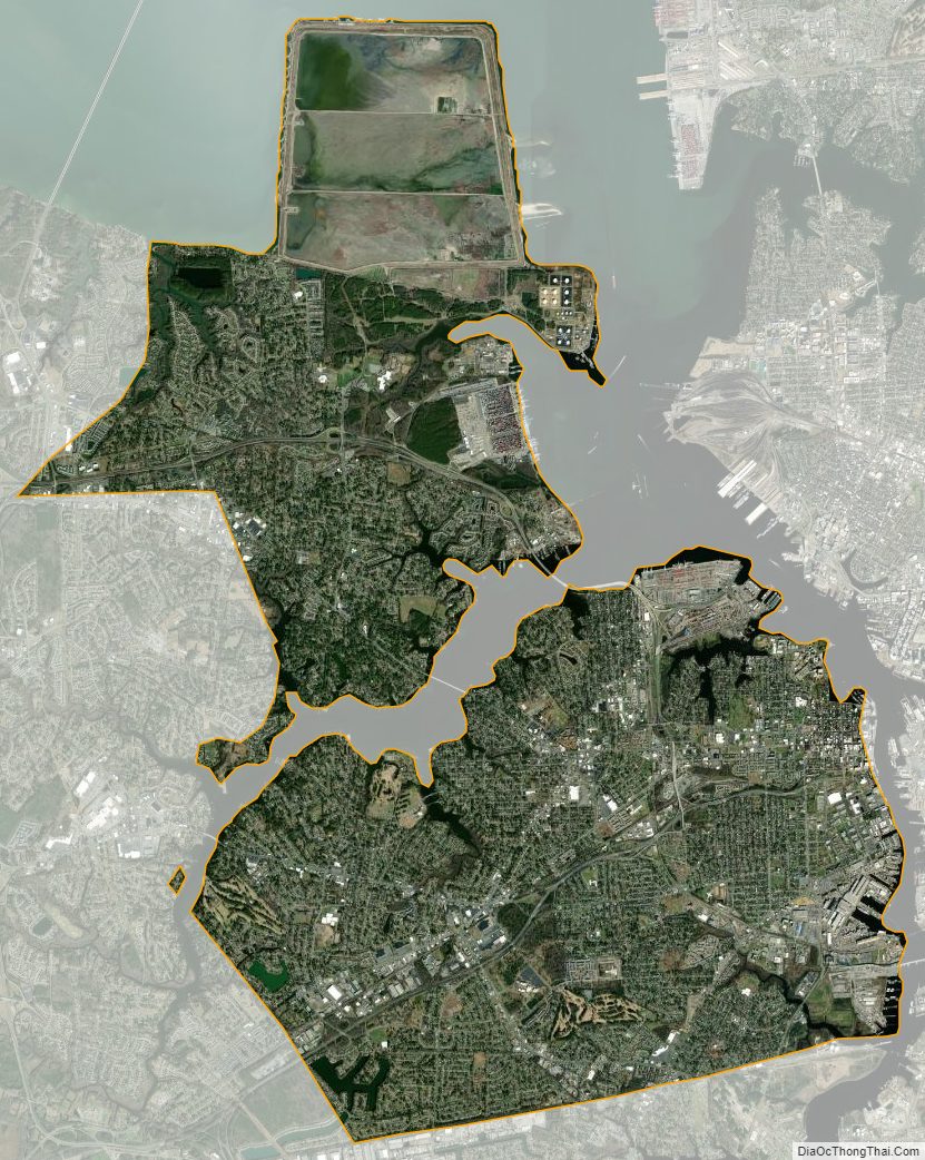
Portsmouth City Satellite Map
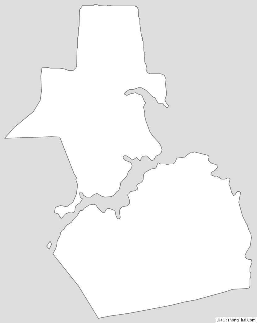
Portsmouth City Outline Map