San Francisco (/ˌsæn frənˈsɪskoʊ/; Spanish for “Saint Francis”), officially the City and County of San Francisco, is a commercial, financial, and cultural center of Northern California. The city proper is the fourth most populous in California, with 815,201 residents as of 2021, and covers a land area of 46.9 square miles (121 square kilometers), at the end of the San Francisco Peninsula, making it the second most densely populated large U.S. city after New York City and the fifth most densely populated U.S. county, behind only four of the five New York City boroughs. Among the 91 U.S. cities proper with over 250,000 residents, San Francisco was ranked first by per capita income and sixth by aggregate income as of 2021. Colloquial nicknames for San Francisco include SF, San Fran, The City, Frisco, and Baghdad by the Bay.
San Francisco was founded on June 29, 1776, when Settlers from New Spain established the Presidio of San Francisco at the Golden Gate and Mission San Francisco de Asís a few miles away, both named for Francis of Assisi. The California Gold Rush of 1849 brought rapid growth, transforming an unimportant hamlet into a busy port, making it the largest city on the West Coast at the time; between 1870 and 1900, approximately one quarter of California’s population resided in the city proper. In 1856, San Francisco became a consolidated city-county. After three-quarters of the city was destroyed by the 1906 earthquake and fire, it was quickly rebuilt, hosting the Panama-Pacific International Exposition nine years later. In World War II, it was a major port of embarkation for naval service members shipping out to the Pacific Theater. It then became the birthplace of the United Nations in 1945. After the war, the confluence of returning servicemen, significant immigration, liberalizing attitudes, the rise of the beatnik and hippie countercultures, the sexual revolution, the peace movement growing from opposition to United States involvement in the Vietnam War, and other factors led to the Summer of Love and the gay rights movement, cementing San Francisco as a center of liberal activism in the United States.
San Francisco and the surrounding San Francisco Bay Area are a global center of economic activity and the arts and sciences, spurred by leading universities, high-tech, healthcare, finance, insurance, real estate, and professional services sectors. As of 2020, the metropolitan area, with 6.7 million residents, ranked 5th by GDP ($874 billion) and 2nd by GDP per capita ($131,082) across the OECD countries, ahead of global cities like Paris, London, and Singapore. San Francisco anchors the 13th most populous metropolitan statistical area in the United States with 4.6 million residents, and the fourth-largest by aggregate income and economic output, with a GDP of $669 billion in 2021. The wider San Jose–San Francisco–Oakland Combined Statistical Area is the fifth most populous, with 9.5 million residents, and the third-largest by economic output, with a GDP of $1.25 trillion in 2021. In the same year, San Francisco proper had a GDP of $236.4 billion, and a GDP per capita of $289,990. San Francisco was ranked seventh in the world and third in the United States on the Global Financial Centres Index as of March 2022. Despite an exodus of business from the city center accelerated by the COVID-19 pandemic, the Bay Area is still the home to four of the world’s ten largest companies by market capitalization, and the city proper houses the headquarters of numerous companies inside and outside of technology, including Wells Fargo, Salesforce, Uber, Airbnb, Twitter, Levi’s, Gap, Dropbox, and Lyft.
One of the top tourist destinations in the United States, San Francisco is known for its steep rolling hills and eclectic mix of architecture across varied neighborhoods, as well as its cool summers, fog, and landmarks, including the Golden Gate Bridge, cable cars, Alcatraz, and Chinatown and Mission districts. The city is home to a number of educational and cultural institutions, such as the University of California, San Francisco, the University of San Francisco, San Francisco State University, the San Francisco Conservatory of Music, the de Young Museum, the San Francisco Museum of Modern Art, the San Francisco Symphony, the San Francisco Ballet, the San Francisco Opera, the SFJAZZ Center, and the California Academy of Sciences. Two professional sports teams, MLB’s San Francisco Giants, and the NBA’s Golden State Warriors, all play their home games within San Francisco proper. Transport to, from, and within San Francisco is also among the most robust in the nation, with a main international airport flying to over 125 destinations and a light rail and bus network in tandem with the BART and Caltrain systems connecting nearly every part of San Francisco with the wider region.
| Name: | San Francisco County |
|---|---|
| FIPS code: | 06-075 |
| State: | California |
| Named for: | St. Francis of Assisi |
| Land Area: | 46.9 sq mi (121.48 km²) |
| Population Density: | 18,634.65/sq mi (7,194.31/km²) |
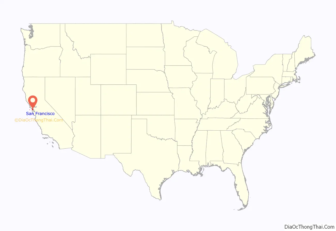
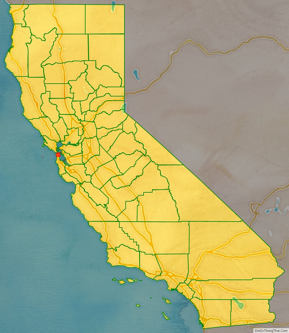
San Francisco County location map. Where is San Francisco County?
History
3000 BC–1845 AD: Early history and rule by Spain and Mexico
The earliest archaeological evidence of human habitation of the territory of the city of San Francisco dates to 3000 BC. The Yelamu group of the Ohlone people resided in a few small villages when an overland Spanish exploration party (led by Don Gaspar de Portolá) arrived on November 2, 1769, the first documented European visit to San Francisco Bay.
The first European maritime presence occurred on August 5, 1775, when the Spanish San Carlos commanded by Juan Manuel de Ayala became the first ship to anchor in the bay. Soon after, on March 28, 1776, the Spanish explorer Juan Bautista de Anza established the Presidio of San Francisco. On October 9, Mission San Francisco de Asís (Mission Dolores) was founded by Padre Francisco Palóu. In 1804, the province of Alta California was created, which included San Francisco.
In 1821, the Presidio and the Mission were ceded to Mexico by Spain. The extensive California mission system gradually lost its influence during the period of Mexican rule. Agricultural land became largely privatized as ranchos, as was occurring in other parts of California. Coastal trade increased, including a half-dozen barques from various Atlantic ports which regularly sailed in California waters.
Yerba Buena (after a native herb), a trading post with settlements between the Presidio and Mission grew up around the Plaza de Yerba Buena. The plaza was later renamed Portsmouth Square (now located in the city’s Chinatown and Financial District). The Presidio was commanded in 1833 by Captain Mariano G. Vallejo.
In 1834, Francisco de Haro became the first Alcalde of Yerba Buena. De Haro was a native of Mexico, from the west coast city of Compostela, Nayarit. A land survey of Yerba Buena was made by the Swiss immigrant Jean Jacques Vioget as prelude to the city plan. The second Alcalde José Joaquín Estudillo was a Californio from a prominent Monterey family. In 1835, while in office, he approved the first land grant in Yerba Buena: to William Richardson, a naturalized Mexican citizen of English birth. Richardson had arrived in San Francisco aboard a whaling ship in 1822. In 1825, he married Maria Antonia Martinez, eldest daughter of the Californio Ygnacio Martínez.
1846–1905: Population growth and American acquisition
Yerba Buena began to attract American and European settlers; an 1842 census listed 21 residents (11%) born in the United States or Europe, as well as one Filipino merchant. Commodore John D. Sloat claimed California for the United States on July 7, 1846, during the Mexican–American War, and Captain John B. Montgomery arrived to claim Yerba Buena two days later. Yerba Buena was renamed San Francisco on January 30 of the next year, and Mexico officially ceded the territory to the United States at the end of the war in 1848. Despite its attractive location as a port and naval base, San Francisco was still a small settlement with inhospitable geography. Its 1847 population was said to be 459.
The California Gold Rush brought a flood of treasure seekers (known as “forty-niners”, as in “1849”). With their sourdough bread in tow, prospectors accumulated in San Francisco over rival Benicia, raising the population from 1,000 in 1848 to 25,000 by December 1849. The promise of wealth was so strong that crews on arriving vessels deserted and rushed off to the gold fields, leaving behind a forest of masts in San Francisco harbor. Some of these approximately 500 abandoned ships were used at times as storeships, saloons, and hotels; many were left to rot, and some were sunk to establish title to the underwater lot. By 1851, the harbor was extended out into the bay by wharves while buildings were erected on piles among the ships. By 1870, Yerba Buena Cove had been filled to create new land. Buried ships are occasionally exposed when foundations are dug for new buildings.
California was quickly granted statehood in 1850, and the U.S. military built Fort Point at the Golden Gate and a fort on Alcatraz Island to secure the San Francisco Bay. San Francisco County was one of the state’s 18 original counties established at California statehood in 1850. Until 1856, San Francisco’s city limits extended west to Divisadero Street and Castro Street, and south to 20th Street. In 1856, the California state government divided the county. A straight line was then drawn across the tip of the San Francisco Peninsula just north of San Bruno Mountain. Everything south of the line became the new San Mateo County while everything north of the line became the new consolidated City and County of San Francisco.
Entrepreneurs sought to capitalize on the wealth generated by the Gold Rush. Silver discoveries, including the Comstock Lode in Nevada in 1859, further drove rapid population growth. With hordes of fortune seekers streaming through the city, lawlessness was common, and the Barbary Coast section of town gained notoriety as a haven for criminals, prostitution, bootlegging, and gambling. Early winners were the banking industry, with the founding of Wells Fargo in 1852 and the Bank of California in 1864. Development of the Port of San Francisco and the establishment in 1869 of overland access to the eastern U.S. rail system via the newly completed Pacific Railroad (the construction of which the city only reluctantly helped support) helped make the Bay Area a center for trade. Catering to the needs and tastes of the growing population, Levi Strauss opened a dry goods business and Domingo Ghirardelli began manufacturing chocolate. Chinese immigrants made the city a polyglot culture, drawn to “Old Gold Mountain”, creating the city’s Chinatown quarter. By 1880, Chinese made up 9.3% of the population. The first cable cars carried San Franciscans up Clay Street in 1873. The city’s sea of Victorian houses began to take shape, and civic leaders campaigned for a spacious public park, resulting in plans for Golden Gate Park. San Franciscans built schools, churches, theaters, and all the hallmarks of civic life. The Presidio developed into the most important American military installation on the Pacific coast. By 1890, San Francisco’s population approached 300,000, making it the eighth-largest city in the United States at the time. Around 1901, San Francisco was a major city known for its flamboyant style, stately hotels, ostentatious mansions on Nob Hill, and a thriving arts scene. The first North American plague epidemic was the San Francisco plague of 1900–1904.
1906–1940: San Francisco earthquake and reconstruction
At 5:12 am on April 18, 1906, a major earthquake struck San Francisco and northern California. As buildings collapsed from the shaking, ruptured gas lines ignited fires that spread across the city and burned out of control for several days. With water mains out of service, the Presidio Artillery Corps attempted to contain the inferno by dynamiting blocks of buildings to create firebreaks. More than three-quarters of the city lay in ruins, including almost all of the downtown core. Contemporary accounts reported that 498 people died, though modern estimates put the number in the several thousands. More than half of the city’s population of 400,000 was left homeless. Refugees settled temporarily in makeshift tent villages in Golden Gate Park, the Presidio, on the beaches, and elsewhere. Many fled permanently to the East Bay.
Rebuilding was rapid and performed on a grand scale. Rejecting calls to completely remake the street grid, San Franciscans opted for speed. Amadeo Giannini’s Bank of Italy, later to become Bank of America, provided loans for many of those whose livelihoods had been devastated. The influential San Francisco Planning and Urban Research Association or SPUR was founded in 1910 to address the quality of housing after the earthquake. The earthquake hastened development of western neighborhoods that survived the fire, including Pacific Heights, where many of the city’s wealthy rebuilt their homes. In turn, the destroyed mansions of Nob Hill became grand hotels. City Hall rose again in splendid Beaux Arts style, and the city celebrated its rebirth at the Panama–Pacific International Exposition in 1915.
During this period, San Francisco built some of its most important infrastructure. Civil Engineer Michael O’Shaughnessy was hired by San Francisco Mayor James Rolph as chief engineer for the city in September 1912 to supervise the construction of the Twin Peaks Reservoir, the Stockton Street Tunnel, the Twin Peaks Tunnel, the San Francisco Municipal Railway, the Auxiliary Water Supply System, and new sewers. San Francisco’s streetcar system, of which the J, K, L, M, and N lines survive today, was pushed to completion by O’Shaughnessy between 1915 and 1927. It was the O’Shaughnessy Dam, Hetch Hetchy Reservoir, and Hetch Hetchy Aqueduct that would have the largest effect on San Francisco. An abundant water supply enabled San Francisco to develop into the city it has become today.
In ensuing years, the city solidified its standing as a financial capital; in the wake of the 1929 stock market crash, not a single San Francisco-based bank failed. Indeed, it was at the height of the Great Depression that San Francisco undertook two great civil engineering projects, simultaneously constructing the San Francisco–Oakland Bay Bridge and the Golden Gate Bridge, completing them in 1936 and 1937, respectively. It was in this period that the island of Alcatraz, a former military stockade, began its service as a federal maximum security prison, housing notorious inmates such as Al Capone, and Robert Franklin Stroud, the Birdman of Alcatraz. San Francisco later celebrated its regained grandeur with a World’s fair, the Golden Gate International Exposition in 1939–40, creating Treasure Island in the middle of the bay to house it.
1941–present: World War II and urbanization
During World War II, the Hunters Point Naval Shipyard became a hub of activity, and Fort Mason became the primary port of embarkation for service members shipping out to the Pacific Theater of Operations. The explosion of jobs drew many people, especially African Americans from the South, to the area. After the end of the war, many military personnel returning from service abroad and civilians who had originally come to work decided to stay. The United Nations Charter creating the United Nations was drafted and signed in San Francisco in 1945 and, in 1951, the Treaty of San Francisco re-established peaceful relations between Japan and the Allied Powers.
Urban planning projects in the 1950s and 1960s involved widespread destruction and redevelopment of west-side neighborhoods and the construction of new freeways, of which only a series of short segments were built before being halted by citizen-led opposition. The onset of containerization made San Francisco’s small piers obsolete, and cargo activity moved to the larger Port of Oakland. The city began to lose industrial jobs and turned to tourism as the most important segment of its economy. The suburbs experienced rapid growth, and San Francisco underwent significant demographic change, as large segments of the white population left the city, supplanted by an increasing wave of immigration from Asia and Latin America. From 1950 to 1980, the city lost over 10 percent of its population.
Over this period, San Francisco became a magnet for America’s counterculture. Beat Generation writers fueled the San Francisco Renaissance and centered on the North Beach neighborhood in the 1950s. Hippies flocked to Haight-Ashbury in the 1960s, reaching a peak with the 1967 Summer of Love. In 1974, the Zebra murders left at least 16 people dead. In the 1970s, the city became a center of the gay rights movement, with the emergence of The Castro as an urban gay village, the election of Harvey Milk to the Board of Supervisors, and his assassination, along with that of Mayor George Moscone, in 1978.
Bank of America completed 555 California Street in 1969 and the Transamerica Pyramid was completed in 1972, igniting a wave of “Manhattanization” that lasted until the late 1980s, a period of extensive high-rise development downtown. The 1980s also saw a dramatic increase in the number of homeless people in the city, an issue that remains today, despite many attempts to address it. The 1989 Loma Prieta earthquake caused destruction and loss of life throughout the Bay Area. In San Francisco, the quake severely damaged structures in the Marina and South of Market districts and precipitated the demolition of the damaged Embarcadero Freeway and much of the damaged Central Freeway, allowing the city to reclaim The Embarcadero as its historic downtown waterfront and revitalizing the Hayes Valley neighborhood.
The two recent decades have seen booms driven by the internet industry. During the dot-com boom of the late 1990s, startup companies invigorated the San Francisco economy. Large numbers of entrepreneurs and computer application developers moved into the city, followed by marketing, design, and sales professionals, changing the social landscape as once poorer neighborhoods became increasingly gentrified. Demand for new housing and office space ignited a second wave of high-rise development, this time in the South of Market district. By 2000, the city’s population reached new highs, surpassing the previous record set in 1950. When the bubble burst in 2001, many of these companies folded and their employees were laid off. Yet high technology and entrepreneurship remain mainstays of the San Francisco economy. By the mid-2000s (decade), the social media boom had begun, with San Francisco becoming a popular location for tech offices and a common place to live for people employed in Silicon Valley companies such as Apple and Google.
The Ferry Station Post Office Building, Armour & Co. Building, Atherton House, and YMCA Hotel are historic buildings among dozens of historical landmarks in the city according to the National Register of Historic Places listings in San Francisco.
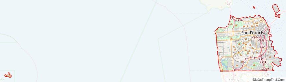
San Francisco County Road Map
Geography
San Francisco is located on the West Coast of the United States at the north end of the San Francisco Peninsula and includes significant stretches of the Pacific Ocean and San Francisco Bay within its boundaries. Several picturesque islands—Alcatraz, Treasure Island and the adjacent Yerba Buena Island, and small portions of Alameda Island, Red Rock Island, and Angel Island—are part of the city. Also included are the uninhabited Farallon Islands, 27 miles (43 km) offshore in the Pacific Ocean. The mainland within the city limits roughly forms a “seven-by-seven-mile square”, a common local colloquialism referring to the city’s shape, though its total area, including water, is nearly 232 square miles (600 km).
There are more than 50 hills within the city limits. Some neighborhoods are named after the hill on which they are situated, including Nob Hill, Potrero Hill, and Russian Hill. Near the geographic center of the city, southwest of the downtown area, are a series of less densely populated hills. Twin Peaks, a pair of hills forming one of the city’s highest points, forms an overlook spot. San Francisco’s tallest hill, Mount Davidson, is 928 feet (283 m) high and is capped with a 103-foot (31 m) tall cross built in 1934. Dominating this area is Sutro Tower, a large red and white radio and television transmission tower reaching 1,811 ft (552 m) above sea level.
The nearby San Andreas and Hayward Faults are responsible for much earthquake activity, although neither physically passes through the city itself. The San Andreas Fault caused the earthquakes in 1906 and 1989. Minor earthquakes occur on a regular basis. The threat of major earthquakes plays a large role in the city’s infrastructure development. The city constructed an auxiliary water supply system and has repeatedly upgraded its building codes, requiring retrofits for older buildings and higher engineering standards for new construction. However, there are still thousands of smaller buildings that remain vulnerable to quake damage. USGS has released the California earthquake forecast which models earthquake occurrence in California.
San Francisco’s shoreline has grown beyond its natural limits. Entire neighborhoods such as the Marina, Mission Bay, and Hunters Point, as well as large sections of the Embarcadero, sit on areas of landfill. Treasure Island was constructed from material dredged from the bay as well as material resulting from the excavation of the Yerba Buena Tunnel through Yerba Buena Island during the construction of the Bay Bridge. Such land tends to be unstable during earthquakes. The resulting soil liquefaction causes extensive damage to property built upon it, as was evidenced in the Marina district during the 1989 Loma Prieta earthquake. A few natural lakes and creeks (Lake Merced, Mountain Lake, Pine Lake, Lobos Creek, El Polin Spring) are within parks and remain protected in what is essentially their original form, but most of the city’s natural watercourses, such as Islais Creek and Mission Creek, have been partially or completely culverted and built over. Since the 1990s, however, the Public Utilities Commission has been studying proposals to daylight or restore some creeks.
Cityscape
The historic center of San Francisco is the northeast quadrant of the city anchored by Market Street and the waterfront. It is here that the Financial District is centered, with Union Square, the principal shopping and hotel district, and the Tenderloin nearby. Cable cars carry riders up steep inclines to the summit of Nob Hill, once the home of the city’s business tycoons, and down to the waterfront tourist attractions of Fisherman’s Wharf, and Pier 39, where many restaurants feature Dungeness crab from a still-active fishing industry. Also in this quadrant are Russian Hill, a residential neighborhood with the famously crooked Lombard Street; North Beach, the city’s Little Italy and the former center of the Beat Generation; and Telegraph Hill, which features Coit Tower. Abutting Russian Hill and North Beach is San Francisco’s Chinatown, the oldest Chinatown in North America. The South of Market, which was once San Francisco’s industrial core, has seen significant redevelopment following the construction of Oracle Park and an infusion of startup companies. New skyscrapers, live-work lofts, and condominiums dot the area. Further development is taking place just to the south in Mission Bay area, a former railroad yard, which now has a second campus of the University of California, San Francisco and Chase Center, which opened in 2019 as the new home of the Golden State Warriors.
West of downtown, across Van Ness Avenue, lies the large Western Addition neighborhood, which became established with a large African American population after World War II. The Western Addition is usually divided into smaller neighborhoods including Hayes Valley, the Fillmore, and Japantown, which was once the largest Japantown in North America but suffered when its Japanese American residents were forcibly removed and interned during World War II. The Western Addition survived the 1906 earthquake with its Victorians largely intact, including the famous “Painted Ladies”, standing alongside Alamo Square. To the south, near the geographic center of the city is Haight-Ashbury, famously associated with 1960s hippie culture. The Haight is now home to some expensive boutiques and a few controversial chain stores, although it still retains some bohemian character.
North of the Western Addition is Pacific Heights, an affluent neighborhood that features the homes built by wealthy San Franciscans in the wake of the 1906 earthquake. Directly north of Pacific Heights facing the waterfront is the Marina, a neighborhood popular with young professionals that was largely built on reclaimed land from the Bay.
In the southeast quadrant of the city is the Mission District—populated in the 19th century by Californios and working-class immigrants from Germany, Ireland, Italy, and Scandinavia. In the 1910s, a wave of Central American immigrants settled in the Mission and, in the 1950s, immigrants from Mexico began to predominate. In recent years, gentrification has changed the demographics of parts of the Mission from Latino, to twenty-something professionals. Noe Valley to the southwest and Bernal Heights to the south are both increasingly popular among young families with children. East of the Mission is the Potrero Hill neighborhood, a mostly residential neighborhood that features sweeping views of downtown San Francisco. West of the Mission, the area historically known as Eureka Valley, now popularly called the Castro, was once a working-class Scandinavian and Irish area. It has become North America’s first gay village, and is now the center of gay life in the city. Located near the city’s southern border, the Excelsior District is one of the most ethnically diverse neighborhoods in San Francisco. The predominantly African American Bayview-Hunters Point in the far southeast corner of the city is one of the poorest neighborhoods and suffers from a high rate of crime, though the area has been the focus of several revitalizing and controversial urban renewal projects.
The construction of the Twin Peaks Tunnel in 1918 connected southwest neighborhoods to downtown via streetcar, hastening the development of West Portal, and nearby affluent Forest Hill and St. Francis Wood. Further west, stretching all the way to the Pacific Ocean and north to Golden Gate Park lies the vast Sunset District, a large middle-class area with a predominantly Asian population.
The northwestern quadrant of the city contains the Richmond, a mostly middle-class neighborhood north of Golden Gate Park, home to immigrants from other parts of Asia as well as many Russian and Ukrainian immigrants. Together, these areas are known as The Avenues. These two districts are each sometimes further divided into two regions: the Outer Richmond and Outer Sunset can refer to the more western portions of their respective district and the Inner Richmond and Inner Sunset can refer to the more eastern portions.
Many piers remained derelict for years until the demolition of the Embarcadero Freeway reopened the downtown waterfront, allowing for redevelopment. The centerpiece of the port, the Ferry Building, while still receiving commuter ferry traffic, has been restored and redeveloped as a gourmet marketplace.
Climate
San Francisco has a warm-summer Mediterranean climate (Köppen Csb) characteristic of California’s coast, with moist, mild winters and dry summers. San Francisco’s weather is strongly influenced by the cool currents of the Pacific Ocean on the west side of the city, and the water of San Francisco Bay to the north and east. This moderates temperature swings and produces a remarkably mild year-round climate with little seasonal temperature variation.
Among major U.S. cities, San Francisco has the coolest daily mean, maximum, and minimum temperatures for June, July, and August. During the summer, rising hot air in California’s interior valleys creates a low-pressure area that draws winds from the North Pacific High through the Golden Gate, which creates the city’s characteristic cool winds and fog. The fog is less pronounced in eastern neighborhoods and during the late summer and early fall. As a result, the year’s warmest month, on average, is September, and on average, October is warmer than July, especially in daytime.
Temperatures reach or exceed 80 °F (27 °C) on an average of only 21 and 23 days a year at downtown and San Francisco International Airport (SFO), respectively. The dry period of May to October is mild to warm, with the normal monthly mean temperature peaking in September at 62.7 °F (17.1 °C). The rainy period of November to April is slightly cooler, with the normal monthly mean temperature reaching its lowest in January at 51.3 °F (10.7 °C). On average, there are 73 rainy days a year, and annual precipitation averages 23.65 inches (601 mm). Variation in precipitation from year to year is high. Above-average rain years are often associated with warm El Niño conditions in t


