Map of Altheimer city

Map of Altheimer city

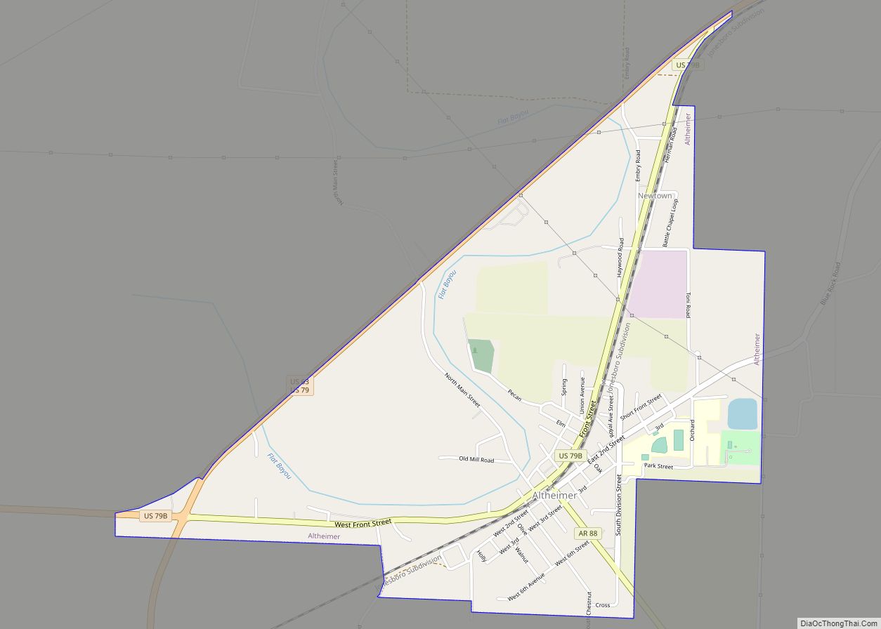
Altheimer is a city in Plum Bayou Township, Jefferson County, Arkansas. It is situated on the Union Pacific Railway, 11 miles (18 km) northeast of Pine Bluff. As of the 2010 census it had a population of 984, down from 1,192 at the 2000 census. As of 2018 the estimated population was 829. Altheimer city overview: … Read more

Map of Alpena town

Map of Alpena town, Arkansas

Alpena /ælˈpiːnə/ is a town in Boone and Carroll counties in the U.S. state of Arkansas. The population was 374 at the 2020 census. The Boone County portion of Alpena is part of the Harrison Micropolitan Statistical Area. Alpena town overview: Name: Alpena town LSAD Code: 43 LSAD Description: town (suffix) State: Arkansas County: Boone … Read more

Map of Anthonyville town

Map of Anthonyville town

Anthonyville is a town in Crittenden County, Arkansas, United States. The population was 161 at the 2010 census, down from 250 in 2000. Anthonyville town overview: Name: Anthonyville town LSAD Code: 43 LSAD Description: town (suffix) State: Arkansas County: Crittenden County Elevation: 203 ft (62 m) Total Area: 0.08 sq mi (0.20 km²) Land Area: 0.08 sq mi (0.20 km²) Water Area: 0.00 sq mi … Read more

Map of Amity city

Map of Amity city, Arkansas

Amity is a city in Clark County, Arkansas, United States. The population was 723 at the 2010 census. The city began on the Caddo River in the mid-19th century when William F. Browning and others, including A.B. Clingman, at various times moved to the area. Amity city overview: Name: Amity city LSAD Code: 25 LSAD … Read more

Map of Amagon town

Map of Amagon town

Amagon is a town in Jackson County, Arkansas, United States. The population was 98 at the 2010 census. Amagon is the birthplace of former Arkansas Governor Mike Beebe. Amagon town overview: Name: Amagon town LSAD Code: 43 LSAD Description: town (suffix) State: Arkansas County: Jackson County Elevation: 223 ft (68 m) Total Area: 0.11 sq mi (0.29 km²) Land Area: … Read more

Map of Arkansas City city

Map of Arkansas City, Arkansas

Arkansas City is a town in Desha County, Arkansas, United States. The population was 366 at the 2010 census. The town is the county seat of Desha County. Arkansas City’s historic Commercial District, located at Desoto Avenue and Sprague Street, is listed on the National Register of Historic Places. Arkansas City overview: Name: Arkansas City … Read more

Map of Arkadelphia city

Map of Arkadelphia city

Arkadelphia is a city in Clark County, Arkansas, United States. As of the 2020 census, the population was 10,380. The city is the county seat of Clark County. It is situated at the foothills of the Ouachita Mountains. Two universities, Henderson State University and Ouachita Baptist University, are located here. Arkadelphia was incorporated in 1857. … Read more

Map of Antoine town

Map of Antoine town

Antoine is a town in Pike County, Arkansas, United States, along the Antoine River. The population was 117 according to the 2010 census. Antoine town overview: Name: Antoine town LSAD Code: 43 LSAD Description: town (suffix) State: Arkansas County: Pike County Elevation: 299 ft (91 m) Total Area: 0.51 sq mi (1.33 km²) Land Area: 0.51 sq mi (1.31 km²) Water Area: 0.01 sq mi … Read more

Map of Atkins city

Map of Atkins city, Arkansas

Atkins is a city in Pope County, Arkansas, United States. The population was 3,016 at the 2010 census. It is part of the Russellville Micropolitan Statistical Area. Atkins city overview: Name: Atkins city LSAD Code: 25 LSAD Description: city (suffix) State: Arkansas County: Pope County Elevation: 367 ft (112 m) Total Area: 6.14 sq mi (15.89 km²) Land Area: 6.13 sq mi … Read more

Map of Ashdown city

Map of Ashdown city

Ashdown (formerly Turkey Flats and Keller) is a city in Little River County, Arkansas, United States. The community was incorporated in 1892 and has been the county seat since 1906. Located within the Arkansas Timberlands between the Little River and the Red River, Ashdown’s economy and development have historically been tied to the timber industry. … Read more

Map of Ash Flat city

Map of Ash Flat city

Ash Flat is a city in Fulton and Sharp counties in the U.S. state of Arkansas. with a population of 1,109 in 2021 Ash Flat city overview: Name: Ash Flat city LSAD Code: 25 LSAD Description: city (suffix) State: Arkansas County: Fulton County, Sharp County Elevation: 643 ft (196 m) Total Area: 6.32 sq mi (16.36 km²) Land Area: 6.32 sq mi … Read more

Map of Austin city

Map of Austin city, Arkansas

Austin is a city in Lonoke County, Arkansas, United States. The population was 2,038 as of the 2010 census and an estimated 3,693 as of 2018. It is part of the Little Rock–North Little Rock–Conway Metropolitan Statistical Area. Austin city overview: Name: Austin city LSAD Code: 25 LSAD Description: city (suffix) State: Arkansas County: Lonoke … Read more