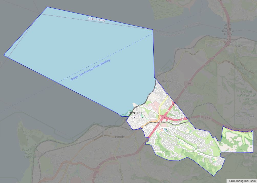
Map of Hidden Hills city

Map of Hidden Hills city

Hidden Hills is a city and gated community in the Santa Monica Mountains region of Los Angeles County, California. It is located next to the city of Calabasas. It is notable for being home to many actors and celebrities. The population was 1,725 at the 2020 census. Hidden Hills city overview: Name: Hidden Hills city … Read more

Map of Hickman CDP

Map of Hickman CDP, California

Hickman is a census-designated place (CDP) in Stanislaus County, California, United States. The population was 641 at the 2010 census, up from 457 at the 2000 census. It is part of the Modesto Metropolitan Statistical Area. Its history dates back to the goldrush era, and was once was a stop on a rail line (the … Read more

Map of Hesperia city

Map of Hesperia city, California

Hesperia is a city in San Bernardino County, California, United States. It is located 35 miles (56 km) north of downtown San Bernardino in Victor Valley and surrounded by the Mojave Desert. Because of its relatively high elevation and the unique and moderate weather patterns of the region, Hesperia is part of what is locally called … Read more

Map of Highgrove CDP

Map of Highgrove CDP

Highgrove is a census-designated place (CDP) and an unincorporated community in Riverside County, California, United States. The population was 3,988 at the 2010 census, up from 3,445 at the 2000 census. The latest 2020 census shows 7,515 total population, an 88.4% increase from last 2010 census, which makes it the fastest-growing location in entire Riverside … Read more

Map of Hidden Valley Lake CDP

Map of Hidden Valley Lake CDP

Hidden Valley Lake is a census-designated place (CDP) and gated subdivision in Lake County, California, United States. The population was 6,235 at the 2020 census, up from 5,579 at the 2010 census. Today, it is a CID (Common Interest Development) known as Hidden Valley Lake Association (HVLA). Hidden Valley Lake CDP overview: Name: Hidden Valley … Read more

Map of Hidden Meadows CDP

Map of Hidden Meadows CDP

Hidden Meadows is a census-designated place (CDP) near Escondido in San Diego County, California. The population was 3,485 at the 2010 census, up from 3,463 at the 2000 census. Hidden Meadows CDP overview: Name: Hidden Meadows CDP LSAD Code: 57 LSAD Description: CDP (suffix) State: California County: San Diego County Elevation: 1,496 ft (456 m) Total Area: … Read more

Map of Hillsborough town

Map of Hillsborough town, California

Hillsborough is an incorporated town in San Mateo County, California, in the San Francisco Bay Area. It is located 17 miles (27 km) south of San Francisco on the San Francisco Peninsula, bordered by Burlingame to the north, San Mateo to the east, Highlands-Baywood Park to the south, and Interstate 280 to the west. The population … Read more

Map of Highlands-Baywood Park CDP

Map of Highlands-Baywood Park CDP

Highlands-Baywood Park is an unincorporated community in San Mateo County, California, United States. The population was 4,027 at the 2010 census. Highlands-Baywood Park CDP overview: Name: Highlands-Baywood Park CDP LSAD Code: 57 LSAD Description: CDP (suffix) State: California County: San Mateo County Total Area: 1.807 sq mi (4.681 km²) Land Area: 1.807 sq mi (4.681 km²) Water Area: 0 sq mi (0 km²)  0% … Read more

Map of Highland city, California

Map of Highland city, California

Highland (and neighboring “East Highlands”) is a city in San Bernardino County, California, United States. The city’s population was 53,104 as of the 2010 census, up from 44,605 in 2000. Highland also refers to a physical section of San Bernardino (usually east of Del Rosa Avenue to the city boundaries) as well as areas of … Read more

Map of Hollister city

Map of Hollister city, California

Hollister is a city in and the county seat of San Benito County, located in the Central Coast region of California. With a 2020 United States census population of 41,678, Hollister is one of the largest cities in the Monterey Bay Area and a member of the Association of Monterey Bay Area Governments. The city … Read more

Map of Hiouchi CDP

Map of Hiouchi CDP

Hiouchi (Tolowa: Xaa-yuu-chit) is a census-designated place in Del Norte County, California. It is located on the Smith River 7.5 miles (12 km) east-northeast of Crescent City, at an elevation of 171 feet (52 m). Its population is 314 as of the 2020 census, up from 301 from the 2010 census. Hiouchi CDP overview: Name: Hiouchi … Read more

Map of Hilmar-Irwin CDP

Map of Hilmar-Irwin CDP

Hilmar-Irwin is a census-designated place (CDP) in Merced County, California, United States. As of the 2020 census, the population was 5,164. Hilmar-Irwin CDP overview: Name: Hilmar-Irwin CDP LSAD Code: 57 LSAD Description: CDP (suffix) State: California County: Merced County Total Area: 3.928 sq mi (10.173 km²) Land Area: 3.928 sq mi (10.173 km²) Water Area: 0 sq mi (0 km²)  0% Total Population: 5,164 … Read more