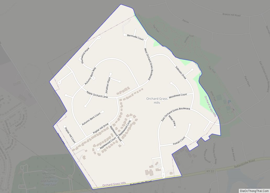
Map of Oneida CDP, Kentucky

Map of Oneida CDP, Kentucky

Oneida is an unincorporated community and census-designated place (CDP) in Clay County, Kentucky, United States. Its population was 410 at the 2010 census. It is the home of Oneida Baptist Institute. Goose Creek, the Red Bird River, and Bullskin Creek confluence to form the South Fork of the Kentucky River a few hundred yards from … Read more

Map of Paducah city

Map of Paducah city, Kentucky

Paducah (/pəˈduːkə/ pə-DOO-kə) is a home rule-class city in and the county seat of McCracken County, Kentucky, United States. The largest city in the Jackson Purchase region, it is located at the confluence of the Tennessee and the Ohio rivers, halfway between St. Louis, Missouri, to the northwest and Nashville, Tennessee, to the southeast. As … Read more

Map of Owingsville city

Map of Owingsville city

Owingsville is a home rule-class city in Bath County, Kentucky, in the United States. The population was 1,530 during the year 2010 U.S. Census. It is the county seat and is located roughly at the county’s center, at the junction of US 60 and Kentucky 36. It is part of the Mount Sterling micropolitan area. … Read more

Map of Owenton city

Map of Owenton city

Owenton is a home rule-class city in and the county seat of Owen County, Kentucky, United States. The population was 1,327 at the 2010 census. It is located at the junction of U.S. Route 127 and Kentucky Route 22, about halfway between Louisville and Cincinnati. Owenton city overview: Name: Owenton city LSAD Code: 25 LSAD … Read more

Map of Paintsville city

Map of Paintsville city

Paintsville (locally /ˈpeɪntsvəl/) is a home rule-class city along Paint Creek in Johnson County, Kentucky, in the United States. It is the seat of its county. The population was 6,459 during the 2010 U.S. Census. Paintsville city overview: Name: Paintsville city LSAD Code: 25 LSAD Description: city (suffix) State: Kentucky County: Johnson County Incorporated: February … Read more

Map of Park City, Kentucky

Map of Park City, Kentucky

Park City is a home rule-class city in Barren County, Kentucky, United States. The population was 537 at the 2010 census. It has served as the historical entrance to nearby Mammoth Cave National Park and to Diamond Caverns, a privately owned cave attraction. Park City is part of the Glasgow micropolitan area. Park City overview: … Read more

Map of Paris city, Kentucky

Map of Paris city, Kentucky

Paris is a home rule-class city in Bourbon County, Kentucky. It lies 18 miles (29 km) northeast of Lexington on the Stoner Fork of the Licking River. Paris is the seat of its county and forms part of the Lexington–Fayette Metropolitan Statistical Area. As of 2020, it had a population of 10,171. Paris city overview: Name: … Read more

Map of Pathfork CDP

Map of Pathfork CDP

Pathfork is an unincorporated community and census-designated place (CDP) in Harlan County, Kentucky, United States, located to the south bank of Wallins Creek. Its population was 379 as of the 2010 census. The community’s main roads are East Hwy 72, which connects from US 119, and travels to an end at Old RB Mines, however, … Read more

Map of Parkway Village city

Map of Parkway Village city

Parkway Village is a home rule-class city in Jefferson County, Kentucky, United States, and a part of the Louisville Metro government. It was developed in the 1920s and incorporated in 1941. The population was 650 at the 2010 census. Parkway Village city overview: Name: Parkway Village city LSAD Code: 25 LSAD Description: city (suffix) State: … Read more

Map of Park Hills city

Map of Park Hills city, Kentucky

Park Hills is a home rule-class city in Kenton County, Kentucky, United States. The population was 3,162 at the 2020 census. It is a suburb of the Cincinnati metropolitan area. Much of the city was listed on the National Register of Historic Places in 2008 as the Park Hills Historic District. Park Hills city overview: … Read more

Map of Perryville city, Kentucky

Map of Perryville city, Kentucky

Perryville (/ˈpɛrɪvəl, -vɪl/) is a home rule-class city along the Chaplin River in western Boyle County, Kentucky, in the United States. The population was 751 at the time of the 2010 U.S. Census. It is part of the Danville Micropolitan Statistical Area. Perryville city overview: Name: Perryville city LSAD Code: 25 LSAD Description: city (suffix) … Read more

Map of Pembroke city, Kentucky

Map of Pembroke city, Kentucky

Pembroke is a home rule-class city in Christian County, Kentucky, in the United States. The population was 869 as of the 2010 U.S. Census. It is part of the Clarksville, Tennessee metropolitan area. Pembroke city overview: Name: Pembroke city LSAD Code: 25 LSAD Description: city (suffix) State: Kentucky County: Christian County Incorporated: 1869 Elevation: 587 ft … Read more