Map of Greensboro town, Maryland

Map of Greensboro town, Maryland

Greensboro is a town located on the banks of the Choptank River in Caroline County, Maryland, United States. The population was 1,931 at the 2010 United States Census. The ZIP code is 21639. The primary phone exchange is 482 and the area code is 410. The town is served by Maryland Routes 480 and 313. … Read more

Map of Greenbelt city

Map of Greenbelt city

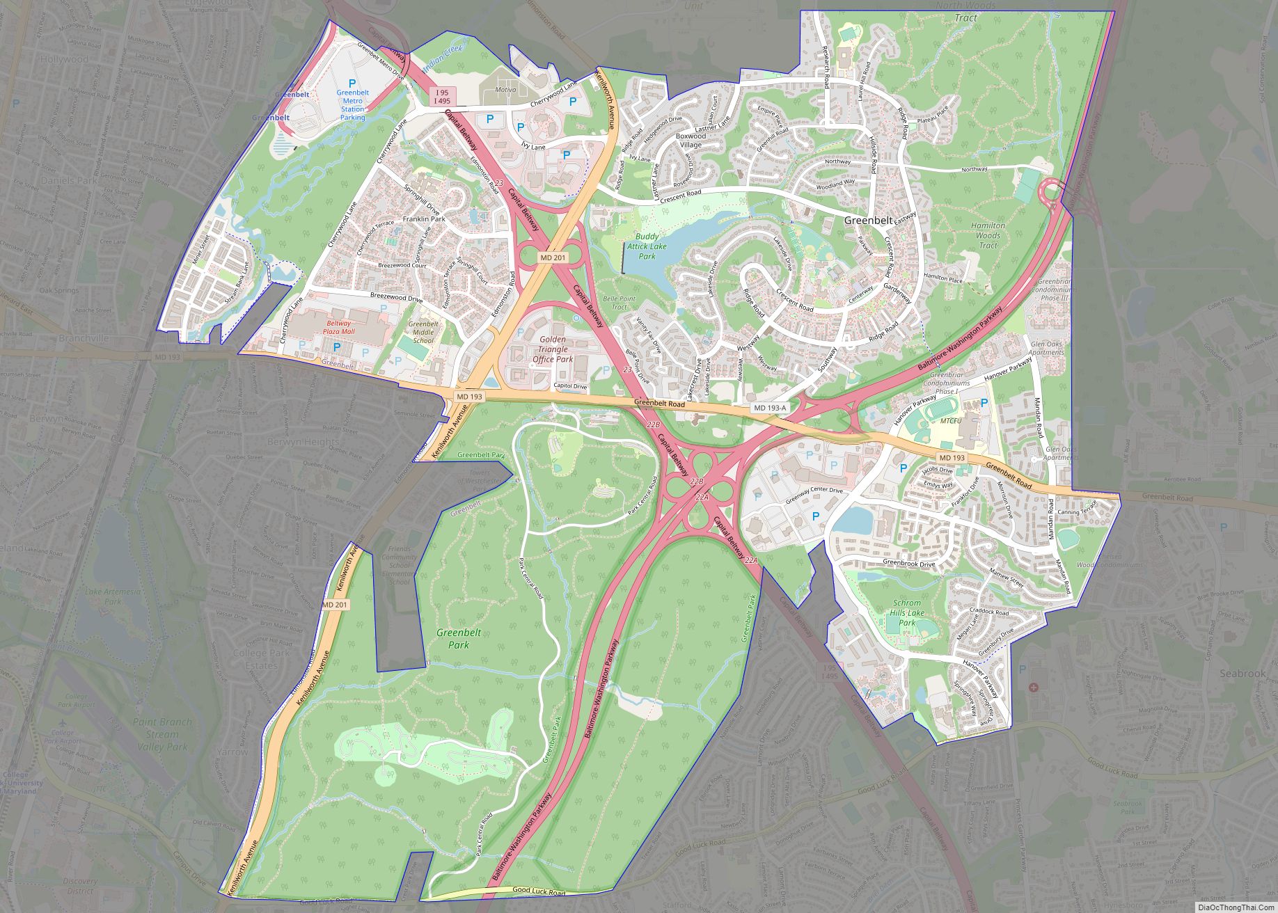
Greenbelt is a city in Prince George’s County, Maryland, United States, and a suburb of Washington, D.C. At the 2020 census, the population was 24,921. Greenbelt is the first and the largest of the three experimental and controversial New Deal Greenbelt Towns, the others being Greenhills, Ohio, and Greendale, Wisconsin. Greenbelt was planned and built … Read more

Map of Grasonville CDP

Map of Grasonville CDP

Grasonville is a census-designated place (CDP) in Queen Anne’s County, Maryland, United States. The population was 2,193 at the 2000 census. Grasonville CDP overview: Name: Grasonville CDP LSAD Code: 57 LSAD Description: CDP (suffix) State: Maryland County: Queen Anne’s County Elevation: 16 ft (5 m) Total Area: 6.29 sq mi (16.29 km²) Land Area: 5.53 sq mi (14.32 km²) Water Area: 0.76 sq mi (1.97 km²) … Read more

Map of Halfway CDP

Map of Halfway CDP, Maryland

Halfway is a census-designated place (CDP) in Washington County, Maryland, United States. The population was 11,896 at the 2020 census. It is named due to its location, which is halfway between Hagerstown and Williamsport. As a major suburb of Hagerstown, Halfway is part of the Hagerstown-Martinsburg, MD-WV, Metropolitan Statistical Area. Halfway CDP overview: Name: Halfway … Read more

Map of Hagerstown city, Maryland

Map of Hagerstown city, Maryland

Hagerstown (/ˈheɪɡərztaʊn/; HAY-gərz-town) is a city in and the county seat of Washington County, Maryland, United States. The population was 43,527 at the 2020 census. Hagerstown ranks as Maryland’s sixth-largest incorporated city and is the largest city in the Maryland Panhandle. Hagerstown anchors the Hagerstown metropolitan area extending into West Virginia. It lies just northwest … Read more

Map of Greensburg CDP, Maryland

Map of Greensburg CDP, Maryland

Greensburg is an unincorporated community and census-designated place in Washington County, Maryland, United States. Its population was 229 as of the 2010 census. Greensburg CDP overview: Name: Greensburg CDP LSAD Code: 57 LSAD Description: CDP (suffix) State: Maryland County: Washington County Total Area: 0.40 sq mi (1.05 km²) Land Area: 0.40 sq mi (1.05 km²) Water Area: 0.00 sq mi (0.00 km²) Total Population: … Read more

Map of Hampton CDP, Maryland

Map of Hampton CDP, Maryland

Hampton is an unincorporated community and census-designated place (CDP) in Baltimore County, Maryland, United States. The population was 5,052 at the 2010 census. Hampton is often considered a subdivision of the nearby community of Towson and is located just north of Baltimore, about twenty minutes from downtown. Hampton contains residences situated on lots up to … Read more

Map of Hampstead town

Map of Hampstead town, Maryland

Hampstead is a town in Carroll County in the U.S. state of Maryland. The population was 6,323 at the 2010 census. Hampstead town overview: Name: Hampstead town LSAD Code: 43 LSAD Description: town (suffix) State: Maryland County: Carroll County Incorporated: 1888 Elevation: 928 ft (283 m) Total Area: 3.33 sq mi (8.62 km²) Land Area: 3.30 sq mi (8.55 km²) Water Area: 0.03 sq mi … Read more

Map of Hancock town, Maryland

Map of Hancock town, Maryland

Hancock is a town in Washington County, Maryland, United States. The population was 1,557 at the 2020 census. The Western Maryland community is notable for being located at the narrowest part of the state. The north–south distance from the Pennsylvania state line to the West Virginia state line is only 1.8 miles (2.9 km) at Hancock. … Read more

Map of Henderson town, Maryland

Map of Henderson town, Maryland

Henderson is a town in Caroline County, Maryland, United States. The population was 146 at the 2010 United States Census. It was named for a stockholder of the Delaware and Chesapeake Railroad. Athol was listed on the National Register of Historic Places in 1989. Henderson town overview: Name: Henderson town LSAD Code: 43 LSAD Description: … Read more

Map of Hebron town, Maryland

Map of Hebron town, Maryland

Hebron is a town in Wicomico County, Maryland, United States. The population was 1,084 at the 2010 census. It is included in the Salisbury, Maryland-Delaware Metropolitan Statistical Area. It is the hometown of pro-wrestler Mark Hildreth and politician Scott Taylor. Hebron town overview: Name: Hebron town LSAD Code: 43 LSAD Description: town (suffix) State: Maryland … Read more

Map of Havre de Grace city

Map of Havre de Grace city

Havre de Grace (/hævər dɪˈɡreɪs/), abbreviated HdG, is a city in Harford County, Maryland. It is situated at the mouth of the Susquehanna River and the head of Chesapeake Bay. It is named after the port city of Le Havre, France, which in full was once Le Havre de Grâce (French, “Harbor of Grace”). The … Read more