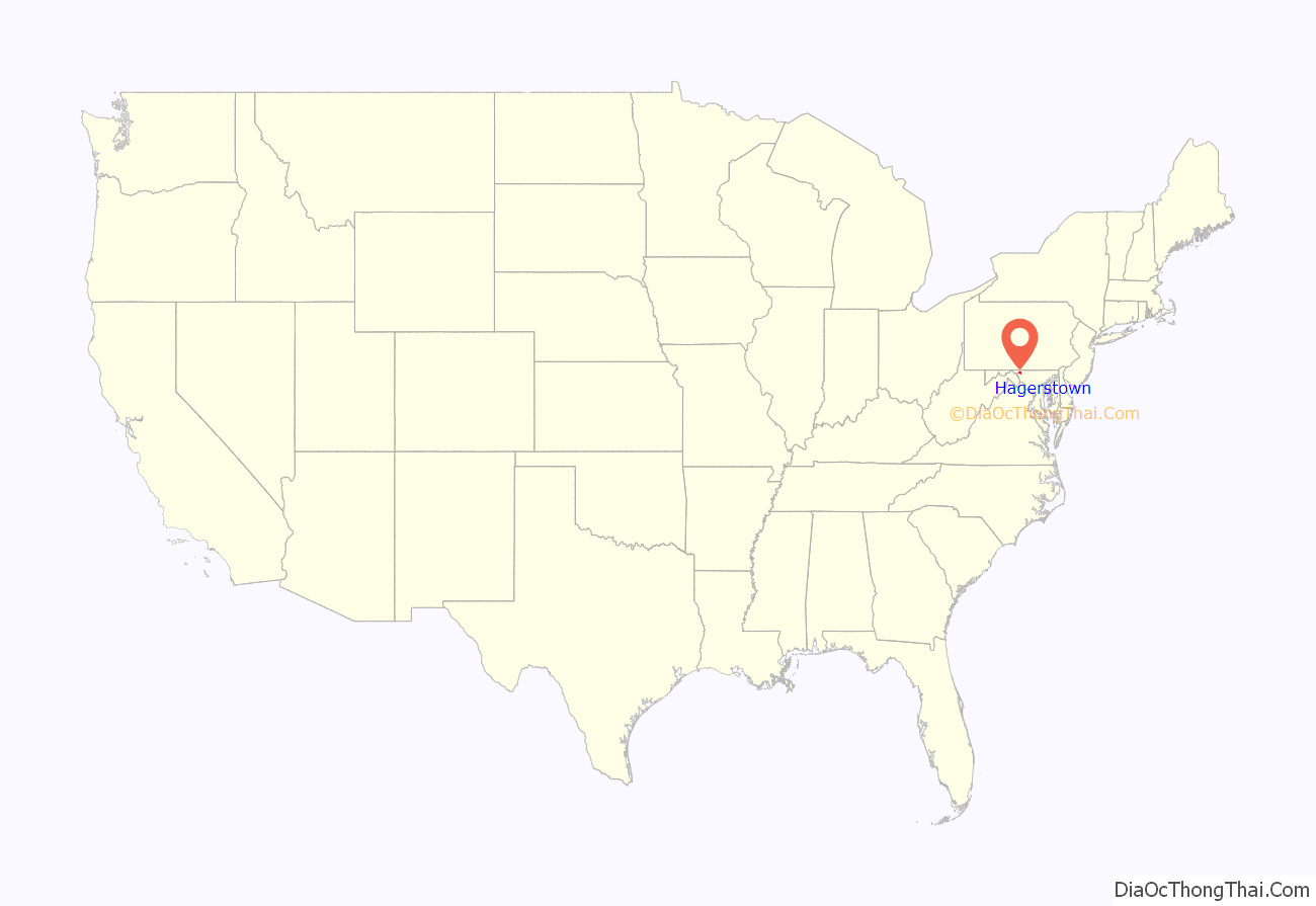
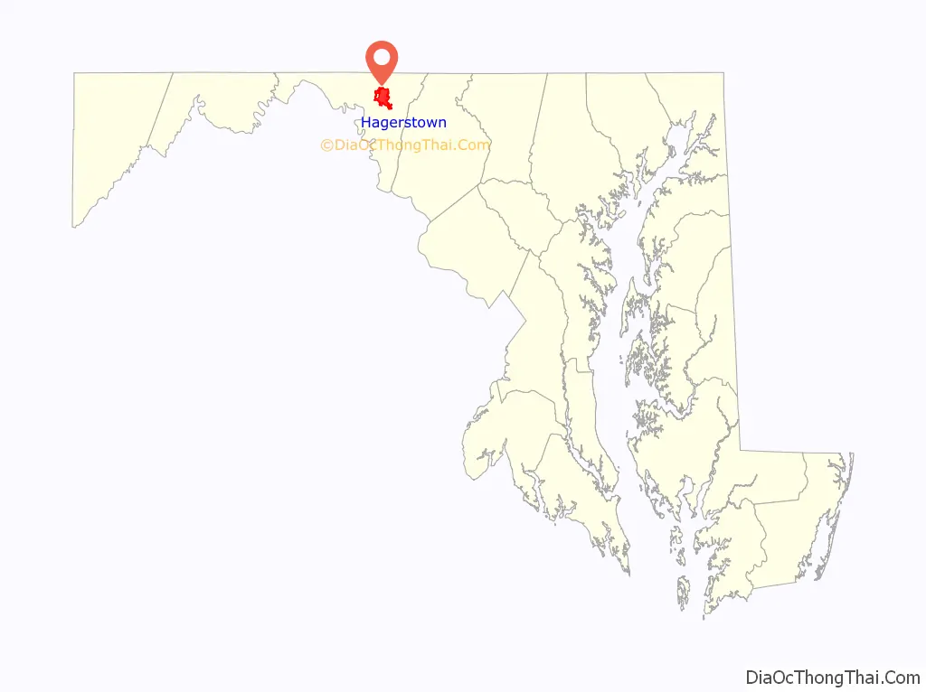
Hagerstown (/ˈheɪɡərztaʊn/; HAY-gərz-town) is a city in and the county seat of Washington County, Maryland, United States. The population was 43,527 at the 2020 census. Hagerstown ranks as Maryland’s sixth-largest incorporated city and is the largest city in the Maryland Panhandle.
Hagerstown anchors the Hagerstown metropolitan area extending into West Virginia. It lies just northwest of the Washington–Baltimore combined statistical area in the heart of the Great Appalachian Valley. The population of the metropolitan area in 2020 was 293,844. Greater Hagerstown was the fastest-growing metropolitan area in the state of Maryland and among the fastest growing in the United States, as of 2009.
Hagerstown has a distinct topography, formed by stone ridges running from northeast to southwest through the center of town. Geography accordingly bounds its neighborhoods. These ridges consist of upper Stonehenge Limestone. Many of the older buildings were built from this stone, which is easily quarried and dressed onsite. It whitens in weathering and the edgewise conglomerate and wavy laminae become distinctly visible, giving an appearance unique to the Cumberland Valley as seen in the architecture of St. John’s Episcopal Church.
Despite its semi-rural Western Maryland setting, Hagerstown is a center of transit and commerce. Interstates 81 and 70, CSX, Norfolk Southern, and the Winchester and Western railroads, as well as Hagerstown Regional Airport form an extensive transportation network for the city. Hagerstown is also the chief commercial and industrial hub for a greater Tri-State Area that includes much of Western Maryland as well as significant portions of South Central Pennsylvania and the Eastern Panhandle of West Virginia. Hagerstown has often been referred to as, and is nicknamed, the Hub City.
| Name: | Hagerstown city |
|---|---|
| LSAD Code: | 25 |
| LSAD Description: | city (suffix) |
| State: | Maryland |
| County: | Washington County |
| Founded: | 1762 |
| Incorporated: | 1813 |
| Elevation: | 538 ft (164 m) |
| Land Area: | 12.55 sq mi (32.51 km²) |
| Water Area: | 0.01 sq mi (0.03 km²) |
| Population Density: | 3,467.18/sq mi (1,338.71/km²) |
| Area code: | 301, 240 |
| FIPS code: | 2436075 |
| GNISfeature ID: | 0598385 |
| Website: | www.hagerstownmd.org |
Online Interactive Map
Click on ![]() to view map in "full screen" mode.
to view map in "full screen" mode.
Hagerstown location map. Where is Hagerstown city?
History
Founding
In 1739, Jonathan Hager, a German immigrant from Pennsylvania and a volunteer Captain of Scouts, purchased 200 acres (81 ha) of land in the Great Appalachian Valley between the Blue Ridge and Allegheny Mountains in Maryland and called it Hager’s Fancy. In 1762, Hager officially founded the town of Elizabethtown which he named after his wife, Elizabeth Kershner. Fourteen years later, Jonathan Hager became known as the “Father of Washington County” after his efforts helped Hagerstown become the county seat of newly created Washington County, which Hager also helped create from neighboring Frederick County. The City Council changed the community’s name to Hager’s-Town in 1813 because the name had gained popular usage, and in the following year, the Maryland State Legislature officially endorsed the changing of the town’s name.
In 1794, government forces arrested 150 citizens during a draft riot which was staged by protesters in response to the Whiskey Rebellion.
American Civil War
Hagerstown’s strategic location at the border between the North and the South made the city a primary staging area and supply center for four major campaigns during the Civil War. In 1861, General Robert Patterson’s troops used Hagerstown as a base to attack Virginia troops in the Shenandoah Valley. In the Maryland Campaign of 1862, General James Longstreet’s command occupied the town while en route to the Battle of South Mountain and Antietam. In 1863, the city was the site of several military incursions and engagements as Gen. Robert E. Lee’s army invaded and retreated in the Gettysburg Campaign. In 1864, Hagerstown was invaded by the Confederate army under Lt. Gen. Jubal Early. On Wednesday, July 6, Early sent 1,500 cavalry, commanded by Brig. Gen. John McCausland, into Hagerstown. The Confederates levied a ransom of $20,000 and a large amount of clothing, in retribution for U.S. destruction of farms, feed and cattle in the Shenandoah Valley. This is in contrast to neighboring Chambersburg, Pennsylvania, which McCausland razed on July 30 when the borough failed to supply the requested ransom of $500,000 in U.S. currency, or $100,000 in gold.
Following the war, in 1872 Maryland and Virginia cooperated to re-inter Confederate dead from their impromptu graves to cemeteries in Hagerstown, Frederick and Shepherdstown, West Virginia. Roughly 60% however, remained unidentified. In 1877, 15 years after the Battle of Antietam, also known as the Battle of Sharpsburg, approximately 2,800 Confederate dead from that battle and also from the battles on South Mountain were re-interred in Washington Confederate Cemetery, within Rose Hill Cemetery in Hagerstown.
Railroads
Hagerstown’s nickname of the “Hub City” originated from the large number of railroads (and roads) that served the city. Hagerstown was the center of the Western Maryland Railway and an important city on the Pennsylvania, Norfolk and Western, Baltimore and Ohio, and Hagerstown and Frederick Railroads. Currently, the city is a vital location on CSX, Norfolk Southern, and the Winchester and Western Railroads.
Hagerstown was formerly served by the Hagerstown & Frederick Railway, an interurban trolley system, from 1896 to 1947.
Little Heiskell
One of the most recognizable symbols of Hagerstown is the weathervane known as “Little Heiskell”. Named after the German tinsmith Benjamin Heiskell who crafted it in 1769 in the form of a Hessian soldier, it stood atop the Market House first and City Hall second for a combined 166 years. It was moved from the Market House to City Hall in 1824.
During the Civil War era, the weathervane gained its characteristic bullet hole from a Confederate sharpshooter, who won a bet after shooting it from a full city block away. In 1935, the original was retired to the Museum of the Washington County Historical Society, later to be moved to its present display in the Jonathan Hager House. An exact replica has replaced it atop City Hall.
The weathervane has been depicted in the city’s annual Mummers Day Parade by Charles Harry Rittenhouse, Sr. sporting the necessary accoutrements of a German mercenary soldier. Little Heiskell was at one time the mascot of North Hagerstown High School.
Aviation heritage
Hagerstown’s first aircraft production came in World War I with the Maryland Pressed Steel Company building the Bellanca CD biplane in hopes of securing government contracts. From 1931 to 1984, Fairchild Aircraft was based in Hagerstown and was by far the area’s most prominent employer. The importance of the company to the city and the country as a whole earned Hagerstown its former nickname “Home of the Flying Boxcar,” after the Fairchild C-119 Flying Boxcar.
Fairchild moved to Hagerstown from Farmingdale, New York, in 1931 after Sherman Fairchild purchased a majority stock interest in Kreider-Reisner Aircraft Company of Hagerstown in 1929. Among Fairchild’s products during World War II were PT-19/PT-23/PT-26 (Cornell) and AT-21 trainers, C-82 “Packet” cargo planes and missiles. At its height in World War II, Fairchild employed directly and indirectly up to 80% of Hagerstown’s workforce or roughly 10,000 people.
In the postwar era, Fairchild continued to produce aircraft in Hagerstown such as C-123 Provider, Fairchild F-27 and Fairchild Hiller FH-227, FH-1100, C-26 Metroliner, UC-26 Metroliner, Fairchild Republic A-10 Thunderbolt II, and the Fairchild T-46 jet trainer.
All production ceased in Hagerstown in 1984 and the company moved elsewhere. Presently, the company is based in San Antonio, Texas, and after a series of mergers and acquisitions, is known as M7 Aerospace.
The Hagerstown Aviation Museum shows many of these original aircraft. Among the ones on display are: 1939 F24/UC-61C, 1945 C-82A, 1943 PT-19A, and the 1953 C-119. The museum is located near Hagerstown Regional Airport in the airport’s former terminal. Hagerstown is also the birthplace of Salisbury, Maryland-based Piedmont Airlines which started out as Henson Aviation. It was founded by Richard A. Henson in 1931. Today, Hagerstown Regional Airport-Richard A. Henson Field is named as such in honor of the airlines’ founder. Today, only small to medium-sized aviation companies remain in the area, e.g., Sierra Nevada Corporation, a defense electronics engineering and manufacturing contractor.
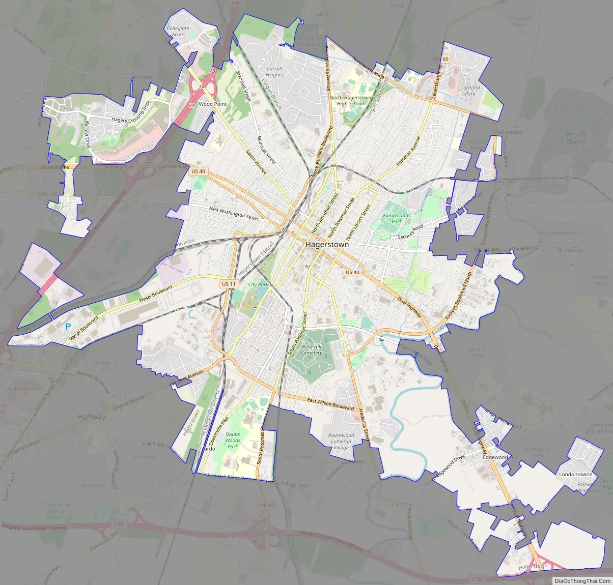
Hagerstown Road Map
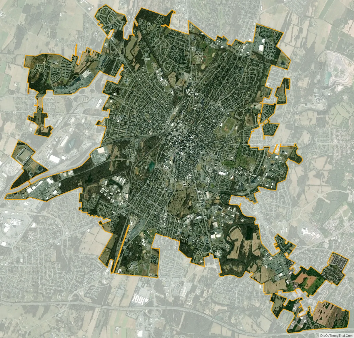
Hagerstown city Satellite Map
Geography
Location and topography
Hagerstown is located at 39°38′34″N 77°43′12″W / 39.64278°N 77.72000°W / 39.64278; -77.72000 (39.642771, −77.719954). It is situated south of the Mason–Dixon line and north of the Potomac River and between the Blue Ridge and Allegheny Mountains in a part of the Great Appalachian Valley known regionally as Cumberland Valley and locally as Hagerstown Valley. The community also lies within proximity of Pennsylvania, West Virginia, and Virginia. Hagerstown, by driving distance, is approximately 70 miles (110 km) northwest of Washington, D.C., 72 miles (116 km) west-northwest of Baltimore and 74 miles (119 km) southwest of Harrisburg, Pennsylvania.
According to the United States Census Bureau, the city has a total area of 11.80 square miles (30.56 km), of which 11.79 square miles (30.54 km) is land and 0.01 square miles (0.03 km) is water. Major waterways within Hagerstown include Hamilton Run and Antietam Creek that are tributaries of the Potomac River. Natural landscape around Hagerstown consists of low, rolling hills with elevations of 500 feet (150 m) to 800 feet (240 m) above sea level and rich, fertile land that is well-suited and utilized for dairy farming, cornfields, and fruit orchards typical of Mid-Atlantic agriculture.
Climate
Hagerstown is situated in the transition between the humid subtropical climate zone (Köppen Cfa) and the humid continental climate zone (Köppen Dfa), with hot, humid summers and cool to moderately cold winters. Normal monthly mean temperatures range from 32.9 °F (0.5 °C) in January to 77.6 °F (25.3 °C) in July, while record temperatures range from −27 °F (−33 °C) on January 13, 1912, up to 107 °F (42 °C) on July 23, 1999. Precipitation is moderate, averaging 39.29 in (998 mm) annually, and is somewhat evenly distributed throughout the year, with a slight winter minimum and a maximum in May and June.
See also
Map of Maryland State and its subdivision: Map of other states:- Alabama
- Alaska
- Arizona
- Arkansas
- California
- Colorado
- Connecticut
- Delaware
- District of Columbia
- Florida
- Georgia
- Hawaii
- Idaho
- Illinois
- Indiana
- Iowa
- Kansas
- Kentucky
- Louisiana
- Maine
- Maryland
- Massachusetts
- Michigan
- Minnesota
- Mississippi
- Missouri
- Montana
- Nebraska
- Nevada
- New Hampshire
- New Jersey
- New Mexico
- New York
- North Carolina
- North Dakota
- Ohio
- Oklahoma
- Oregon
- Pennsylvania
- Rhode Island
- South Carolina
- South Dakota
- Tennessee
- Texas
- Utah
- Vermont
- Virginia
- Washington
- West Virginia
- Wisconsin
- Wyoming


