Map of Midland city, Michigan

Map of Midland city, Michigan

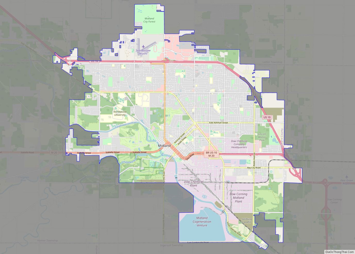
Midland is a city in and the county seat of Midland County, Michigan. The city’s population was 42,547 as of the 2020 census. It is the principal city of the Midland Micropolitan Statistical Area, part of the larger Saginaw-Midland-Bay City Combined Statistical Area. Midland city overview: Name: Midland city LSAD Code: 25 LSAD Description: city … Read more

Map of Montgomery village, Michigan

Map of Montgomery village, Michigan

Montgomery is a village in Hillsdale County in the U.S. state of Michigan. The population was 322 at the 2020 census. The village is located within Camden Township. Montgomery village overview: Name: Montgomery village LSAD Code: 47 LSAD Description: village (suffix) State: Michigan County: Hillsdale County Incorporated: 1906 Elevation: 1,050 ft (320 m) Total Area: 1.00 sq mi (2.60 km²) … Read more

Map of Montague city, Michigan

Map of Montague city, Michigan

Montague is a city in Muskegon County in the U.S. state of Michigan. The population was 2,361 at the 2010 census. The city is located within Montague Township, but is politically independent. The Montague ZIP code 49437 also serves all of Montague Township and White River Township, as well as a small portions of Whitehall … Read more

Map of Monroe city, Michigan

Map of Monroe city, Michigan

Monroe is the largest city and county seat of Monroe County, Michigan, United States. The population was 20,462 as of the 2020 census. The city is bordered on the south by Monroe Charter Township, but the two are administered autonomously. Monroe is the core city in the Monroe metropolitan area, which is coterminous with Monroe … Read more

Map of Mio CDP

Map of Mio CDP

Mio (/ˈmaɪoʊ/ MY-oh) is an unincorporated community and census-designated place (CDP) in Oscoda County in the U.S. state of Michigan. It is the county seat of Oscoda County. The population of the CDP was 1,690 at the 2020 census. Mio is situated along the boundary between Mentor Township on the east, Big Creek Township on … Read more

Map of Minden City village

Map of Minden City village

Minden City is a village in Sanilac County of the U.S. state of Michigan. The population was 197 at the 2010 census. The village is located within Minden Township. It has possessed a post office since 1862 (named Minden until 1883). Minden City village overview: Name: Minden City village LSAD Code: 47 LSAD Description: village … Read more

Map of Mount Clemens city

Map of Mount Clemens city

Mount Clemens is a city in the U.S. state of Michigan. The population was 16,314 at the 2010 census. It is the seat of government of Macomb County. Mount Clemens city overview: Name: Mount Clemens city LSAD Code: 25 LSAD Description: city (suffix) State: Michigan County: Macomb County Elevation: 604 ft (184 m) Total Area: 4.21 sq mi (10.89 km²) … Read more

Map of Morrice village

Map of Morrice village

Morrice is a village located in Shiawassee County in the U.S. state of Michigan. The population was 927 at the 2010 census. The village is located within Perry Township. The center of population of Michigan is located near Morrice. Morrice village overview: Name: Morrice village LSAD Code: 47 LSAD Description: village (suffix) State: Michigan County: … Read more

Map of Morley village, Michigan

Map of Morley village, Michigan

Morley is a village in Deerfield Township, Mecosta County in the U.S. state of Michigan. The population was 493 at the 2010 census. Morley village overview: Name: Morley village LSAD Code: 47 LSAD Description: village (suffix) State: Michigan County: Mecosta County Elevation: 915 ft (279 m) Total Area: 0.99 sq mi (2.56 km²) Land Area: 0.90 sq mi (2.32 km²) Water Area: 0.10 sq mi … Read more

Map of Morenci city, Michigan

Map of Morenci city, Michigan

Morenci is a city in Lenawee County in the U.S. state of Michigan. Sharing a southern boundary with the state of Ohio, it is the southernmost city in the state of Michigan. The population was 2,270 at the 2020 census. Morenci city overview: Name: Morenci city LSAD Code: 25 LSAD Description: city (suffix) State: Michigan … Read more

Map of Montrose city, Michigan

Map of Montrose city, Michigan

Montrose is a city in Genesee County in the U.S. state of Michigan. The population was 1,657 at the 2010 census. Once part of the surrounding Montrose Township, the city itself incorporated in 1980, and both are now administered autonomously. Montrose city overview: Name: Montrose city LSAD Code: 25 LSAD Description: city (suffix) State: Michigan … Read more

Map of Mount Morris city, Michigan

Map of Mount Morris city, Michigan

Mount Morris is a city in Genesee County in the U.S. state of Michigan. The population was 3,086 at the 2010 census. The city is bordered by Mount Morris Township on the west and Genesee Township on the east. It was named after Mount Morris, New York, because many of the early settlers had come … Read more