Map of Byhalia town

Map of Byhalia town

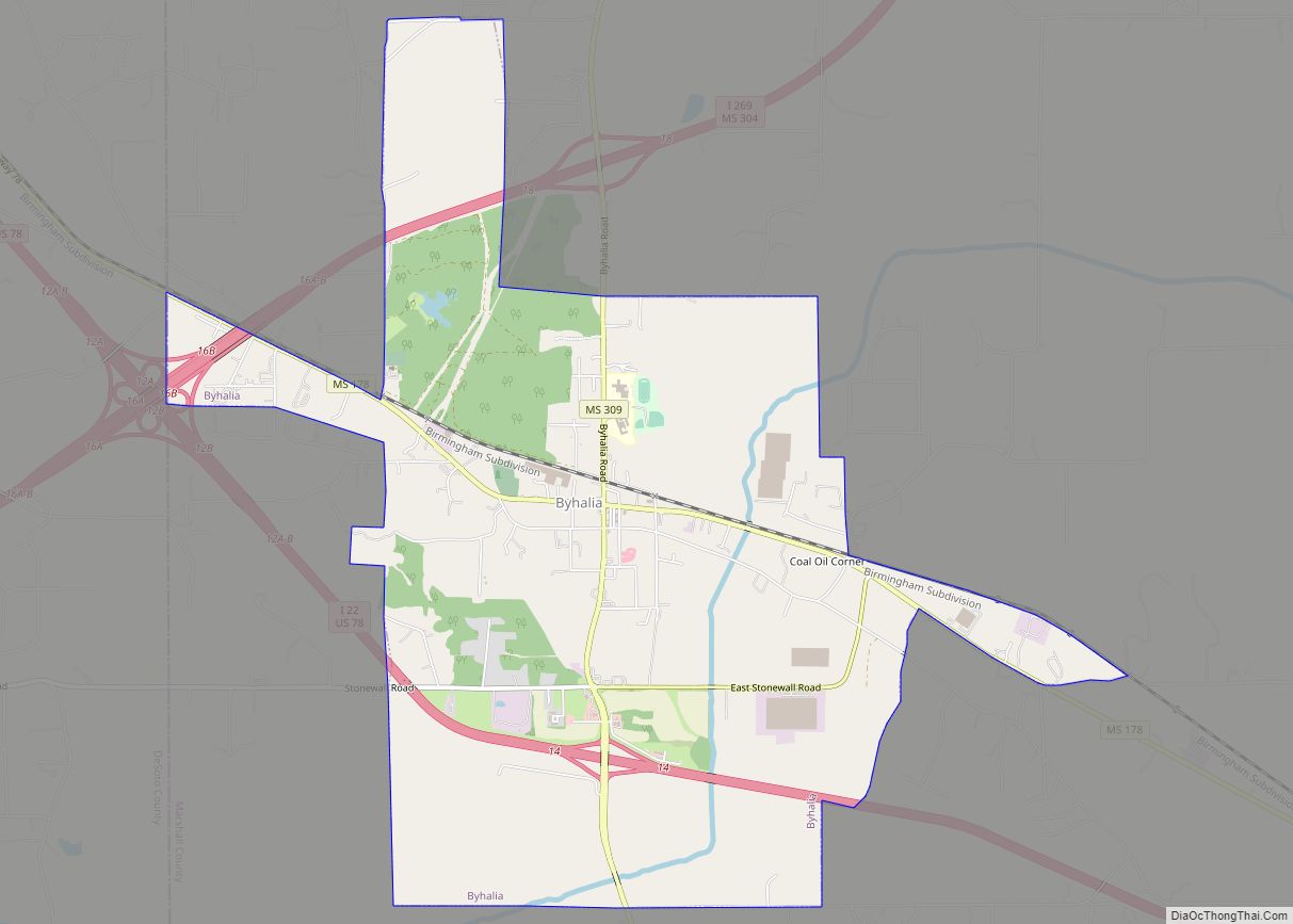
Byhalia /baɪˈheɪljə/ bye-HAIL-yə), is a town in Marshall County, Mississippi, United States. The population was 1,302 as of the 2010 census. Byhalia town overview: Name: Byhalia town LSAD Code: 43 LSAD Description: town (suffix) State: Mississippi County: Marshall County Elevation: 361 ft (110 m) Total Area: 7.19 sq mi (18.62 km²) Land Area: 7.17 sq mi (18.57 km²) Water Area: 0.02 sq mi (0.05 km²) Total … Read more

Map of Burnsville town, Mississippi

Map of Burnsville town, Mississippi

Burnsville is a town in Tishomingo County in northeastern Mississippi, United States. The population was 936 at the 2010 census. Burnsville town overview: Name: Burnsville town LSAD Code: 43 LSAD Description: town (suffix) State: Mississippi County: Tishomingo County Elevation: 463 ft (141 m) Total Area: 4.79 sq mi (12.41 km²) Land Area: 4.77 sq mi (12.36 km²) Water Area: 0.02 sq mi (0.05 km²) Total Population: … Read more

Map of Bude town

Map of Bude town

Bude is a town in Franklin County, Mississippi, United States. The population was 1,063 at the 2010 census. Bude is located on the north bank of the Homochitto River, which bisects the county on a diagonal running from northeast to southwest, where it flows on its way to the Mississippi River. U.S. Routes 98 and … Read more

Map of Carthage city, Mississippi

Map of Carthage city, Mississippi

Carthage is a city in Leake County, Mississippi, United States. The population was 5,075 at the 2010 census. It is the county seat of Leake County. Carthage is home to the Carthage Historic District including the Leake County Courthouse, a Mississippi Landmark. The largest chicken processing plant in the world is located in Carthage. Carthage … Read more

Map of Carrollton town, Mississippi

Map of Carrollton town, Mississippi

Carrollton is a town in and the second county seat of Carroll County, Mississippi, United States, which is within the Mississippi Delta. The population was 190 at the 2010 census, down from 408 in 2000. Centrally located in the county, the town is part of the Greenwood, Mississippi micropolitan area. The first county seat, Vaiden, … Read more

Map of Canton city, Mississippi

Map of Canton city, Mississippi

Canton is a city in Madison County, Mississippi, United States. The population was 13,189 at the 2010 census. It is the county seat of Madison County, and situated in the northern part of the metropolitan area surrounding the state capital, Jackson. Much of Canton is on the National Register of Historic Places. The courthouse square … Read more

Map of Calhoun City town

Map of Calhoun City town

Calhoun City is a town in Calhoun County, Mississippi, United States. The population was 1,774 at the 2010 census. Calhoun City town overview: Name: Calhoun City town LSAD Code: 43 LSAD Description: town (suffix) State: Mississippi County: Calhoun County Elevation: 282 ft (86 m) Total Area: 2.37 sq mi (6.15 km²) Land Area: 2.36 sq mi (6.11 km²) Water Area: 0.02 sq mi (0.04 km²) Total … Read more

Map of Caledonia town, Mississippi

Map of Caledonia town, Mississippi

Caledonia is a town in Lowndes County, Mississippi, United States, northeast of Columbus. The population was 1,041 at the 2010 census. Caledonia town overview: Name: Caledonia town LSAD Code: 43 LSAD Description: town (suffix) State: Mississippi County: Lowndes County Elevation: 335 ft (102 m) Total Area: 2.83 sq mi (7.32 km²) Land Area: 2.83 sq mi (7.32 km²) Water Area: 0.00 sq mi (0.01 km²) Total … Read more

Map of Clara CDP

Map of Clara CDP

Clara is an unincorporated community in Wayne County, Mississippi, United States. It is located at (31.5804410, -88.6964273). The population was 386 at the 2020 census. Clara CDP overview: Name: Clara CDP LSAD Code: 57 LSAD Description: CDP (suffix) State: Mississippi County: Wayne County Total Area: 3.89 sq mi (10.08 km²) Land Area: 3.89 sq mi (10.08 km²) Water Area: 0.00 sq mi (0.00 km²) … Read more

Map of Chunky town

Map of Chunky town

Chunky is a town in Newton County, Mississippi, United States. The population was 344 at the 2000 census. Chunky town overview: Name: Chunky town LSAD Code: 43 LSAD Description: town (suffix) State: Mississippi County: Newton County Elevation: 318 ft (97 m) Total Area: 0.83 sq mi (2.16 km²) Land Area: 0.83 sq mi (2.16 km²) Water Area: 0.00 sq mi (0.00 km²) Total Population: 272 Population … Read more

Map of Charleston city, Mississippi

Map of Charleston city, Mississippi

Charleston is a city in north central Mississippi and one of the two county seats of Tallahatchie County, which is located on both sides of the Tallahatchie River. This city is located east of the river and its population was 2,193 at the 2010 census. Charleston city overview: Name: Charleston city LSAD Code: 25 LSAD … Read more

Map of Centreville town, Mississippi

Map of Centreville town, Mississippi

Centreville is a town in Amite and Wilkinson counties, Mississippi, United States. It is part of the McComb, Mississippi micropolitan statistical area. Its population was 1,258 in 2020. Bethany Presbyterian Church is a historic church in Centreville, built in 1855, and added to the National Register of Historic Places in 2003. The town was incorporated … Read more