Map of Roosevelt borough, New Jersey
Roosevelt is a borough in western Monmouth County, in the U.S. state of New Jersey. As of the 2020 United States census, the borough’s population was 808, a decrease of 74 (−8.4%) from the 2010 census count of 882, which in turn reflected a decline of 51 (−5.5%) from the 933 counted at the 2000 ... Read more
Map of Roosevelt borough, New Jersey
Map of Roebling CDP
Roebling is an unincorporated community and census-designated place (CDP) located within Florence Township, in Burlington County, New Jersey, United States, that was established as part of the 2010 United States census. As of the 2000 United States census, the CDP was combined as Florence-Roebling, which had a total population of 8,200. As of the 2010 ... Read more
Map of Roebling CDP
Map of Rocky Hill borough
Rocky Hill is a borough in Somerset County, in the U.S. state of New Jersey, named for the Rocky Hill Ridge. As of the 2020 United States census, the borough’s population was 743, an increase of 61 (+8.9%) from the 2010 census count of 682, which in turn reflected an increase of 20 (+3.0%) from ... Read more
Map of Rocky Hill borough
Map of Rockleigh borough
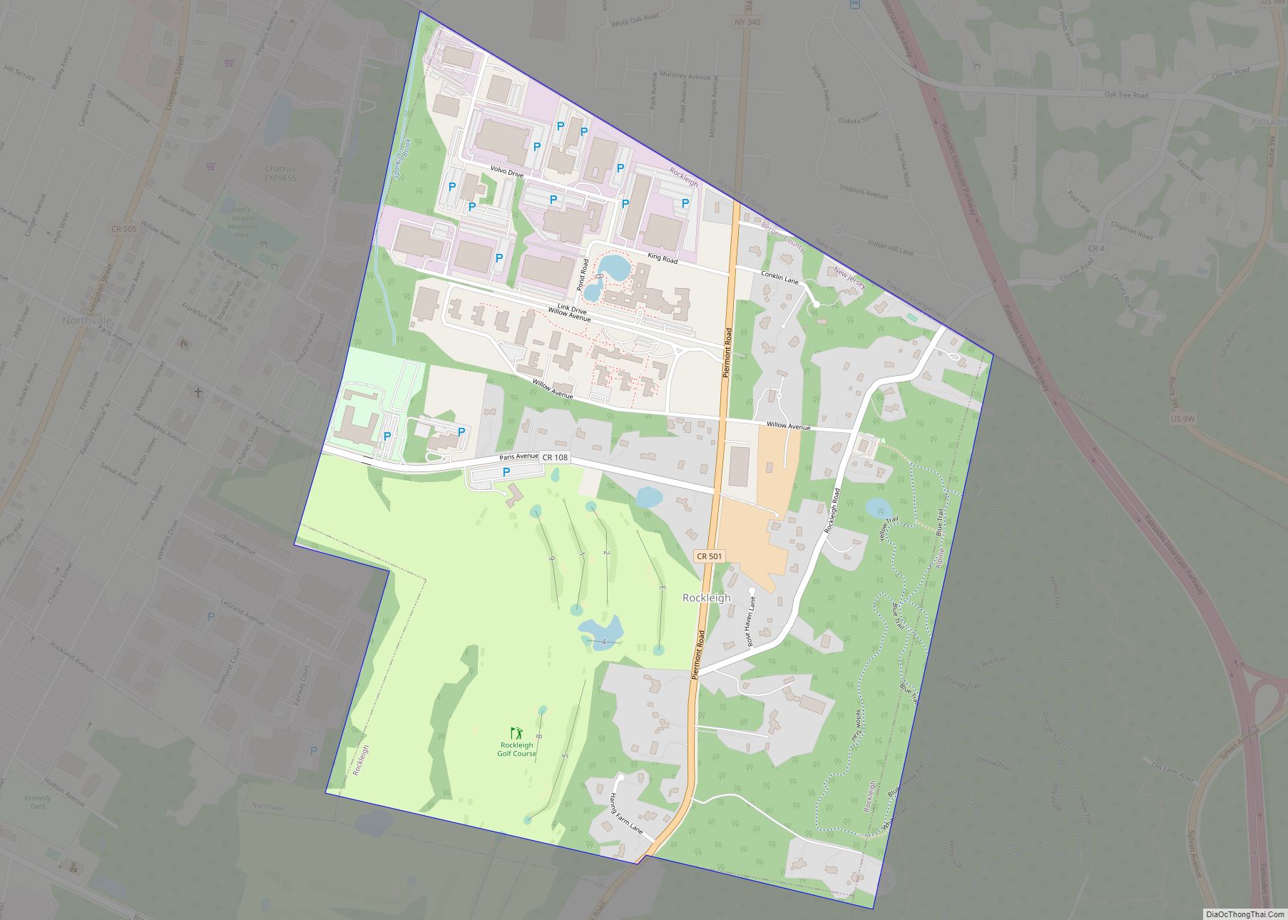
Rockleigh (pronounced ROCK-lee) is a borough in northeastern Bergen County, in the U.S. state of New Jersey. As of the 2020 United States census, the borough’s population was 407, a decrease of 124 (−23.4%) from the 2010 census count of 531, which in turn reflected an increase of 140 (+35.8%) from the 391 counted at ... Read more
Map of Rockleigh borough
Map of Rossmoor CDP, New Jersey
Rossmoor is an unincorporated community and census-designated place (CDP) located within Monroe Township in Middlesex County, New Jersey, United States. As of the 2010 United States Census, the CDP’s population was 2,666. Rossmoor is a gated age-restricted co-op, active adult community . Rossmoor covers 418 acres (1.69 km) just off Exit 8A of the New Jersey ... Read more
Map of Rossmoor CDP, New Jersey
Map of Ross Corner CDP
Ross Corner is an unincorporated community and census-designated place (CDP) located in Frankford Township, in Sussex County, New Jersey, United States. As of the 2010 United States Census, the CDP’s population was 13. Ross Corner CDP overview: Name: Ross Corner CDP LSAD Code: 57 LSAD Description: CDP (suffix) State: New Jersey County: Sussex County Elevation: ... Read more
Map of Ross Corner CDP
Map of Seabrook Farms CDP
Seabrook Farms is an unincorporated community and census-designated place (CDP) located within Seabrook, which is in turn located in Upper Deerfield Township, in Cumberland County, in the U.S. state of New Jersey. It is part of the Vineland–Bridgeton metropolitan statistical area for statistical purposes. At the 2010 census, Seabrook Farms’s population was 1,484. Seabrook Farms ... Read more
Map of Seabrook Farms CDP
Map of Sea Isle City
Sea Isle City is a city in Cape May County, in the U.S. state of New Jersey. The city, and all of Cape May County, is part of the South Jersey region of the state and of the Ocean City metropolitan statistical area, and is part of the Philadelphia–Wilmington–Camden, PA-NJ-DE–MD combined statistical area, also known ... Read more
Map of Sea Isle City
Map of Sea Girt borough
Sea Girt is a borough situated on the Jersey Shore, within Monmouth County, in the U.S. state of New Jersey. As of the 2020 United States census, the borough’s population was 1,866, an increase of 38 (+2.1%) from the 2010 census count of 1,828, which in turn had reflected a decline of 320 (−14.9%) from ... Read more
Map of Sea Girt borough
Map of Sea Bright borough
Sea Bright is a borough situated on the Jersey Shore, within Monmouth County, in the U.S. state of New Jersey. As of the 2020 United States census, the borough’s population was 1,449, an increase of 37 (+2.6%) from the 2010 census count of 1,412, which in turn had reflected a decline of 406 (−22.3%) from ... Read more
Map of Sea Bright borough
Map of Sayreville borough
Sayreville is a borough in Middlesex County, in the U.S. state of New Jersey. Sayreville is within the heart of the Raritan Valley region, located on the south banks of the Raritan River, and also located on the Raritan Bay. As of the 2020 United States census, the borough’s population was 45,345, an increase of ... Read more
Map of Sayreville borough
Map of Salem city, New Jersey
Salem is a city in Salem County, in the U.S. state of New Jersey. It is the county seat of Salem County, the state’s most rural county. The name Salem, for both the city and county, is derived from the Hebrew word shalom, meaning peace. As of the 2020 United States census, the city’s population ... Read more
Map of Salem city, New Jersey