Sayreville is a borough in Middlesex County, in the U.S. state of New Jersey. Sayreville is within the heart of the Raritan Valley region, located on the south banks of the Raritan River, and also located on the Raritan Bay. As of the 2020 United States census, the borough’s population was 45,345, an increase of 2,641 (+6.2%) from the 2010 census count of 42,704, which in turn reflected an increase of 2,327 (+5.8%) from the 40,377 counted in the 2000 census.
Sayreville was originally incorporated as a township on April 6, 1876, from portions of South Amboy Township. On April 2, 1919, the borough was reincorporated as the Borough of Sayreville and ratified by a referendum held on April 29, 1919.
| Name: | Sayreville borough |
|---|---|
| LSAD Code: | 21 |
| LSAD Description: | borough (suffix) |
| State: | New Jersey |
| County: | Middlesex County |
| Incorporated: | April 6, 1876 (as township) |
| Elevation: | 10 ft (3 m) |
| Total Area: | 18.66 sq mi (48.33 km²) |
| Land Area: | 15.83 sq mi (41.00 km²) |
| Water Area: | 2.83 sq mi (7.34 km²) 15.24% |
| Total Population: | 45,345 |
| Population Density: | 2,864.5/sq mi (1,106.0/km²) |
| Area code: | 908, 732 and 848 |
| FIPS code: | 3465790 |
| GNISfeature ID: | 0885386 |
| Website: | www.sayreville.com |
Online Interactive Map
Click on ![]() to view map in "full screen" mode.
to view map in "full screen" mode.
Sayreville location map. Where is Sayreville borough?


History
Native Americans were the first settlers of Sayreville. Tribes of the Navesink lived along the South River where Jernee Mill Road is located today. This was noted on a 1656 New Netherland map by Adriaen van der Donck, a Dutch surveyor and map maker. Attempting to buy land from the Native Americans, European settlers travelled up the Raritan River in 1663. During the 20th century, amateur archaeologists found thousands of Indian artifacts at the location shown on the map.
Predating the incorporation of Sayreville, the Morgan Inn (later known as the Old Spye Inn) was established in 1703 in what is now the Morgan section of Sayreville. Charles Morgan III and his descendants, including Major General James Morgan and Lieutenant Nicholas Morgan, played significant roles in the Revolutionary War. The Morgan family lived in the area for over 200 years and many family members, including Evertsons, are buried in the privately owned Morgan Cemetery, which overlooks Raritan Bay. The Morgans were said to be related to the famous pirate, Captain Henry Morgan, who is said to have visited the Inn on more than one occasion, although this would have been impossible, considering Morgan died in Jamaica in 1688 and the Old Spye Inn wasn’t built until 1703.
It was from an episode during the Revolutionary War that the Morgan Inn gained its new name, the Old Spye Inn. According to local legends, a local British loyalist, Abe Mussey, was captured by Continental Army troops in 1777 while signaling to British ships in Raritan Bay. He was tried as a spy at the Inn, convicted in a one-day trial, and sentenced to death by hanging. Mussey’s execution was carried out using a tree near the Inn’s entrance. Mussey was reported to be buried behind the Inn in an unmarked grave. The Inn was destroyed by fire in 1976, but its ruins remain on the National Register of Historic Places.
Originally known as Roundabout (for the river bends in the area) and then as Wood’s Landing, the community was renamed in the 1860s for James R. Sayre Jr. of Newark, who co-founded Sayre and Fisher Brick Company in the 1850s together with Peter Fisher. It was one of the many companies that took advantage of the extensive clay deposits that supported the brick industry from the early 19th century until 1970. From its inception, Sayre & Fisher quickly grew into one of the largest brick-making companies in the world. Production grew from 54 million bricks annually in 1878, to 178 million bricks a year in 1913, and had reached a total of 6.2 billion bricks in the 100 years through its centennial in 1950.
In 1898, DuPont began production of gunpowder at its plant on Deerfield Road, and later off Washington Road. The company later built additional facilities in Sayreville for the production of paint and photo products.
At one time the Raritan River Railroad passed through Sayreville and had several spurs to service Sayre & Fisher and other local industries. A train running on the line was featured in “The Juggernaut,” a 1914 episode of the silent movie serial The Perils of Pauline. The episode was staged on the line, including the construction of a bridge over Ducks Nest Pond in Sayreville. The fishing pond is located in the back of Bailey Park, near the DuPont and Hercules factories.
In 1918 during World War I, Sayreville was heavily damaged by TNT explosions at the Gillespie Shell Loading Plant. The disaster killed dozens and injured hundreds of local victims, damaged hundreds of buildings, required an emergency declaration of martial law, and scattered wide areas of ammunition remnants that continue to surface occasionally.
Sayreville’s clay deposits have earned scientific notice as one of the world’s major sources of museum-quality fossils found in amber (see New Jersey amber). This prehistoric tree resin managed to encase over a hundred species of insects and plants from approximately 90 million years ago, when Sayreville had a tropical climate. The fossils have been extensively researched and published by David Grimaldi, curator of invertebrate zoology at the American Museum of Natural History.
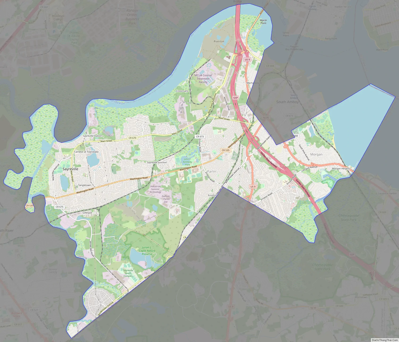
Sayreville Road Map
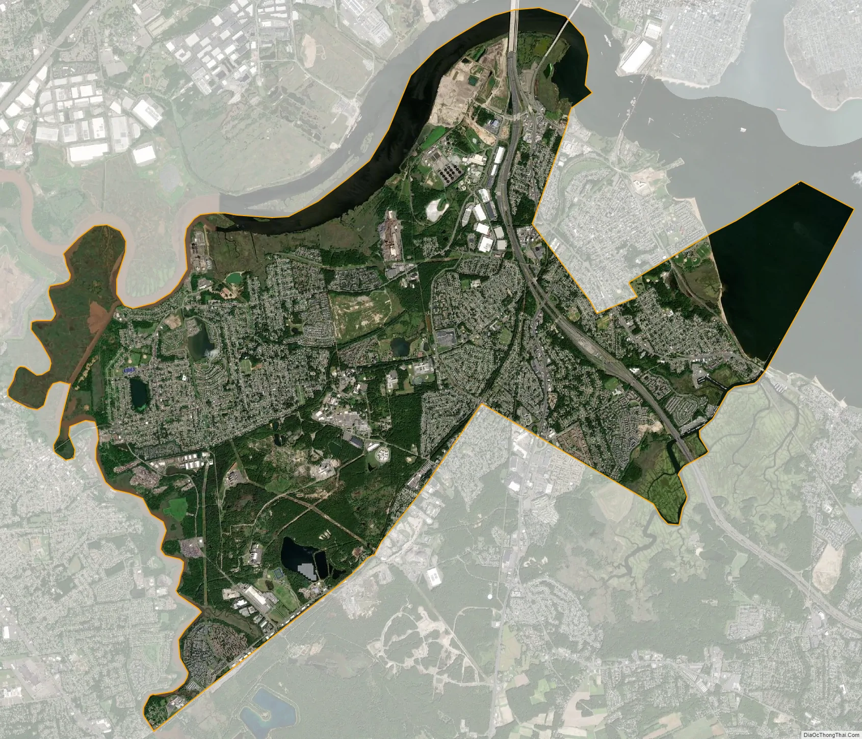
Sayreville city Satellite Map
Geography
According to the United States Census Bureau, the borough had a total area of 18.68 square miles (48.37 km), including 15.83 square miles (41.00 km) of land and 2.85 square miles (7.37 km) of water (15.24%).
The borough is located on the southern bank of the Raritan River across from Woodbridge Township and Perth Amboy, and is bordered on the southwest and south by Old Bridge Township. The borough also borders East Brunswick, Edison, South Amboy, and South River in Middlesex County, and Staten Island in New York City.
Low-lying areas near the Raritan River are subject to flooding associated with storm surges. The borough is approximately 24 miles (39 km) southwest of Lower Manhattan, 4 miles (6.4 km) southwest of Staten Island and 57 miles (92 km) northeast of Philadelphia. Area codes 908, 732 and 848 are used in Sayreville.
Sayreville uses four ZIP Codes; 08871 and 08872 are post offices located in the borough itself, while 08879 is the South Amboy ZIP Code serving the Morgan and Melrose sections of Sayreville, South Amboy, and the Laurence Harbor neighborhood of Old Bridge Township. ZIP Code 08859 is the Parlin post office, which serves adjoining portions of Sayreville and Old Bridge Township.
There are several distinct neighborhoods in Sayreville. Unincorporated communities, localities and place names within the borough include: Crossmans, Ernston, Gillespie, Laurel Park, MacArthur Manor, Melrose, Morgan, Morgan Heights, Phoenix, Runyon, Sayre Woods, Sayreville Junction, and Sayreville Station.
See also
Map of New Jersey State and its subdivision: Map of other states:- Alabama
- Alaska
- Arizona
- Arkansas
- California
- Colorado
- Connecticut
- Delaware
- District of Columbia
- Florida
- Georgia
- Hawaii
- Idaho
- Illinois
- Indiana
- Iowa
- Kansas
- Kentucky
- Louisiana
- Maine
- Maryland
- Massachusetts
- Michigan
- Minnesota
- Mississippi
- Missouri
- Montana
- Nebraska
- Nevada
- New Hampshire
- New Jersey
- New Mexico
- New York
- North Carolina
- North Dakota
- Ohio
- Oklahoma
- Oregon
- Pennsylvania
- Rhode Island
- South Carolina
- South Dakota
- Tennessee
- Texas
- Utah
- Vermont
- Virginia
- Washington
- West Virginia
- Wisconsin
- Wyoming


