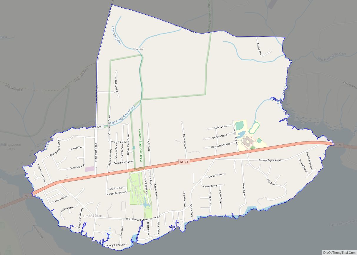
Map of Bunn town

Map of Bunn town

Bunn is a town in Franklin County, North Carolina, United States. The population was 327 at the 2020 census. Bunn town overview: Name: Bunn town LSAD Code: 43 LSAD Description: town (suffix) State: North Carolina County: Franklin County Incorporated: March 3, 1913 Elevation: 279 ft (85 m) Total Area: 0.54 sq mi (1.40 km²) Land Area: 0.54 sq mi (1.40 km²) Water Area: … Read more

Map of Buies Creek CDP

Map of Buies Creek CDP

Buies Creek (/ˈbuːiːz/ BOO-EEZ) is a census-designated place (CDP) located in the Neills Creek Township of Harnett County, North Carolina, United States. It is the home of Campbell University. The population was 3,253 at the 2020 census, up from 2,942 in 2010. Buies Creek is a part of the Dunn Micropolitan Area, which is also … Read more

Map of Camden CDP, North Carolina

Map of Camden CDP, North Carolina

Camden is an unincorporated town and Census-designated place in Camden County, North Carolina, United States. It is the county seat of Camden County, a consolidated city-county. As of the 2010 census, the Camden town had a population of 599. Camden is located on the eastern banks of the Pasquotank River, across from which lies Elizabeth … Read more

Map of Calypso town

Map of Calypso town

Calypso is a town in Duplin County, North Carolina, United States. The population was 538 at the 2010 census. Calypso town overview: Name: Calypso town LSAD Code: 43 LSAD Description: town (suffix) State: North Carolina County: Duplin County Elevation: 161 ft (49 m) Total Area: 1.00 sq mi (2.60 km²) Land Area: 1.00 sq mi (2.59 km²) Water Area: 0.00 sq mi (0.00 km²) Total Population: … Read more

Map of Calabash town

Map of Calabash town

Calabash is a small fishing town in Brunswick County, North Carolina, United States. The population was 1,786 at the 2010 census, up from 711 in 2000. It prides itself on being known as the “Seafood Capital of the World” because of the town’s seafood restaurants. Calabash is part of the Myrtle Beach Metropolitan Area. Calabash … Read more

Map of Cajah's Mountain town

Map of Cajah’s Mountain town

Cajah’s Mountain is a town in Caldwell County, North Carolina, United States. The population was 2,823 at the 2010 census. It is part of the Hickory–Lenoir–Morganton Metropolitan Statistical Area. Cajah’s Mountain town overview: Name: Cajah’s Mountain town LSAD Code: 43 LSAD Description: town (suffix) State: North Carolina County: Caldwell County Elevation: 1,312 ft (400 m) Total Area: … Read more

Map of Buxton CDP

Map of Buxton CDP, North Carolina

Buxton is an unincorporated community and census-designated place (CDP) on Hatteras Island (part of the Outer Banks) near Cape Hatteras. It is located in Dare County in the U.S. state of North Carolina. As of the 2010 census, it had a population of 1,273. Located at the widest part of Hatteras Island, it is the … Read more

Map of Butters CDP

Map of Butters CDP

Butters is a census-designated place (CDP) in Bladen County, North Carolina, United States. As of the 2010 census, the population was 294. Butters CDP overview: Name: Butters CDP LSAD Code: 57 LSAD Description: CDP (suffix) State: North Carolina County: Bladen County Elevation: 112 ft (34 m) Total Area: 1.49 sq mi (3.85 km²) Land Area: 1.48 sq mi (3.83 km²) Water Area: 0.01 sq mi … Read more

Map of Butner town

Map of Butner town

Butner is a town in Granville County, North Carolina, United States. The population was 8,397 as of the 2020 census. Butner was managed by the state of North Carolina from 1947 through 2007. Butner town overview: Name: Butner town LSAD Code: 43 LSAD Description: town (suffix) State: North Carolina County: Granville County Elevation: 371 ft (113 m) … Read more

Map of Burnsville town, North Carolina

Map of Burnsville town, North Carolina

Burnsville is a town that serves as the county seat of Yancey County, North Carolina, United States. The population was 1,612 at the 2020 census. Burnsville town overview: Name: Burnsville town LSAD Code: 43 LSAD Description: town (suffix) State: North Carolina County: Yancey County Elevation: 2,825 ft (861 m) Total Area: 1.60 sq mi (4.14 km²) Land Area: 1.60 sq mi (4.14 km²) … Read more

Map of Burlington city, North Carolina

Map of Burlington city, North Carolina

Burlington is a city in Alamance and Guilford counties in the U.S. state of North Carolina. It is the principal city of the Burlington, North Carolina Metropolitan Statistical Area, which encompasses all of Alamance County, in which most of the city is located, and is a part of the Greensboro-Winston-Salem-High Point Combined Statistical Area. The … Read more

Map of Burgaw town

Map of Burgaw town

Burgaw is a town in, and the county seat of, Pender County, North Carolina, United States. The population was 3,088 at the 2020 census. Burgaw is part of the Wilmington Metropolitan Statistical Area. Burgaw town overview: Name: Burgaw town LSAD Code: 43 LSAD Description: town (suffix) State: North Carolina County: Pender County Incorporated: 1879 Elevation: … Read more