Map of Newport city, Oregon

Map of Newport city, Oregon

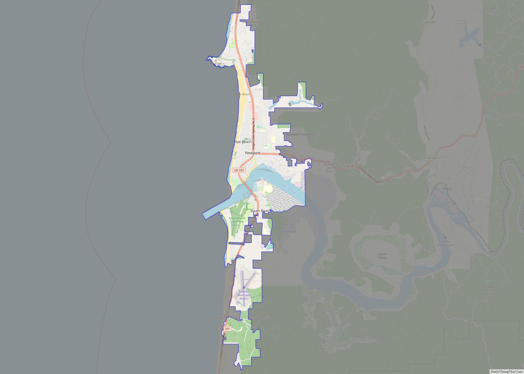
Newport is a city in Lincoln County, Oregon, United States. It was incorporated in 1882, though the name dates back to the establishment of a post office in 1868. Newport was named for Newport, Rhode Island. As of the 2010 census, the city had a total population of 9,989, an increase of nearly 5% over … Read more

Map of Newberg city

Map of Newberg city

Newberg is a city in Yamhill County, Oregon, United States. Located in the Portland metropolitan area, the city is home to George Fox University. As of the 2020 census, the city population was 25,138 making it the second most populous city in the county. Newberg city overview: Name: Newberg city LSAD Code: 25 LSAD Description: … Read more

Map of New Pine Creek CDP, Oregon

Map of New Pine Creek CDP, Oregon

New Pine Creek is a census-designated place and unincorporated community in Lake County, Oregon, United States. As of the 2010 census, it had a population of 120. it has a post office with a ZIP code 97635. New Pine Creek lies on U.S. Route 395 at the Oregon–California border, just north of New Pine Creek, … Read more

Map of New Hope CDP, Oregon

Map of New Hope CDP, Oregon

New Hope is an unincorporated community and census-designated place (CDP) in Josephine County, Oregon, United States. As of the 2010 census it had a population of 1,515. New Hope CDP overview: Name: New Hope CDP LSAD Code: 57 LSAD Description: CDP (suffix) State: Oregon County: Josephine County Elevation: 1,040 ft (320 m) Total Area: 3.83 sq mi (9.91 km²) Land … Read more

Map of Oakridge city

Map of Oakridge city

Oakridge is a city in Lane County, Oregon, United States. The population was 3,205 as of the 2010 census. It is located east of Westfir on Oregon Route 58, about 40 miles (64 km) east of Eugene and 150 miles (240 km) southeast of Portland. Surrounded by the Willamette National Forest and the Cascade Range, Oakridge is … Read more

Map of Oakland city, Oregon

Map of Oakland city, Oregon

Oakland is a city in Douglas County, Oregon, United States, located 2 miles (3 km) from Interstate 5. The population was 927 at the 2010 census. Oakland city overview: Name: Oakland city LSAD Code: 25 LSAD Description: city (suffix) State: Oregon County: Douglas County Incorporated: 1878 Elevation: 456 ft (139 m) Total Area: 0.73 sq mi (1.89 km²) Land Area: 0.73 sq mi … Read more

Map of Oak Hills CDP, Oregon

Map of Oak Hills CDP, Oregon

Oak Hills is a census-designated place (CDP) and neighborhood in Washington County, Oregon, United States. The CDP population was 9,050 at the 2000 census. It is on unincorporated land north of Beaverton, west of Cedar Mill, and south/southeast of Bethany. The CDP is roughly bounded by the Sunset Highway on the south, West Union Road … Read more

Map of Paisley city, Oregon

Map of Paisley city, Oregon

Paisley is a city in Lake County, Oregon, United States. It is along Oregon Route 31 between Summer Lake and Lake Abert. The population was 250 at the 2020 census. Paisley city overview: Name: Paisley city LSAD Code: 25 LSAD Description: city (suffix) State: Oregon County: Lake County Incorporated: 1911 Elevation: 4,374 ft (1,333 m) Total Area: … Read more

Map of Pacific City CDP

Map of Pacific City CDP

Pacific City is a census-designated place (CDP) and unincorporated community in Tillamook County, Oregon, United States. The population was 1,076 at the 2019 census. Pacific City’s main attraction is the Cape Kiwanda State Natural Area. Pacific City CDP overview: Name: Pacific City CDP LSAD Code: 57 LSAD Description: CDP (suffix) State: Oregon County: Tillamook County … Read more

Map of Oregon City city

Map of Oregon City

Oregon City is the county seat of Clackamas County, Oregon, United States, located on the Willamette River near the southern limits of the Portland metropolitan area. As of the 2020 census, the city population was 37,572. Established in 1829 by the Hudson’s Bay Company, in 1844 it became the first U.S. city west of the … Read more

Map of Ontario city, Oregon

Map of Ontario city, Oregon

Ontario is the largest city in Malheur County, Oregon, United States. It lies along the Snake River at the Idaho border. The population was 11,366 at the 2010 census. The city is the largest community in the region of far eastern Oregon, also known as the Western Treasure Valley. Ontario is the principal city of … Read more

Map of Odell CDP, Oregon

Map of Odell CDP, Oregon

Odell is an unincorporated community and census-designated place (CDP) in Hood River County, Oregon, United States. Odell was named for an early pioneer, William Odell, a native of Tennessee by way of California, who settled in the area in 1861. The population was 2,255 as of the 2010 census. Odell CDP overview: Name: Odell CDP … Read more