Map of Indian River CDP
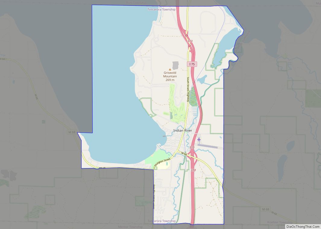
Indian River CDP overview: Name: Indian River CDP LSAD Code: 57 LSAD Description: CDP (suffix) State: Michigan County: Cheboygan County Elevation: 614 ft (187 m) Total Area: 20.29 sq mi (52.54 km²) Land Area: 12.93 sq mi (33.48 km²) Water Area: 7.36 sq mi (19.06 km²) Total Population: 1,950 Population Density: 150.85/sq mi (58.24/km²) Area code: 231 FIPS code: 2640480 GNISfeature ID: 0629015 Online Interactive Map Indian ... Read more
Map of Indian River CDP
Map of Imlay City
Imlay City is a city in Lapeer County in the U.S. state of Michigan. The population was 3,869 at the 2000 census and 3,585 at the 2020 census. Imlay City city overview: Name: Imlay City city LSAD Code: 25 LSAD Description: city (suffix) State: Michigan County: Lapeer County Elevation: 827 ft (252 m) Total Area: 2.45 sq mi (6.35 km²) ... Read more
Map of Imlay City
Map of Huntington Woods city
Huntington Woods is a city in Oakland County, Michigan in the U.S. state of Michigan. It is a northern suburb of Metro Detroit. The population was 6,238 at the 2010 census. Huntington Woods is situated along the Woodward Corridor (M-1) and is bounded by Ten and Eleven Mile Roads to the north and south and ... Read more
Map of Huntington Woods city
Map of Hudsonville city
Hudsonville is a city in Ottawa County in the U.S. state of Michigan, and is part of the Grand Rapids metropolitan area. The population was 7,116 at the 2010 census. Hudsonville is nicknamed “Michigan’s Salad Bowl.” Hudsonville city overview: Name: Hudsonville city LSAD Code: 25 LSAD Description: city (suffix) State: Michigan County: Ottawa County Elevation: ... Read more
Map of Hudsonville city
Map of Ironton CDP, Michigan
Ironton is an unincorporated community and census-designated place (CDP) in Charlevoix County in the U.S. state of Michigan. The population of the CDP was 148 at the 2020 census. It is located within Eveline Township on a narrow portion of Lake Charlevoix that is traversed by the Ironton Ferry. Ironton CDP overview: Name: Ironton CDP ... Read more
Map of Ironton CDP, Michigan
Map of Iron River city, Michigan
Iron River is a city in Iron County in the U.S. state of Michigan. As of the 2010 census, the city population was 3,029. The city is situated at the southeast corner of Iron River Township, but is administratively autonomous. Iron River is the birthplace and home of four-time US Olympian and 2022 gold medalist ... Read more
Map of Iron River city, Michigan
Map of Iron Mountain city
Iron Mountain is a city and the county seat of Dickinson County, Michigan. The population was 7,518 at the 2020 census, down from 7,624 at the 2010 census. in the state’s Upper Peninsula. Iron Mountain was named for the valuable iron ore found in the vicinity. Iron Mountain is the principal city of the Iron ... Read more
Map of Iron Mountain city
Map of Ionia city, Michigan
Ionia (/aɪˈoʊnjə/ eye-OH-nyə) is the largest city in, and the county seat of, Ionia County, Michigan, United States. The population was 13,378 at the 2020 census. Every July it hosts what is said to be the world’s largest free-admission fair. The city is mostly within Ionia Township, with small portion extending into Easton Township and ... Read more
Map of Ionia city, Michigan
Map of Interlochen CDP
Interlochen (/ˈɪntərˈlɒkɪn/ IN-ter-lock-in) is an unincorporated community and census-designated place (CDP) in Grand Traverse County in the U.S. state of Michigan. At the 2020 census, the population was 694, up from 583 at the 2010 census. The community is located within Green Lake Township. The community is home to the Interlochen Center for the Arts ... Read more
Map of Interlochen CDP
Map of Ironwood city
Ironwood is a city in Gogebic County in the Upper Peninsula of the U.S. state of Michigan, about 18 miles (29 km) south of Lake Superior. The city is on US Highway 2 across the Montreal River from Hurley, Wisconsin. It is the westernmost city in Michigan, situated on the same line of longitude (90.2 degrees ... Read more
Map of Ironwood city
Map of Jasper CDP, Michigan
Jasper is an unincorporated community and census-designated place (CDP) in Lenawee County in the U.S. state of Michigan. The CDP had a population of 412 at the 2010 census. Jasper is within Fairfield Township and has its own post office with the 49248 ZIP Code. Jasper CDP overview: Name: Jasper CDP LSAD Code: 57 LSAD ... Read more
Map of Jasper CDP, Michigan
Map of Jackson city, Michigan
Jackson is the only city and county seat of Jackson County in the U.S. state of Michigan. As of the 2020 census, the city population was 31,309. Located along Interstate 94 and U.S. Route 127, it is approximately 40 miles (64 km) west of Ann Arbor and 35 miles (56 km) south of Lansing. Jackson is the ... Read more
Map of Jackson city, Michigan