Map of Waco city, Texas

Map of Waco city, Texas

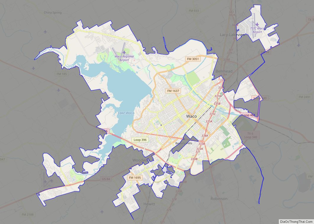
Waco (/ˈweɪkoʊ/ WAY-koh) is the county seat of McLennan County, Texas, United States. It is situated along the Brazos River and I-35, halfway between Dallas and Austin. The city had a 2020 population of 138,486, making it the 22nd-most populous city in the state. The 2021 U.S. Census population estimate for the city was 139,594. … Read more

Map of Gainesville city, Florida

Map of Gainesville city, Florida

Gainesville is the county seat of Alachua County, Florida, and the largest city in North Central Florida, with a population of 141,085 in 2020. It is the principal city of the Gainesville metropolitan area, which had a population of 339,247 in 2020. Gainesville is home to the University of Florida, the fourth-largest public university campus … Read more

Map of Warren city, Michigan

Map of Warren city, Michigan

Warren is a city in Macomb County in the U.S. state of Michigan. The 2020 Census places the city’s population at 139,387, making Warren the largest city in Macomb County, the third largest city in Michigan, and one of Metro Detroit’s core cities. The city is home to a wide variety of businesses, including General … Read more

Map of Dayton city, Ohio

Map of Dayton city, Ohio

Dayton (/ˈdeɪʔən/ (listen)) is the sixth-largest city in the U.S. state of Ohio and the county seat of Montgomery County. A small part of the city extends into Greene County. The 2020 U.S. census estimate put the city population at 137,644, while Greater Dayton was estimated to be at 814,049 residents. The Combined Statistical Area … Read more

Map of West Valley City city

Map of West Valley City

West Valley City is a city in Salt Lake County and a suburb of Salt Lake City in the U.S. state of Utah. The population was 140,230 at the 2020 census, making it the second-largest city in Utah. The city incorporated in 1980 from a large, quickly growing unincorporated area, combining the four communities of … Read more

Map of Pasadena city

Map of Pasadena city, California

Pasadena (/ˌpæsəˈdiːnə/ PAS-ə-DEE-nə) is a city in Los Angeles County, California, United States, 11 miles (18 km) northeast of downtown Los Angeles. It is the most populous city and the primary cultural center of the San Gabriel Valley. Old Pasadena is the city’s original commercial district. Its population was 138,699 at the 2020 census, making it … Read more

Map of Victorville city

Map of Victorville city

Victorville is a city in Victor Valley in San Bernardino County, California. Its population as of the 2020 census was 134,810. Victorville is the principal city of a Victor Valley–based urban area defined by the United States Census Bureau: the Victorville–Hesperia–Apple Valley urban area had a population of 355,816 as of the 2020 census, making … Read more

Map of Stamford city

Map of Stamford city, Connecticut

Stamford (/ˈstæmfərd/) is a city in Fairfield County, Connecticut, 34 miles (55 kilometers) outside of New York City. It is the largest city in the Western Connecticut Planning Region, and Connecticut’s second-most populous city, behind Bridgeport. With a population of 135,470, Stamford passed Hartford and New Haven in population as of the 2020 census. It … Read more