Map of Rochester city, Indiana
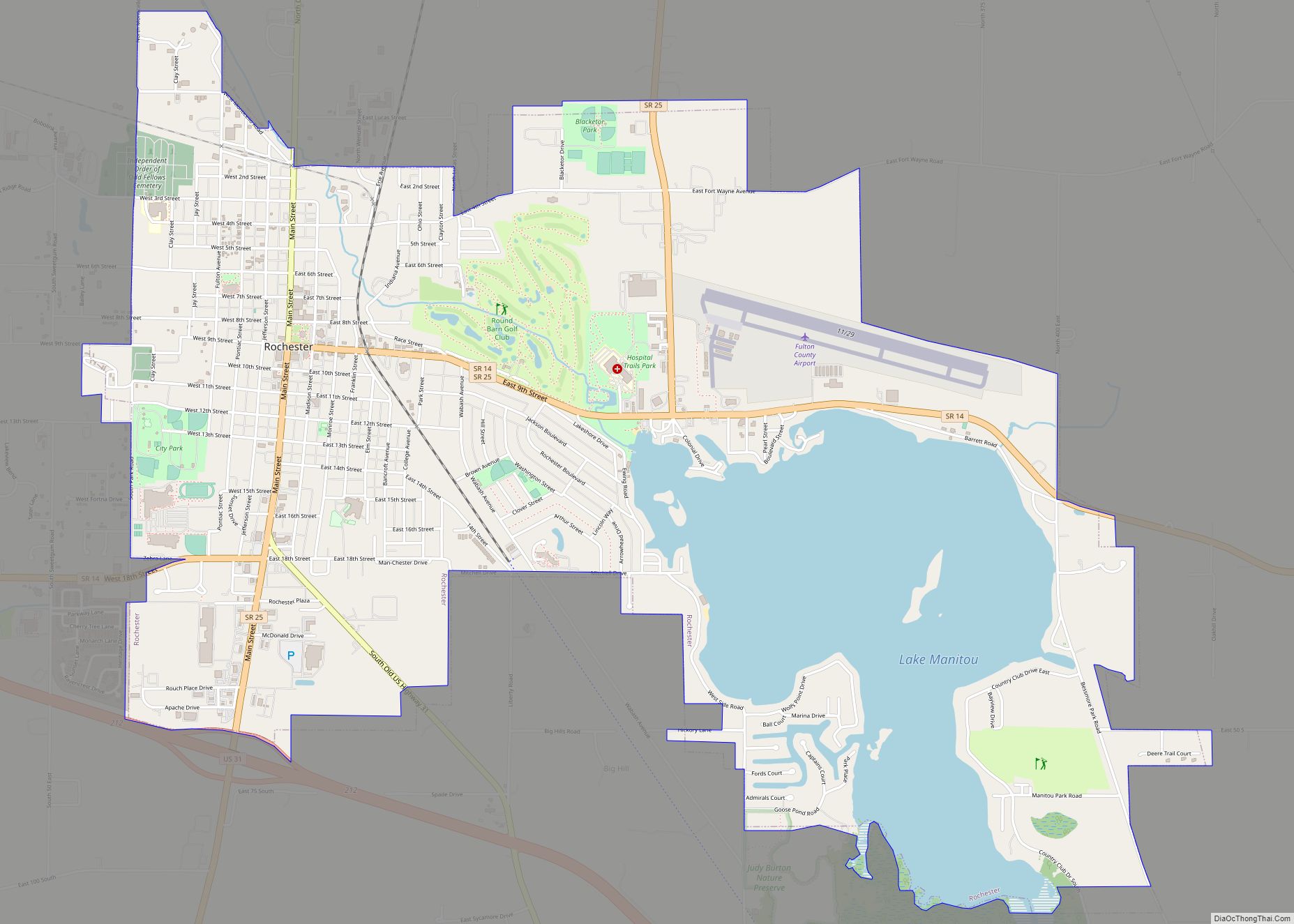
Rochester is a city in, and the county seat of, Fulton County, Indiana, United States. The population was 6,218 at the 2010 census. Rochester city overview: Name: Rochester city LSAD Code: 25 LSAD Description: city (suffix) State: Indiana County: Fulton County Elevation: 781 ft (238 m) Total Area: 5.68 sq mi (14.71 km²) Land Area: 4.57 sq mi (11.84 km²) Water Area: 1.11 sq mi ... Read more
Map of Rochester city, Indiana
Map of Roanoke town, Indiana
Roanoke is a town in Jackson Township, Huntington County, Indiana, United States. The population was 1,762 at the 2020 census. Roanoke is governed by a town council. Town offices include the clerk treasurer, utilities department, police department, and volunteer fire department. The town has a public elementary school. WOWO and WRNP have transmitter towers in ... Read more
Map of Roanoke town, Indiana
Map of Rolling Prairie CDP
Rolling Prairie is an unincorporated community and census-designated place (CDP) in Kankakee Township, LaPorte County, Indiana, United States. As of the 2010 census, it had a population of 582. Rolling Prairie CDP overview: Name: Rolling Prairie CDP LSAD Code: 57 LSAD Description: CDP (suffix) State: Indiana County: LaPorte County Elevation: 830 ft (250 m) Total Area: 1.07 sq mi ... Read more
Map of Rolling Prairie CDP
Map of Rocky Ripple town
Rocky Ripple is a town in Marion County, Indiana, United States. The population was 655 at the 2020 census. It was founded in 1928, and the town was incorporated as an “included town” as part of Unigov in 1970. It is part of Indianapolis, but retains a separate functioning town government under IC 36-3-1-11. Although ... Read more
Map of Rocky Ripple town
Map of Rockville town, Indiana
Rockville is a town in Adams Township, Parke County, in the U.S. state of Indiana. The population was 2,607 at the 2010 census. The town is the county seat of Parke County. It is known as “The Covered Bridge Capital of the World”. Rockville town overview: Name: Rockville town LSAD Code: 43 LSAD Description: town ... Read more
Map of Rockville town, Indiana
Map of Roseland town, Indiana
Roseland is a town in Clay Township, St. Joseph County, in the U.S. state of Indiana. The population was 630 at the 2010 Census. It is part of the South Bend–Mishawaka, IN-MI, Metropolitan Statistical Area. Roseland is known as “The Gateway Town”, on account of its location at the Notre Dame/South Bend exit of the ... Read more
Map of Roseland town, Indiana
Map of Rosedale town, Indiana
Rosedale is a town in Florida Township, Parke County, in the U.S. state of Indiana. The population was 725 at the 2010 census. Rosedale town overview: Name: Rosedale town LSAD Code: 43 LSAD Description: town (suffix) State: Indiana County: Parke County Elevation: 535 ft (163 m) Total Area: 0.40 sq mi (1.02 km²) Land Area: 0.40 sq mi (1.02 km²) Water Area: 0.00 sq mi ... Read more
Map of Rosedale town, Indiana
Map of Rome City town
Rome City is a town in Orange Township, Noble County, in the U.S. state of Indiana. The population was 1,361 at the 2010 census. Rome City town overview: Name: Rome City town LSAD Code: 43 LSAD Description: town (suffix) State: Indiana County: Noble County Elevation: 935 ft (285 m) Total Area: 2.47 sq mi (6.40 km²) Land Area: 1.47 sq mi (3.81 km²) ... Read more
Map of Rome City town
Map of Royal Center town
Royal Center is a town in Boone Township, Cass County, Indiana, United States. The population was 861 at the 2010 census. Royal Center town overview: Name: Royal Center town LSAD Code: 43 LSAD Description: town (suffix) State: Indiana County: Cass County Elevation: 735 ft (224 m) Total Area: 0.57 sq mi (1.48 km²) Land Area: 0.57 sq mi (1.48 km²) Water Area: 0.00 sq mi ... Read more
Map of Royal Center town
Map of Rossville town, Indiana
Rossville is a town in Ross Township, Clinton County, Indiana, United States. The population was 1,653 at the 2010 census. Rossville town overview: Name: Rossville town LSAD Code: 43 LSAD Description: town (suffix) State: Indiana County: Clinton County Founded: 1832 Incorporated: 1870 Elevation: 725 ft (221 m) Total Area: 0.46 sq mi (1.19 km²) Land Area: 0.46 sq mi (1.19 km²) Water Area: ... Read more
Map of Rossville town, Indiana
Map of Roselawn CDP
Roselawn is a census-designated place (CDP) in Newton and Jasper counties in the U.S. state of Indiana. The population was 4,131 at the 2010 census. Roselawn is known within northwestern Indiana for the two nudist resorts which operate in this town: the Ponderosa Sun Club and Sun Aura. Sun Aura resort was previously known as ... Read more
Map of Roselawn CDP
Map of Rushville city, Indiana
Rushville is a city in Rushville Township, Rush County, in the U.S. state of Indiana. The population was 6,341 at the 2010 census. The city is the county seat of Rush County. It, like the county, was named in honor of Dr. Benjamin Rush, who signed the Declaration of Independence. Rushville city overview: Name: Rushville ... Read more
Map of Rushville city, Indiana