Map of Estill Springs town

Map of Estill Springs town

Estill Springs is a town in Franklin County, Tennessee, United States. The population was 2,267 at the 2020 census. It is usually referred to simply as “Estill” by its inhabitants. Estill Springs is part of the Tullahoma, Tennessee, Micropolitan Statistical Area and is located in Middle Tennessee. Estill Springs town overview: Name: Estill Springs town … Read more

Map of Erwin town, Tennessee

Map of Erwin town, Tennessee

Erwin is a town in and the county seat of Unicoi County, Tennessee, United States. The population was 6,097 at the 2010 census. It is part of the Johnson City Metropolitan Statistical Area, which is a component of the Johnson City–Kingsport–Bristol, TN-VA Combined Statistical Area – commonly known as the “Tri-Cities” region. Erwin town overview: … Read more

Map of Erin city, Tennessee

Map of Erin city, Tennessee

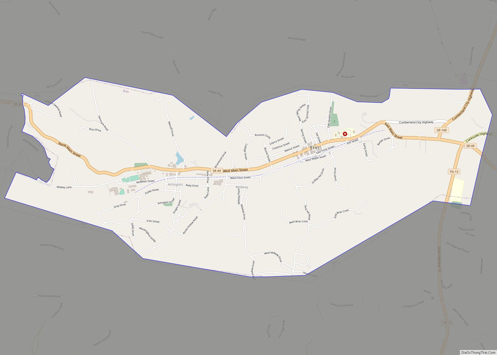
Erin is a city in and the county seat of Houston County, Tennessee. The population was 1,224 at the time of the 2020 census and 1,324 at the time of the 2010 census. Erin city overview: Name: Erin city LSAD Code: 25 LSAD Description: city (suffix) State: Tennessee County: Houston County Elevation: 480 ft (146 m) Total … Read more

Map of Enville town

Map of Enville town

Enville is a town in Chester and McNairy counties, Tennessee. The population was 230 at the 2000 census and 189 in 2010. Enville town overview: Name: Enville town LSAD Code: 43 LSAD Description: town (suffix) State: Tennessee County: Chester County, McNairy County Elevation: 420 ft (128 m) Total Area: 1.45 sq mi (3.74 km²) Land Area: 1.45 sq mi (3.74 km²) Water Area: … Read more

Map of Englewood town, Tennessee

Map of Englewood town, Tennessee

Englewood is a town in McMinn County, Tennessee, United States. The population was 1,550 in 2020. Englewood town overview: Name: Englewood town LSAD Code: 43 LSAD Description: town (suffix) State: Tennessee County: McMinn County Incorporated: 1919 Elevation: 860 ft (262 m) Total Area: 1.91 sq mi (4.95 km²) Land Area: 1.91 sq mi (4.95 km²) Water Area: 0.00 sq mi (0.00 km²) Total Population: 1,550 Population … Read more

Map of Elkton city, Tennessee

Map of Elkton city, Tennessee

Elkton is a city in Giles County, Tennessee, United States. The population was 578 at the 2010 census. Elkton city overview: Name: Elkton city LSAD Code: 25 LSAD Description: city (suffix) State: Tennessee County: Giles County Elevation: 656 ft (200 m) Total Area: 1.99 sq mi (5.16 km²) Land Area: 1.99 sq mi (5.16 km²) Water Area: 0.00 sq mi (0.00 km²) Total Population: 545 Population … Read more

Map of Elizabethton city

Map of Elizabethton city

Elizabethton is a city in, and the county seat of Carter County, Tennessee, United States. Elizabethton is the historical site of the first independent American government (known as the Watauga Association, created in 1772) located west of both the Eastern Continental Divide and the original Thirteen Colonies. The city is also the historical site of … Read more

Map of Elgin CDP, Tennessee

Map of Elgin CDP, Tennessee

Elgin is a census-designated place and unincorporated community in Scott County, Tennessee, United States. Its population was 282 as of the 2010 census. Elgin has a post office with ZIP code 37732, which opened on January 14, 1891. Elgin CDP overview: Name: Elgin CDP LSAD Code: 57 LSAD Description: CDP (suffix) State: Tennessee County: Scott … Read more

Map of Fairview city, Tennessee

Map of Fairview city, Tennessee

Fairview is a city located in Williamson County, Tennessee. It is part of the Nashville metropolitan area. The population was 9,357 at the 2020 census, . In the communities just outside Fairview, there are an additional 4,100 people, for a total of over 13,457 people living within the Fairview area. Fairview city overview: Name: Fairview … Read more

Map of Fairmount CDP, Tennessee

Map of Fairmount CDP, Tennessee

Fairmount is a census-designated place (CDP) in Hamilton County, Tennessee, United States. The population was 2,193 at the 2020 census, down from 2,825 at the 2010 census. It is part of the Chattanooga, TN–GA Metropolitan Statistical Area. Fairmont is located within the town of Signal Mountain‘s zip code, 37377, along with the town of Walden … Read more

Map of Fairgarden CDP

Map of Fairgarden CDP

Fairgarden is a census-designated place in Sevier County, Tennessee, United States. Its population was 529 as of the 2010 census. Fairgarden CDP overview: Name: Fairgarden CDP LSAD Code: 57 LSAD Description: CDP (suffix) State: Tennessee County: Sevier County Elevation: 1,640 ft (500 m) Total Area: 1.73 sq mi (4.48 km²) Land Area: 1.73 sq mi (4.48 km²) Water Area: 0.00 sq mi (0.00 km²) Total Population: … Read more

Map of Fairfield CDP, Tennessee

Map of Fairfield CDP, Tennessee

Fairfield is a census-designated place and unincorporated community in Sumner County, Tennessee, United States. Its population was 131 as of the 2010 census. Fairfield CDP overview: Name: Fairfield CDP LSAD Code: 57 LSAD Description: CDP (suffix) State: Tennessee County: Sumner County Elevation: 810 ft (250 m) Total Area: 0.991 sq mi (2.57 km²) Land Area: 0.991 sq mi (2.57 km²) Water Area: 0 sq mi … Read more