Map of Cornersville town

Map of Cornersville town

Cornersville is a town in Marshall County, Tennessee, United States. The population was 1,228 at the 2020 census. Cornersville town overview: Name: Cornersville town LSAD Code: 43 LSAD Description: town (suffix) State: Tennessee County: Marshall County Elevation: 883 ft (269 m) Total Area: 5.55 sq mi (14.38 km²) Land Area: 5.55 sq mi (14.38 km²) Water Area: 0.00 sq mi (0.00 km²) Total Population: 1,228 Population … Read more

Map of Cumberland City town

Map of Cumberland City town

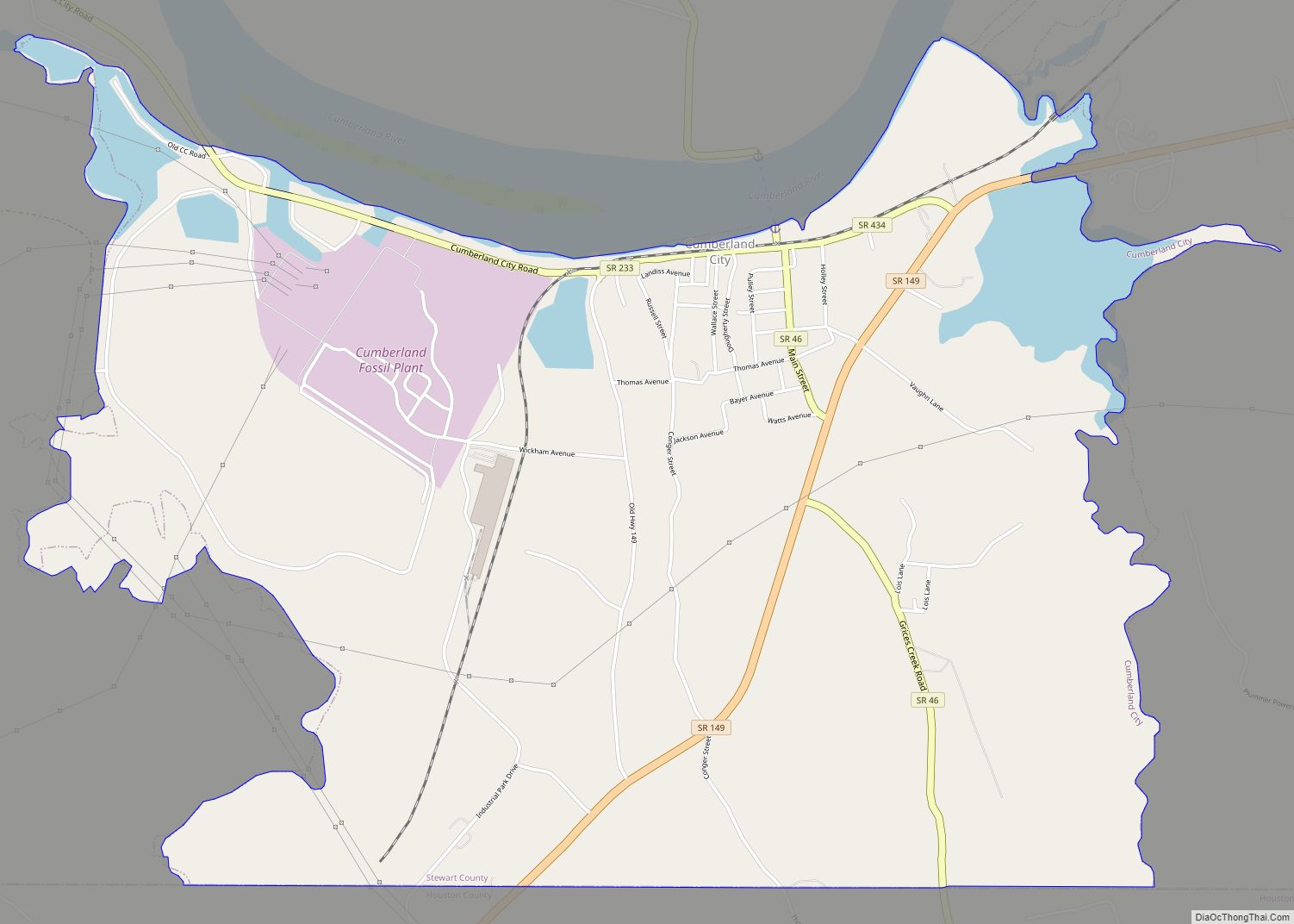
Cumberland City is a town in Stewart County, Tennessee. The population was 311 at the 2010 census. It is part of the Clarksville, TN — Kentucky Metropolitan Statistical Area. Cumberland City is the site of a TVA Cumberland Fossil Plant along the Cumberland River that provides 2.6 gigawatts of electric power to much of the … Read more

Map of Dover city, Tennessee

Map of Dover city, Tennessee

Dover is a city in and the county seat of Stewart County, Tennessee, 67 miles (108 km) west-northwest of Nashville on the Cumberland River. Fort Donelson National Cemetery is in Dover. The population was 1,442 at the 2000 census and the 2010 census showed a population of 1,417. Dover is part of the Clarksville, TN–Kentucky Metropolitan … Read more

Map of Dodson Branch CDP

Map of Dodson Branch CDP

Dodson Branch is a census-designated place and unincorporated community in Jackson County, Tennessee, United States. Its population was 1,044 as of the 2020 census. Dodson Branch CDP overview: Name: Dodson Branch CDP LSAD Code: 57 LSAD Description: CDP (suffix) State: Tennessee County: Jackson County Elevation: 981 ft (299 m) Total Area: 11.11 sq mi (28.77 km²) Land Area: 11.11 sq mi (28.77 km²) … Read more

Map of Dickson city, Tennessee

Map of Dickson city, Tennessee

Dickson is a city in the U.S. state of Tennessee. Located in Dickson County. It is part of the Nashville metropolitan area. As of the 2020 census, Dickson’s population was 16,058. Dickson city overview: Name: Dickson city LSAD Code: 25 LSAD Description: city (suffix) State: Tennessee County: Dickson County Elevation: 804 ft (245 m) Total Area: 20.41 sq mi … Read more

Map of Decherd city

Map of Decherd city

Decherd is a city in Franklin County, Tennessee, United States. The population was 2,379 at the 2020 census and 2,361 at the 2010 census. Decherd city overview: Name: Decherd city LSAD Code: 25 LSAD Description: city (suffix) State: Tennessee County: Franklin County Elevation: 961 ft (293 m) Total Area: 4.80 sq mi (12.44 km²) Land Area: 4.79 sq mi (12.42 km²) Water Area: … Read more

Map of Decaturville town

Map of Decaturville town

Decaturville is a town in and the county seat of Decatur County, Tennessee, United States. The population was 867 at the 2010 census. It is named for American Revolutionary War Commodore Stephen Decatur, Jr. Decaturville town overview: Name: Decaturville town LSAD Code: 43 LSAD Description: town (suffix) State: Tennessee County: Decatur County Elevation: 518 ft (158 m) … Read more

Map of Decatur town, Tennessee

Map of Decatur town, Tennessee

Decatur (/dɪˈkeɪtər/ dih-KAY-tər) is a town in Meigs County, Tennessee, United States. The population was 1,563 at the 2020 census. It is the county seat of Meigs County. Decatur town overview: Name: Decatur town LSAD Code: 43 LSAD Description: town (suffix) State: Tennessee County: Meigs County Founded: 1836 Incorporated: 1838 Elevation: 778 ft (237 m) Total Area: … Read more

Map of Dayton city, Tennessee

Map of Dayton city, Tennessee

Dayton is a city and county seat in Rhea County, Tennessee, United States. As of the 2020 census, the city population was 7,065. The Dayton Urban Cluster, which includes developed areas adjacent to the city and extends south to Graysville. Dayton was the site of the Scopes Trial in 1925 dealing with the creation–evolution controversy. … Read more

Map of Darden CDP

Map of Darden CDP

Darden is an unincorporated community and census-designated place (CDP) in Henderson County, Tennessee, United States. As of the 2010 census, its population was 399. The ZIP code is 38328. Darden CDP overview: Name: Darden CDP LSAD Code: 57 LSAD Description: CDP (suffix) State: Tennessee County: Henderson County Elevation: 463 ft (141 m) Total Area: 8.39 sq mi (21.73 km²) Land … Read more

Map of Dandridge town

Map of Dandridge town

Dandridge is a town in and the county seat of Jefferson County, Tennessee, United States. It had a population of 3,344 at the 2020 census. The town is part of the Morristown, Tennessee Metropolitan Statistical Area, which consists of Jefferson, Hamblen, and Grainger counties. It is considered a suburb of Knoxville based on its proximity … Read more

Map of Cumberland Gap town

Map of Cumberland Gap town

Cumberland Gap is a town in Claiborne County, Tennessee, United States. Its population was 494 at the 2010 census, and estimated to be 490 in 2019. The town is located below the Cumberland Gap, a historic mountain pass for which is the town’s namesake, and inside of the boundaries of Cumberland Gap National Historical Park. … Read more