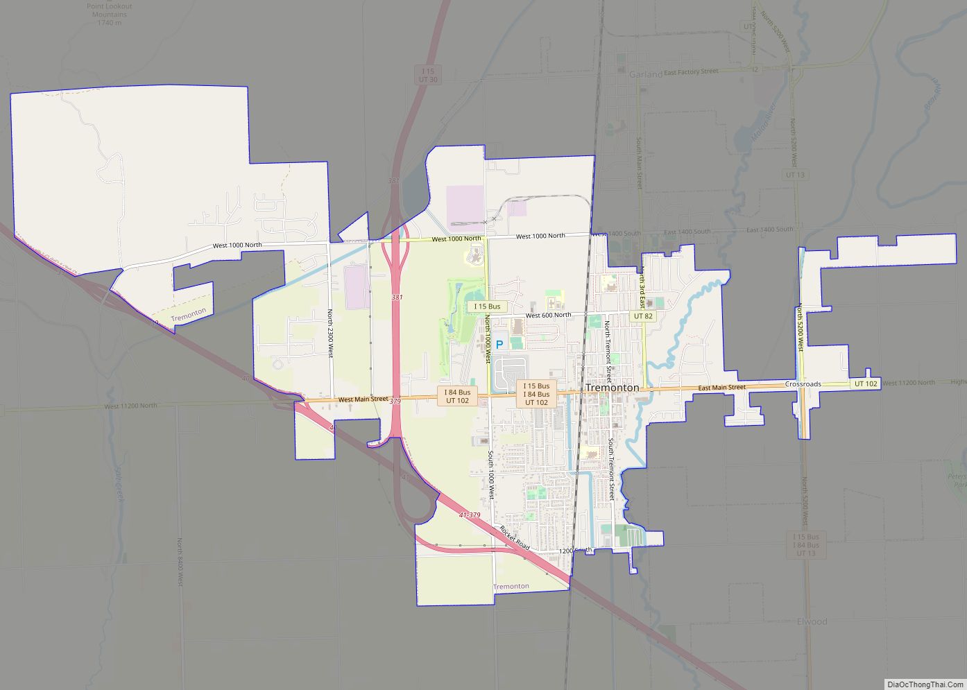
Map of Randolph town, Utah

Map of Randolph town, Utah

Randolph is a town in Rich County, Utah, United States. As of the 2010 census, the town population was 464. It is the county seat of Rich County. Randolph had the highest percentage of people of any city in the country vote for George W. Bush in the 2004 election, at 95.6% Randolph’s municipal classification … Read more

Map of Randlett CDP, Utah

Map of Randlett CDP, Utah

Randlett is a census-designated place (CDP) in west-central Uintah County, Utah, United States. In the 2000 census its population was 224, a 21% decrease from the 1990 figure of 283. Randlett began as the site of a school for Ute children in 1892. Randlett CDP overview: Name: Randlett CDP LSAD Code: 57 LSAD Description: CDP … Read more

Map of Providence city, Utah

Map of Providence city, Utah

Providence is a city in Cache County, Utah, United States. The population was 7,075 at the 2010 census. It is included in the Logan, Utah-Idaho Metropolitan Statistical Area. Providence city overview: Name: Providence city LSAD Code: 25 LSAD Description: city (suffix) State: Utah County: Cache County Founded: April 20, 1859 Elevation: 4,596 ft (1,401 m) Total Area: … Read more

Map of Price city

Map of Price city

Price is a city in the U.S. state of Utah and the county seat of Carbon County. The city is home to Utah State University Eastern, as well as the USU Eastern Prehistoric Museum. Price is located within short distances of both Nine Mile Canyon and the Manti-La Sal National Forest. The population was 8,715 … Read more

Map of Portage town, Utah

Map of Portage town, Utah

Portage is a town in Box Elder County, Utah, United States. The population was 245 at the 2010 census. The town received its name from Mormon apostle Lorenzo Snow. He named it Portage after his birthplace of Portage County, Ohio. Portage town overview: Name: Portage town LSAD Code: 43 LSAD Description: town (suffix) State: Utah … Read more

Map of Plymouth town, Utah

Map of Plymouth town, Utah

Plymouth is a town in Box Elder County, Utah, United States. The population was 414 at the 2010 census. Plymouth town overview: Name: Plymouth town LSAD Code: 43 LSAD Description: town (suffix) State: Utah County: Box Elder County Founded: 1869 Incorporated: 1933 Elevation: 4,488 ft (1,368 m) Total Area: 0.83 sq mi (2.14 km²) Land Area: 0.83 sq mi (2.14 km²) Water Area: … Read more

Map of Pleasant View city, Utah

Map of Pleasant View city, Utah

Pleasant View is a city on the northern edge of Weber County, Utah, United States. The population was 7,979 at the 2010 census. It is part of the Ogden–Clearfield, Utah Metropolitan Statistical Area. It is a suburban community of Ogden. Pleasant View city overview: Name: Pleasant View city LSAD Code: 25 LSAD Description: city (suffix) … Read more

Map of Pleasant Grove city, Utah

Map of Pleasant Grove city, Utah

Pleasant Grove, originally named Battle Creek, is a city in Utah County, Utah, United States, known as “Utah’s City of Trees”. It is part of the Provo–Orem Metropolitan Statistical Area. The population was 37,726 at the 2020 Census. Pleasant Grove city overview: Name: Pleasant Grove city LSAD Code: 25 LSAD Description: city (suffix) State: Utah … Read more

Map of Plain City, Utah

Map of Plain City, Utah

Plain City is a city in Weber County, Utah, United States. The population was 5,476 at the 2010 census. It is part of the Ogden–Clearfield, Utah Metropolitan Statistical Area. The current mayor is Jon Beesley. Plain City overview: Name: Plain City LSAD Code: 25 LSAD Description: city (suffix) State: Utah County: Weber County Incorporated: 1944 … Read more

Map of Pine Valley CDP, Utah

Map of Pine Valley CDP, Utah

Pine Valley is a census-designated place in north-central Washington County, Utah, United States that lies approximately 45 minutes north of the county seat, St. George. It is located at the head of the Santa Clara River in the Pine Valley Mountains, and was settled in 1859. The population was 186 at the 2010 census. Significant … Read more

Map of Richfield city, Utah

Map of Richfield city, Utah

Richfield is a city in and the county seat of Sevier County, Utah, United States, and is the largest city in southern-central Utah. Richfield city overview: Name: Richfield city LSAD Code: 25 LSAD Description: city (suffix) State: Utah County: Sevier County Elevation: 5,354 ft (1,632 m) Total Area: 5.93 sq mi (15.36 km²) Land Area: 5.93 sq mi (15.36 km²) Water Area: 0.00 sq mi … Read more

Map of Redmond town, Utah

Map of Redmond town, Utah

Redmond is a town in Sevier County, Utah, United States. The population was 730 at the 2010 census. Redmond was first settled in 1876, and named for red mounds to the west of the town. Redmond town overview: Name: Redmond town LSAD Code: 43 LSAD Description: town (suffix) State: Utah County: Sevier County Elevation: 5,105 ft … Read more