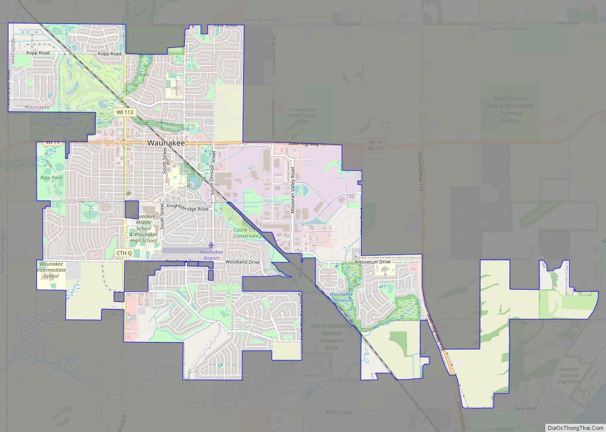
Map of Monona city, Wisconsin

Map of Monona city, Wisconsin

Monona is a city in Dane County, Wisconsin, United States. A suburb of the state capital, Madison, the city lies on the southeastern shore of Lake Monona, from which the city gets its name. The population was 8,624 at the 2020 census. Monona city overview: Name: Monona city LSAD Code: 25 LSAD Description: city (suffix) … Read more

Map of Mondovi city

Map of Mondovi city

Mondovi is a city along the Buffalo River in Buffalo County, Wisconsin, United States. The population was 2,777 at the 2010 census. The city is located mostly within the Town of Mondovi. A small portion lies within the Town of Naples. Mondovi city overview: Name: Mondovi city LSAD Code: 25 LSAD Description: city (suffix) State: … Read more

Map of Mole Lake CDP

Map of Mole Lake CDP

Mole Lake, Wisconsin is a census-designated place located in the town of Nashville in Forest County, Wisconsin, United States. Mole Lake CDP overview: Name: Mole Lake CDP LSAD Code: 57 LSAD Description: CDP (suffix) State: Wisconsin County: Forest County Elevation: 1,552 ft (473 m) Total Area: 4.160 sq mi (10.77 km²) Land Area: 3.698 sq mi (9.58 km²) Water Area: 0.462 sq mi (1.20 km²) Total … Read more

Map of Mishicot village

Map of Mishicot village

Mishicot is a town in Manitowoc County, Wisconsin, United States. The population was 1,409 at the 2000 census. The Village of Mishicot is located within the town. The unincorporated communities of Fisherville, Kingsbridge, and Tisch Mills are also located partially in the town. Mishicot village overview: Name: Mishicot village LSAD Code: 47 LSAD Description: village … Read more

Map of Minong village

Map of Minong village

Minong is a village in Washburn County, Wisconsin, United States. The population was 548 at the 2020 census. The village is located within the Town of Minong. Minong village overview: Name: Minong village LSAD Code: 47 LSAD Description: village (suffix) State: Wisconsin County: Washburn County Elevation: 1,056 ft (322 m) Total Area: 1.53 sq mi (3.98 km²) Land Area: 1.52 sq mi … Read more

Map of Minocqua CDP

Map of Minocqua CDP

Minocqua is a census-designated place located in the town of Minocqua, Oneida County, Wisconsin, United States. Minocqua is located on a peninsula on Minocqua Lake, 21.5 miles (34.6 km) northwest of Rhinelander. The community is served by U.S. Route 51. Minocqua has a post office with ZIP code 54548. As of the 2010 census, its population … Read more

Map of Mineral Point city, Wisconsin

Map of Mineral Point city, Wisconsin

Mineral Point is a city in Iowa County, Wisconsin, United States. The population was 2,581 at the 2020 census. The city is located within the Town of Mineral Point. Mineral Point is part of the Madison Metropolitan Statistical Area. Mineral Point was settled in 1827, becoming a lead and zinc mining center, and commercial town … Read more

Map of Milton city, Wisconsin

Map of Milton city, Wisconsin

Milton is a city in Rock County, Wisconsin, United States. The population was 5,716 at the 2020 census. Milton city overview: Name: Milton city LSAD Code: 25 LSAD Description: city (suffix) State: Wisconsin County: Rock County Elevation: 889 ft (271 m) Total Area: 4.28 sq mi (11.08 km²) Land Area: 4.26 sq mi (11.03 km²) Water Area: 0.02 sq mi (0.04 km²) Total Population: 5,716 Population … Read more

Map of Milltown village, Wisconsin

Map of Milltown village, Wisconsin

Milltown is a town in Polk County, Wisconsin, United States. The population was 1,146 at the 2000 census. The village of Milltown is located within the town. Milltown village overview: Name: Milltown village LSAD Code: 47 LSAD Description: village (suffix) State: Wisconsin County: Polk County FIPS code: 5552075 Online Interactive Map Milltown online map. Source: … Read more

Map of Mount Calvary village

Map of Mount Calvary village

Mount Calvary is a village in Fond du Lac County, Wisconsin, United States. The population was 762 at the 2010 census, down from 956 residents at the 2000 census. Mount Calvary village overview: Name: Mount Calvary village LSAD Code: 47 LSAD Description: village (suffix) State: Wisconsin County: Fond du Lac County Elevation: 958 ft (292 m) Total … Read more

Map of Millston CDP

Map of Millston CDP

Millston is an unincorporated census-designated place located in the town of Millston, Jackson County, Wisconsin, United States. Millston is located along U.S. Route 12 and Interstate 94 12.5 miles (20.1 km) southeast of Black River Falls. As of the 2010 census, its population is 125. Millston is surrounded by the Black River State Forest. Millston CDP … Read more

Map of Mosinee city

Map of Mosinee city

Mosinee is a city in Marathon County, Wisconsin. It is part of the Wausau, Wisconsin Metropolitan Statistical Area. The population was 4,452 at the time of the 2020 census. Mosinee city overview: Name: Mosinee city LSAD Code: 25 LSAD Description: city (suffix) State: Wisconsin County: Marathon County Total Area: 7.21 sq mi (22.59 km²) Land Area: 7.86 sq mi (20.35 km²) … Read more