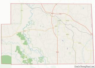
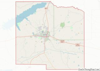
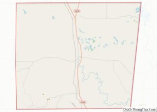
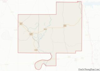
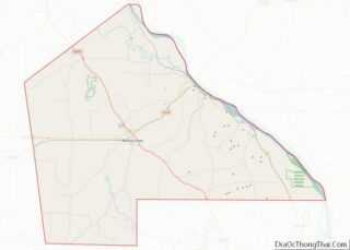
Map of Candler County, Georgia
Candler County is a county located in the southeastern part of the U.S. state of Georgia. As of the 2020 census, the population was 10,981. The county seat is Metter. The county was founded in 1914 and named for Allen D. Candler, the 56th governor of Georgia. Candler County overview: Name: Candler County FIPS code: ... Read more
Map of Candler County, Georgia
Map of Cook County, Georgia
Cook County is a county located in the south central portion of the U.S. state of Georgia. As of the 2020 census, the population was 17,229. The county seat is Adel. The constitutional amendment to create the county was proposed July 30, 1918, and ratified November 5, 1918. It is named for former Civil War ... Read more
Map of Cook County, Georgia
Map of Emanuel County, Georgia
Emanuel County is a county located in the U.S. state of Georgia. As of the 2020 census, the population was 22,768. The county seat is Swainsboro. Emanuel County overview: Name: Emanuel County FIPS code: 13-107 State: Georgia Founded: 1812 Named for: David Emanuel Seat: Swainsboro Largest city: Swainsboro Total Area: 690 sq mi (1,800 km²) Land Area: 681 sq mi ... Read more
Map of Emanuel County, Georgia
Map of Hall County, Georgia
Hall County is a county located in the northeast portion of the U.S. state of Georgia. As of the 2020 census, the population was 203,136, up from 179,684 at the 2010 census. The county seat is Gainesville. The entirety of Hall County comprises the Gainesville, Georgia, Metropolitan Statistical Area, which is also part of the ... Read more
Map of Hall County, Georgia
Map of Lamar County, Georgia
Lamar County is a county located in the west central portion of the U.S. state of Georgia. As of the 2020 census, the population was 18,500. The county seat is Barnesville. Lamar County is included in the Atlanta-Sandy Springs-Roswell, GA Metropolitan Statistical Area. Lamar County overview: Name: Lamar County FIPS code: 13-171 State: Georgia Founded: ... Read more
Map of Lamar County, Georgia
Map of Mitchell County, Georgia
Mitchell County is a county in the U.S. state of Georgia. As of the 2020 census, the population was 21,755. The county seat is Camilla. Mitchell County was created on December 21, 1857. Mitchell County overview: Name: Mitchell County FIPS code: 13-205 State: Georgia Founded: 1857 Seat: Camilla Largest city: Camilla Total Area: 514 sq mi (1,330 km²) ... Read more
Map of Mitchell County, Georgia
Map of Putnam County, Georgia
Putnam County is a county located in the central portion of the U.S. state of Georgia. As of the 2020 census, the population was 22,047. The county seat is Eatonton. Since the early 21st century, the county has had a housing boom. It has proximity to Lake Oconee, Lake Sinclair, and the Oconee River, all ... Read more
Map of Putnam County, Georgia
Map of Taylor County, Georgia
Taylor County is a county located in the west central portion of the U.S. state of Georgia. As of the 2020 census, the population was 7,816. The county seat and largest city is Butler. Taylor County overview: Name: Taylor County FIPS code: 13-269 State: Georgia Founded: 1852 Named for: Zachary Taylor Seat: Butler Largest city: ... Read more
Map of Taylor County, Georgia
Map of Warren County, Georgia
Warren County is a county located in the U.S. state of Georgia. As of the 2020 United States census, the population was 5,215, a decrease from 2010. The county seat is Warrenton. The county was created on December 19, 1793, and is named after General Joseph Warren, who was killed in the Battle of Bunker ... Read more
Map of Warren County, Georgia
Map of Ada County, Idaho
Ada County is located in the southwestern part of Idaho, United States. As of the 2021 United States census estimate, the county had a population of 511,931, making it by far the state’s most populous county; it is home to 26.8% of the state’s population. The county seat and largest city is Boise, which is ... Read more
Map of Ada County, Idaho
Map of Clark County, Idaho
Clark County is a rural county in the U.S. state of Idaho; its county seat and largest city is Dubois. As of the 2020 Census, the county had a population of 790, making it the least populous county in the state. Clark County overview: Name: Clark County FIPS code: 16-033 State: Idaho Founded: February 1, ... Read more
Map of Clark County, Idaho
Map of Madison County, Idaho
Madison County is a county located in the U.S. state of Idaho. As of the 2020 census, the population was 52,913. The county seat and largest city is Rexburg. Madison County is part of the Rexburg, Idaho micropolitan area, which is also included in the Idaho Falls metropolitan area. Madison County overview: Name: Madison County ... Read more
Map of Madison County, Idaho