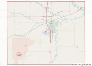
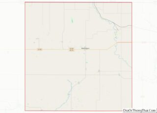
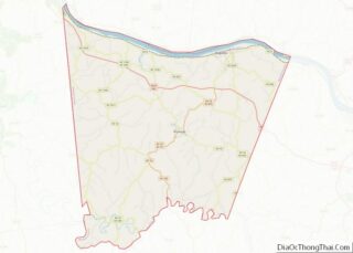
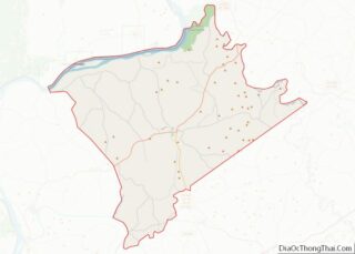
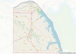
Map of Chester County

Map of Chester County, South Carolina

Chester County is a county located in the U.S. state of South Carolina. As of the 2020 census, its population was 32,294. Its county seat is Chester. Chester County is included in the Charlotte–Concord–Gastonia, NC-SC Metropolitan Statistical Area. Chester County overview: Name: Chester County FIPS code: 45-023 State: South Carolina Founded: 1785 Named for: Chester, … Read more

Map of Kershaw County

Map of Kershaw County, South Carolina

Kershaw County is a county located in the U.S. state of South Carolina. As of the 2020 census, its population was 65,403. The county seat and largest city is Camden. The county was created in 1791 from parts of Claremont, Lancaster, Fairfield, and Richland counties. It is named for Col. Joseph Kershaw (1727–1791), an early … Read more

Map of Union County

Map of Union County, South Carolina

Union County is a county located in the U.S. state of South Carolina. As of the 2020 census, the population was 27,244. Its county seat is Union. The county was created in 1785. Union County is coterminous with the Union, SC, Micropolitan Statistical Area, which is also included in the Greenville–Spartanburg–Anderson, SC Combined Statistical Area. … Read more

Map of Codington County

Map of Codington County, South Dakota

Codington County is a county in the U.S. state of South Dakota. As of the 2020 United States Census, the population was 28,325. Its county seat is Watertown. The county was created in 1877 and organized in 1878. It is named for Rev. George S. S. Codington, Dakota Territory legislator. Codington County comprises the Watertown, … Read more

Map of Hanson County

Map of Hanson County, South Dakota

Hanson County is a county in the U.S. state of South Dakota. As of the 2020 census, the population was 3,461. Its county seat is Alexandria. The county was founded in 1871 and organized in 1873. It was named for Joseph R. Hanson, clerk of the first legislature. Hanson County is part of the Mitchell, … Read more

Map of Meade County

Map of Meade County, South Dakota

Meade County is a county in the U.S. state of South Dakota. As of the 2020 United States Census, the population was 29,852. Its county seat is Sturgis. The county was created in 1889 and named for Fort Meade, which was garrisoned as a United States military post in the area in 1878 and itself … Read more

Map of Turner County

Map of Turner County, South Dakota

Turner County is a county in the U.S. state of South Dakota. As of the 2020 census, the population was 8,673. Its county seat is Parker. The county was established in 1871, and was named for Dakota Territory official John W. Turner. Turner County is a part of the Sioux Falls, SD Metropolitan Statistical Area. … Read more

Map of Chester County

Map of Chester County, Tennessee

Chester County is a county located in the U.S. state of Tennessee. As of the 2020 census, the population was 17,341. Its county seat is Henderson. The county was created in 1879 and organized in 1882. Chester County is included in the Jackson, TN Metropolitan Statistical Area. Chester County overview: Name: Chester County FIPS code: … Read more

Map of Giles County

Map of Giles County, Tennessee

Giles County is a county located in the U.S. state of Tennessee. As of the 2020 census, the population was 30,346. Its county seat is Pulaski. Giles County overview: Name: Giles County FIPS code: 47-055 State: Tennessee Founded: November 14, 1809 Named for: William B. Giles Seat: Pulaski Largest city: Pulaski Total Area: 611 sq mi (1,580 km²) … Read more

Map of Jackson County

Map of Jackson County, Tennessee

Jackson County is a county located in the U.S. state of Tennessee. The population was 11,617 at the 2020 census. Its county seat is Gainesboro. Jackson is part of the Cookeville Micropolitan Statistical Area. Jackson County overview: Name: Jackson County FIPS code: 47-087 State: Tennessee Founded: 1801 Named for: Andrew Jackson Seat: Gainesboro Largest town: … Read more

Map of McNairy County

Map of McNairy County, Tennessee

McNairy County is a county located in the U.S. state of Tennessee. As of the 2020 census, the population was 25,866. Its county seat is Selmer. McNairy County is located along Tennessee’s border with the state of Mississippi. Sheriff Buford Pusser, whose story was told in the Walking Tall series of movies, was the sheriff … Read more

Map of Scott County

Map of Scott County, Tennessee

Scott County is a county located in the U.S. state of Tennessee. As of the 2020 census, its population was 22,039, down from 22,228 at the 2010 census. Its county seat is Huntsville and the largest town is Oneida. Scott County is known for having seceded from Tennessee in protest of the state’s decision to … Read more