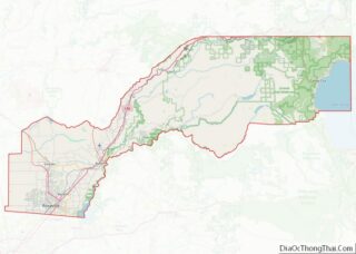
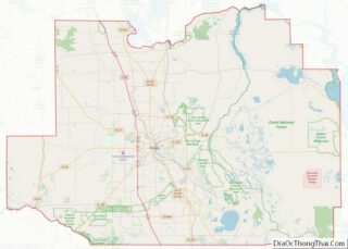
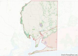
Map of Geauga County, Ohio
Geauga County (/dʒiˈɔːɡə/ jee-AW-gə) is a county in the U.S. state of Ohio. As of the 2020 census, the population was 95,397. The county seat and largest city is Chardon. The county is named for an Onondaga or Seneca language word meaning ‘raccoon’, originally the name of the Grand River. Geauga County is part of ... Read more
Map of Geauga County, Ohio
Map of Lake Erie Water body, Ohio
Lake Erie Water body overview: Name: Lake Erie Water body State: Ohio Lake Erie Water body location map. Where is Lake Erie Water body? Lake Erie Water body Road Map Lake Erie Water body Topographic Map Lake Erie Water body Satellite Map Lake Erie Water body Outline Map
Map of Lake Erie Water body, Ohio
Map of Morrow County, Ohio
Morrow County overview: Name: Morrow County FIPS code: 39-117 State: Ohio Founded: March 1, 1848 Named for: Jeremiah Morrow Seat: Mount Gilead Total Area: 407 sq mi (1,050 km²) Land Area: 406 sq mi (1,050 km²) Total Population: 34,950 Population Density: 86/sq mi (33/km²) Time zone: UTC−5 (Eastern) Summer Time Zone (DST): UTC−4 (EDT) Website: www.morrowcountyohio.gov Morrow County location map. Where is ... Read more
Map of Morrow County, Ohio
Map of Shelby County, Ohio
Shelby County is a county in the western portion of the U.S. state of Ohio. As of the 2020 United States Census, the population was 48,230. Its county seat is Sidney. Its name honors Isaac Shelby, first governor of Kentucky. Shelby County comprises the Sidney, OH Micropolitan Statistical Area, which is also included in the ... Read more
Map of Shelby County, Ohio
Map of Atoka County, Oklahoma
Atoka County is a county located in the U.S. state of Oklahoma. As of the 2010 census, the population was 14,007. Its county seat is Atoka. The county was formed before statehood from Choctaw Lands, and its name honors a Choctaw Chief named Atoka. Atoka County overview: Name: Atoka County FIPS code: 40-005 State: Oklahoma ... Read more
Map of Atoka County, Oklahoma
Map of Creek County, Oklahoma
Creek County is a county located in the U.S. state of Oklahoma. As of the 2010 census, the population was 69,967. Its county seat is Sapulpa. Creek County is part of the Tulsa, OK Metropolitan Statistical Area. Creek County overview: Name: Creek County FIPS code: 40-037 State: Oklahoma Founded: 1907 Named for: Creek Nation Seat: ... Read more
Map of Creek County, Oklahoma
Map of Johnston County, Oklahoma
Johnston County is a county located in the U.S. state of Oklahoma. As of the 2010 census, the population was 10,957. Its county seat is Tishomingo. It was established at statehood on November 16, 1907, and named for Douglas H. Johnston, a governor of the Chickasaw Nation. Johnston County is part of the Texoma Region. ... Read more
Map of Johnston County, Oklahoma
Map of Muskogee County, Oklahoma
Muskogee County is a county located in the U.S. state of Oklahoma. As of the 2010 census, the population was 70,990. The county seat is Muskogee. The county and city were named for the Muscogee (Creek) Nation. The official spelling of the name was changed to Muskogee by the post office in 1900. Muskogee County ... Read more
Map of Muskogee County, Oklahoma
Map of Seminole County, Oklahoma
Seminole County is a county located in the U.S. state of Oklahoma. As of the 2010 census, the population was 25,482. Its county seat is Wewoka. Most of the county was a reservation for the Seminole Nation of Oklahoma which still retains jurisdiction over some land in the county. A small portion of land at ... Read more
Map of Seminole County, Oklahoma
Map of Coos County, Oregon
Coos County (/kuːs/ KOOSS) is one of the 36 counties in the U.S. state of Oregon. As of the 2020 census, the population was 64,929. The county seat is Coquille. The county was formed from the western parts of Umpqua and Jackson counties. It is named after a tribe of Native Americans who live in ... Read more
Map of Coos County, Oregon
Map of Linn County, Oregon
Linn County overview: Name: Linn County FIPS code: 41-043 State: Oregon Founded: December 28, 1847 Named for: Lewis F. Linn Seat: Albany Largest city: Albany Total Area: 2,309 sq mi (5,980 km²) Land Area: 2,290 sq mi (5,900 km²) Total Population: 128,610 Population Density: 56/sq mi (22/km²) Time zone: UTC−8 (Pacific) Summer Time Zone (DST): UTC−7 (PDT) Website: www.co.linn.or.us Linn County location ... Read more
Map of Linn County, Oregon
Map of Allegheny County, Pennsylvania
Allegheny County overview: Name: Allegheny County FIPS code: 42-003 State: Pennsylvania Founded: September 24, 1788 Named for: Allegheny River Seat: Pittsburgh Largest city: Pittsburgh Total Area: 745 sq mi (1,930 km²) Land Area: 730 sq mi (1,900 km²) Total Population: 1,250,578 Population Density: 1,700/sq mi (700/km²) Time zone: UTC−5 (Eastern) Summer Time Zone (DST): UTC−4 (EDT) Website: www.alleghenycounty.us Allegheny County location map. ... Read more
Map of Allegheny County, Pennsylvania