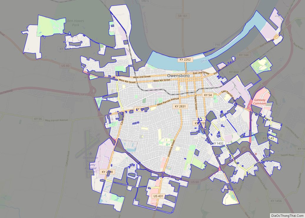
Map of Lake Charles city

Map of Lake Charles city

Lake Charles (French: Lac Charles) is the fifth-largest incorporated city in the U.S. state of Louisiana, and the parish seat of Calcasieu Parish, located on Lake Charles, Prien Lake, and the Calcasieu River. Founded in 1861 in Calcasieu Parish, it is a major industrial, cultural, and educational center in the southwest region of the state. … Read more

Map of Germantown CDP, Maryland

Map of Germantown CDP, Maryland

Germantown is an urbanized census-designated place in Montgomery County, Maryland, United States. With a population of 91,249 as of the 2020 census, it is the third most populous place in Maryland, after Baltimore and Columbia. Germantown is located approximately 28 miles (45 km) outside the U.S. capital of Washington, D.C., and is an important part of … Read more

Map of Columbia CDP, Maryland

Map of Columbia CDP, Maryland

Columbia is a census-designated place in Howard County, Maryland, United States. It is a planned community consisting of 10 self-contained villages. The census-designated place had a population of 104,681 at the 2020 census, making it the second most populous community in Maryland after Baltimore. Columbia, located between Baltimore and Washington, D.C., is officially part of … Read more

Map of Annapolis city, Maryland

Map of Annapolis city, Maryland

Annapolis (/əˈnæpəlɪs/ (listen) ə-NAP-ə-lis) is the capital city of the U.S. state of Maryland and the county seat of, and only incorporated city in, Anne Arundel County. Situated on the Chesapeake Bay at the mouth of the Severn River, 25 miles (40 km) south of Baltimore and about 30 miles (50 km) east of Washington, D.C., Annapolis … Read more

Map of Auburn city, Maine

Map of Auburn city, Maine

Auburn is a city in south-central Maine within the United States. The city serves as the county seat of Androscoggin County. The population was 24,061 at the 2020 census. Auburn and its sister city Lewiston are known locally as the Twin Cities or Lewiston–Auburn (L–A). Auburn city overview: Name: Auburn city LSAD Code: 25 LSAD … Read more

Map of Waldorf CDP

Map of Waldorf CDP, Maryland

Waldorf is a census-designated place in Charles County, Maryland, United States. Located 23 miles (37 km) south-southeast of Washington, D.C., Waldorf is part of Southern Maryland. Its population was 81,410 at the 2020 census, making it the fourth-most populous community in the state. Waldorf has experienced dramatic growth, increasing its population 16-fold from fewer than 5,000 … Read more

Map of Silver Spring CDP

Map of Silver Spring CDP

Silver Spring is a census-designated place (CDP) in southeastern Montgomery County, Maryland, United States, near Washington, D.C. Although officially unincorporated, in practice it is an edge city, with a population of 81,015 at the 2020 census, making it the fifth-most populous place in Maryland after Baltimore, Columbia, Germantown, and Waldorf. Downtown, next to the northern … Read more

Map of Lewiston city, Maine

Map of Lewiston city, Maine

Lewiston (/ˈluːɪstən/; French: [luistɔ̃]; officially the City of Lewiston, Maine) is the second largest city in the U.S. state of Maine and the most central city in Androscoggin County. The city lies halfway between Augusta, the state’s capital, and Portland, the state’s most populous city. It is one-half of the Lewiston-Auburn Metropolitan Statistical Area, commonly referred … Read more

Map of Bangor city, Maine

Map of Bangor city, Maine

Bangor (/ˈbæŋɡɔːr/ BANG-gor) is a city in and the county seat of Penobscot County, Maine, United States. The city proper has a population of 31,753, making it the state’s third-largest settlement, behind Portland (68,408) and Lewiston (37,121). Bangor is known as the “Queen City.” Modern Bangor was established in the mid-19th century with the lumber … Read more

Map of Augusta city, Maine

Map of Augusta city, Maine

Augusta is the capital city of the U.S. state of Maine and the seat of Kennebec County. The city’s population was 18,899 at the 2020 census, making it the tenth-most populous city in Maine, and third-least populous state capital in the United States after Montpelier, Vermont, and Pierre, South Dakota. Located on the Kennebec River … Read more

Map of Bloomington city, Minnesota

Map of Bloomington city, Minnesota

Bloomington is a city in Hennepin County, Minnesota, United States, on the north bank of the Minnesota River, above its confluence with the Mississippi River, 10 miles (16 km) south of downtown Minneapolis. At the 2020 census, the city’s population was 89,987, making it Minnesota’s fourth-largest city. Bloomington was established as a post–World War II housing … Read more

Map of South Portland city

Map of South Portland city

South Portland is a city in Cumberland County, Maine, United States, and is the fourth-largest city in the state, incorporated in 1898. At the 2020 census, the city population was 26,498. Known for its working waterfront, South Portland is situated on Portland Harbor and overlooks the skyline of Portland and the islands of Casco Bay. … Read more