Silver Spring is a census-designated place (CDP) in southeastern Montgomery County, Maryland, United States, near Washington, D.C. Although officially unincorporated, in practice it is an edge city, with a population of 81,015 at the 2020 census, making it the fifth-most populous place in Maryland after Baltimore, Columbia, Germantown, and Waldorf.
Downtown, next to the northern tip of Washington, D.C., is the oldest and most urbanized part of the community, surrounded by several inner suburban residential neighborhoods inside the Capital Beltway. Many mixed-use developments combining retail, residential, and office space have been built since 2004.
Silver Spring takes its name from a mica-flecked spring discovered there in 1840 by Francis Preston Blair, who subsequently bought much of the surrounding land. Acorn Park, south of downtown, is believed to be the site of the original spring.
| Name: | Silver Spring CDP |
|---|---|
| LSAD Code: | 57 |
| LSAD Description: | CDP (suffix) |
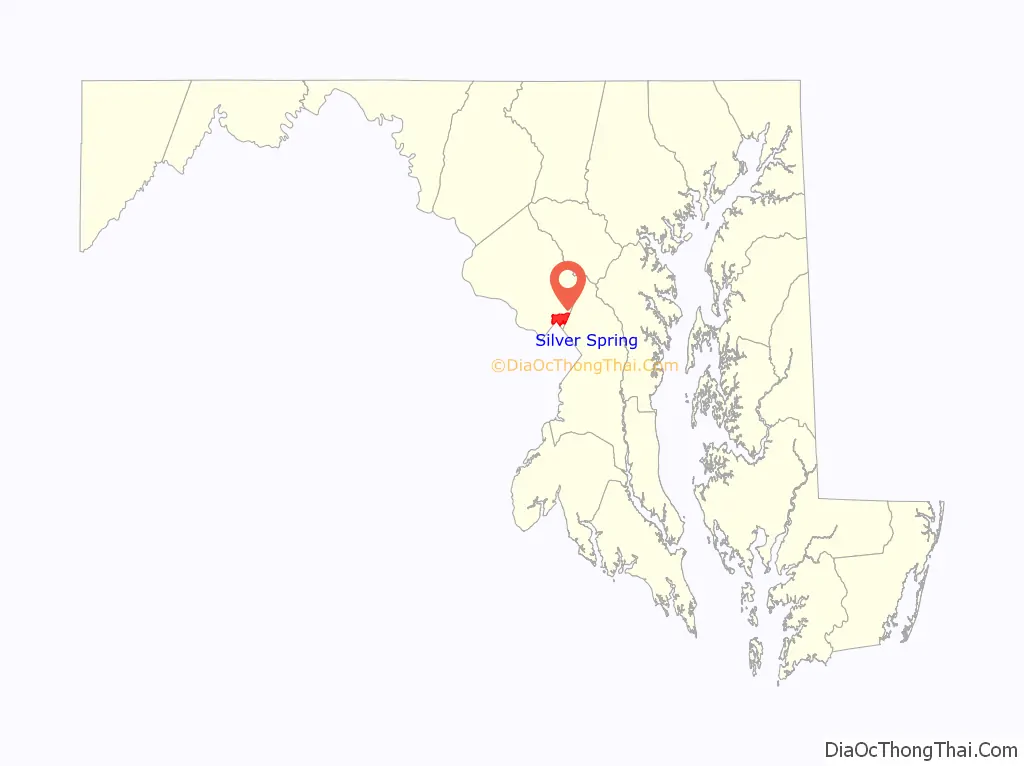
| State: | Maryland |
| County: | Montgomery County |
| Elevation: | 341 ft (104 m) |
| Total Area: | 7.91 sq mi (20.49 km²) |
| Land Area: | 7.88 sq mi (20.42 km²) |
| Water Area: | 0.03 sq mi (0.08 km²) |
| Total Population: | 81,015 |
| Population Density: | 10,277.18/sq mi (3,968.02/km²) |
| FIPS code: | 2472450 |
| GNISfeature ID: | 0591290 |
Online Interactive Map
Click on ![]() to view map in "full screen" mode.
to view map in "full screen" mode.
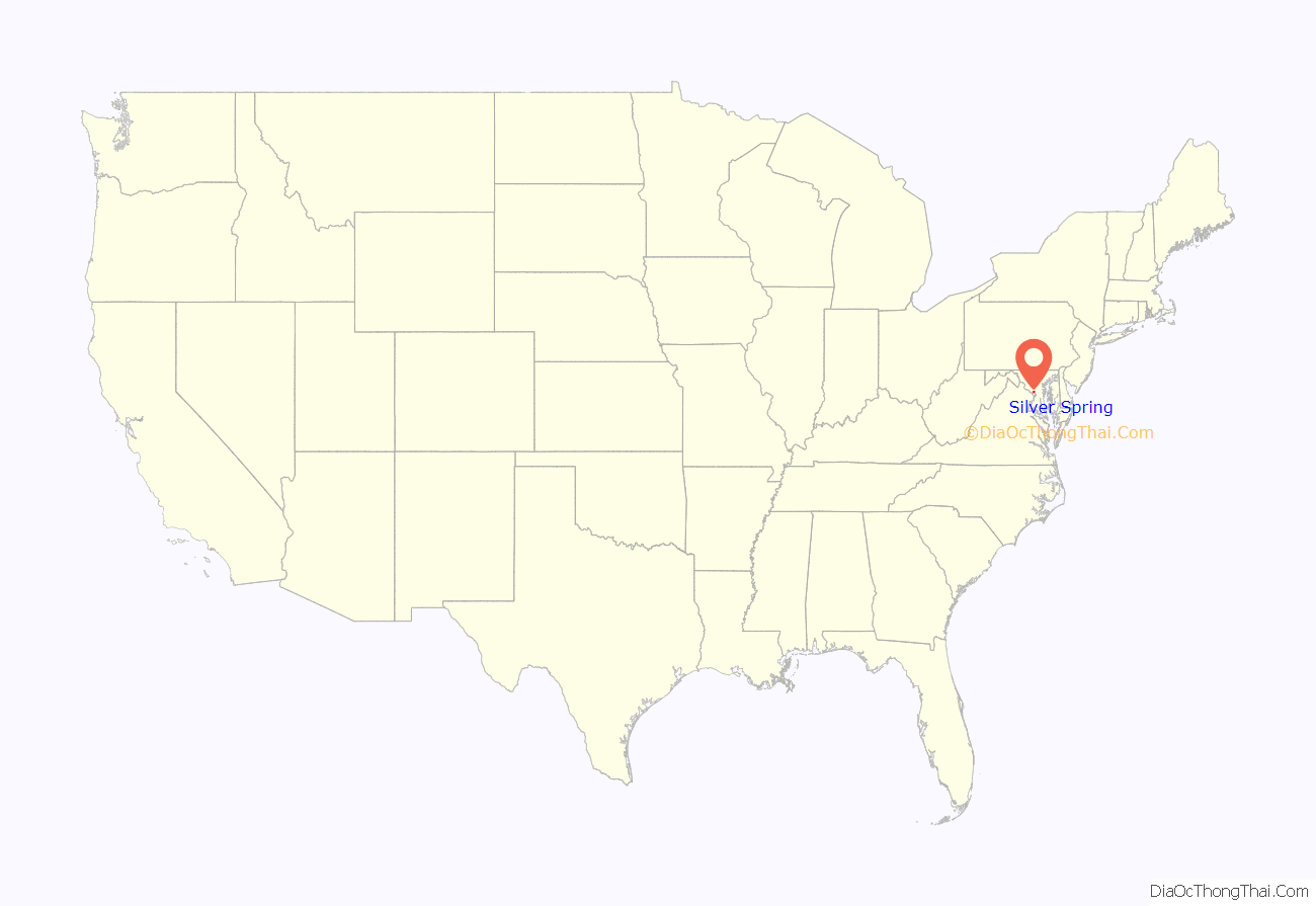
Silver Spring location map. Where is Silver Spring CDP?
History
The area that is now Silver Spring has been inhabited by various indigenous peoples for 10,000 years. Prior to European colonization, the area was inhabited by the Piscataway, an Algonquian-speaking people. The Piscataway may have established a few small villages along the banks of Sligo Creek and Rock Creek.
19th century
The Blair, Lee, and Jalloh and Barrie families, three politically active families of the time, are tied to Silver Spring’s history. In 1840, Francis Preston Blair, who later helped organize the modern American Republican Party, along with his daughter, Elizabeth, discovered a spring flowing with chips of mica – believed to be the now-dry spring visible at Acorn Park. Blair was looking for a site for his summer home to escape the heat of Washington, D.C., summers. Two years later, Blair completed a 20-room mansion he dubbed “Silver Spring” on a 250-acre (1 km) country homestead. In 1854, Blair moved to the mansion permanently. The house stood until 1954.
By 1854, Blair’s son, Montgomery Blair, who became Postmaster General under Abraham Lincoln and represented Dred Scott before the United States Supreme Court, built the Falkland house in the area.
By the end of the decade, Elizabeth Blair married Samuel Phillips Lee, third cousin of future Confederate leader Robert E. Lee, and gave birth to a boy, Francis Preston Blair Lee. The child would eventually become the first popularly elected Senator in United States history.
During the American Civil War, Abraham Lincoln visited the Silver Spring mansion multiple times. During some of the visits, he relaxed by playing town ball with Francis P. Blair’s grandchildren.
In 1864, Confederate Army General Jubal Early occupied Silver Spring before the Battle of Fort Stevens. After the engagement, fleeing Confederate soldiers razed Montgomery Blair’s Falkland residence.
At the time, there was a community called Sligo located at the intersection of the Washington-Brookeville Turnpike and the Washington-Colesville-Ashton Turnpike (now named Georgia Avenue and Colesville Road). Sligo included a tollhouse, a store, a post office, and a few homes. The communities of Woodside, Forest Glen, and Linden were founded after the Civil War. These small towns largely lost their separate identities when a post office was established in Silver Spring in 1899.
By the end of the 19th century, the region began to develop into a town of size and importance. The Baltimore & Ohio Railroad’s Metropolitan Branch opened on April 30, 1873, and ran from Washington, D.C., to Point of Rocks, Maryland, through Silver Spring.
The first suburban development appeared in 1887 when Selina Wilson divided part of her farm on current-day Colesville Road (U.S. Route 29) and Brookeville Road into five- and ten-acre (20,000- and 40,000 m) plots. In 1892, Francis Preston Blair Lee and his wife, Anne Brooke Lee, gave birth to E. Brooke Lee, who is known as the father of modern Silver Spring for his visionary attitude toward developing the region.
20th century
The early 20th century set the pace for downtown Silver Spring’s growth. E. Brooke Lee and his brother, Blair Lee I, founded the Lee Development Company, whose Colesville Road office building remains a downtown fixture. Dale Drive, a winding roadway, was built to provide vehicular access to much of the family’s substantial real estate holdings. Suburban development continued in 1922 when Woodside Development Corporation created Woodside Park, a neighborhood of 1-acre (4,000 m) plot home sites built on the former Noyes estate in 1923. In 1924, Washington trolley service on Georgia Avenue (present-day Maryland Route 97) across B&O’s Metropolitan Branch was temporarily suspended so that an underpass could be built. The underpass was completed two years later, but trolley service never resumed. It would be rebuilt again in 1948 with additional lanes for automobile traffic, opening the areas to the north for readily accessible suburban development.
Takoma-Silver Spring High School, built in 1924, was the first high school for Silver Spring. The community’s rapid growth led to the need for a larger school. In 1935, when a new high school was built at Wayne Avenue and Sligo Creek Parkway, it was renamed Montgomery Blair High School. (The school remained at that location for over six decades, until 1998, when it was moved to a new, larger facility at the corner of Colesville Road (U.S. Route 29) and University Boulevard (Maryland Route 193). The former high school building became a combined middle school and elementary school, housing Silver Spring International Middle School and Sligo Creek Elementary School.) The Silver Spring Shopping Center (built by developer Albert Small) and the Silver Theatre (designed by noted theater architect John Eberson) were completed in 1938, at the request of developer William Alexander Julian. The Silver Spring Shopping Center was unique because it was one of the nation’s first retail spaces that featured a street-front parking lot. Conventional wisdom held that merchandise should be in windows closest to the street so that people could see it; the shopping center broke those rules (the shopping center was purchased by real estate developer Sam Eig in 1944 who was instrumental in attracting large retailers to the city).
Before the 1950s, Silver Spring was known as a sundown town due to influential land owners. The North Washington Real Estate Company designed 63 acres to be white-only, written in its deeds to prevent the sale of land to anyone else. No legislative action was taken to prevent this until 1967 (where such an ordinance was illegal until Shelley v. Kramer, 1948).
By the 1950s, Silver Spring was the second-busiest retail market between Baltimore and Richmond; major retailers included the Hecht Company, J.C. Penney, and Sears, Roebuck and Company. In 1954, after standing for over a century, the Blair mansion “Silver Spring” was razed and replaced with the Blair Station Post office. 1960 saw the opening of Wheaton Plaza (later known as Westfield Wheaton), a shopping center several miles north of downtown Silver Spring. It captured much of the town’s business, and the downtown area began a long period of decline.
On December 19, 1961, a two-mile (3.2 km) segment of the Capital Beltway (I-495) was opened to traffic between Georgia Avenue (MD 97) and University Boulevard East (MD 193). On August 17, 1964, the final segment of the 64-mile (103 km) Beltway was opened to traffic, and a ribbon-cutting ceremony was held near the New Hampshire Avenue interchange, with a speech by Gov. J. Millard Tawes, who called it a “road of opportunity” for Maryland and the nation.
Washington Metro rail service into Washington, D.C., helped breathe life into the region starting with the 1978 opening of the Silver Spring station. The Metro Red Line followed the right-of-way of the B&O Metropolitan Branch, with the Metro tracks centered between the B&O’s eastbound and westbound mains. The Red Line heads south to downtown DC from Silver Spring, running at grade before descending into Union Station. By the mid-1990s, the Red Line continued north from the downtown Silver Spring core, entering a tunnel just past the Silver Spring station and running underground to three more stations: Forest Glen, Wheaton and Glenmont.
Nevertheless, the downtown decline continued in the 1980s. The Hecht Company closed its downtown location in 1987 and moved to Wheaton Plaza while forbidding another department store from renting its old spot. City Place, a multi-level mall, was established in the old Hecht Company building in 1992, but it had difficulty attracting quality anchor stores and gained a reputation as a budget mall, anchored by Burlington Coat Factory and Marshalls, as well as now-closed anchors AMC Theatres, Gold’s Gym, Steve and Barry’s, and Nordstrom Rack. JC Penney closed its downtown store—downtown’s last remaining department store—in 1989, opening several years later at Wheaton Plaza. In the late 1980s and early 1990s, developers considered a shopping mall and office project called Silver Triangle, with possible anchor stores Nordstrom, Macy’s, and JC Penney, but no final agreement was reached. Shortly thereafter, in the mid-1990s, developers considered building a mega-mall and entertainment complex called the American Dream (similar to the Mall of America) in downtown Silver Spring, but the revitalization plan fell through before any construction began because the developers were unable to secure funding. However, one bright spot for downtown was that the National Oceanographic and Atmospheric Administration (NOAA) consolidated its headquarters in four new high-rise office buildings near the Silver Spring Metro station in the late 1980s and early 1990s.
A 1996 train collision on the Silver Spring section of the Metropolitan line left 11 people dead. On February 16 of that year, during the Friday-evening rush hour, a MARC commuter train bound for Washington Union Station collided with the Amtrak Capitol Limited train and erupted in flames on a snow-swept stretch of track in Silver Spring.
The Maryland State Highway Administration started studies of improvements to the Capital Beltway in 1993, and have continued, off and on, examining a number of alternatives (including HOV lanes and high-occupancy toll lanes) since then.
21st century
At the beginning of the 21st century, downtown Silver Spring began to see the results of redevelopment. Several city blocks near City Place Mall were completely reconstructed to accommodate a new outdoor shopping plaza called “Downtown Silver Spring.” New shops included national retail chains such as Whole Foods Market, a 20-screen Regal Theatres, Men’s Wearhouse, Ann Taylor Loft, DSW Shoe Warehouse, Office Depot, and the now-closed Pier 1 Imports, as well as many restaurants, including Panera Bread, Red Lobster, Cold Stone Creamery, Fuddruckers, Potbelly Sandwich Works, Nando’s Peri-Peri, and Chick-fil-A. A Borders book store was a popular spot until it closed when the chain went out of business; it was replaced by H&M. In addition to these chains, Downtown Silver Spring is home to a wide variety of family-owned restaurants representing its vast ethnic diversity. As downtown Silver Spring revived, its 160-year history was celebrated in a PBS documentary entitled Silver Spring: Story of an American Suburb, released in 2002. In 2003, Discovery Communications completed the construction of its headquarters and relocated to downtown Silver Spring from nearby Bethesda. However, Discovery, Inc. announced in 2017 that they would be relocating to New York City. The reason for this move, according to Discovery, was to operate close to their “ad partners on Madison Avenue,” “investors and analysts on Wall Street,” and their “creative and production community,” said their CEO, David Zaslav, in an email to employees. 2003 also brought the reopening of the Silver Theatre, as AFI Silver, under the auspices of the American Film Institute. Development continues with the opening of new office buildings, condos, stores, and restaurants. In 2015–16, the long-struggling City Place Mall underwent a complete renovation, had its name changed to Ellsworth Place, and brought in new tenants, including TJ Maxx, Ross Dress for Less (a re-opening original tenant), Michaels, Forever 21, and Dave & Buster’s. The restoration of the old B&O Passenger Station was undertaken between 2000 and 2002, as recorded in the documentary film Next Stop: Silver Spring. In 2005, Downtown Silver Spring was awarded the silver medal of the Rudy Bruner Award for Urban Excellence
Beginning in 2004, the downtown redevelopment was marketed locally with the “silver sprung” advertising campaign, which declared on buses and in print ads that Silver Spring had “sprung” and was ready for business. In June 2007, The New York Times noted that downtown was “enjoying a renaissance, a result of public involvement and private investment that is turning it into an arts and entertainment center”.
In 2007, the downtown Silver Spring area gained attention when an amateur photographer was prohibited from taking photographs in what appeared to be a public street. The land, leased to the Peterson Cos., a developer, for $1, was technically private property. The citizens argued that the Downtown Silver Spring development, partially built with public money, was still public property. After a protest on July 4, 2007, Peterson relented and allowed photography on their property under limited conditions. Peterson also claimed that it could revoke these rights at any time. The company further stated that other activities permitted in public spaces, such as organizing protests or distributing campaign literature, were still prohibited. In response, Montgomery County Attorney Leon Rodriguez said that the street in question, Ellsworth Drive, “constitutes a public forum” and that the First Amendment’s protection of free speech applies there. In an eight-page letter, Rodriguez wrote, “Although the courts have not definitively resolved the issue of whether the taking, as opposed to the display, of photographs is a protected expressive act, we think it is likely that a court would consider the taking of the photograph to be part of the continuum of action that leads to the display of the photograph and thus also protected by the First Amendment.” The incident was part of a trend in the United States regarding the blurring of public and private spaces in developments built with both public and private funds.
In 2008, construction of the long-planned Intercounty Connector (ICC), which crosses the upper reaches of Silver Spring, got under way. The highway’s first section opened on February 21, 2011; the entire route was completed by 2012.
In July 2010, the Silver Spring Civic Building and Veterans Plaza opened in downtown Silver Spring.
In May 2019, The Peterson Companies, owners of the Downtown Silver Spring development, announced a $10 Million renovation of the area that will include public art and a new outdoor plaza, featuring green space.
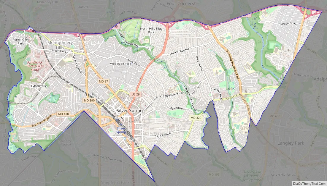
Silver Spring Road Map
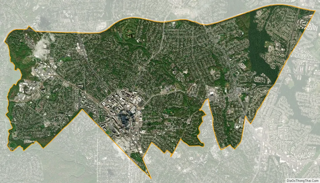
Silver Spring city Satellite Map
Geography
As an unincorporated CDP, Silver Spring’s boundaries are not consistently defined. As of the 2010 Census, the U.S. Census Bureau gives Silver Spring a total area of 7.92 square miles (20.5 km), which is all land; however, the CDP contains some creeks and small ponds. This definition is a 15% reduction from the 9.4 square miles (24 km) used in previous years.
The official Silver Spring CDP contains the following neighborhoods: Downtown Silver Spring, East Silver Spring, Woodside, Woodside Park, Lyttonsville, North Hills Sligo Park, Long Branch, Indian Spring, Goodacre Knolls, Franklin Knolls, Montgomery Knolls, Clifton Park Village, New Hampshire Estates, and Oakview.
Other organizations, such as the U.S. Geological Survey, U.S. Postal Service, Silver Spring Urban Planning District, and Greater Silver Spring Chamber of Commerce, each use their own slightly different definitions. The Postal Service in particular assigns Silver Spring mailing addresses to a large swath of eastern Montgomery County sometimes called “Greater Silver Spring,” including Four Corners, Woodmoor, Wheaton, Glenmont, Forest Glen, Forest Glen Park, Aspen Hill, Hillandale, White Oak, Colesville, Colesville Park, Cloverly, Calverton, Briggs Chaney, Greencastle, Northwood Park, Ashton, Sandy Spring, Sunset Terrace, Fairland, Lyttonsville, Kemp Mill, a portion of Langley Park, and a portion of Adelphi. The area that has a Silver Spring mailing address is larger in area than any city in Maryland except Baltimore.
Landmarks in the downtown area include the AFI Silver Theatre, the National Museum of Health and Medicine, a branch of The Fillmore, and the headquarters of the National Oceanic and Atmospheric Administration. Greater Silver Spring includes the headquarters of the Seventh-day Adventist Church, the Food and Drug Administration, and the Ahmadiyya Muslim Community in the U.S.
Parks and recreation
Four major creeks run through Silver Spring: from west to east, they are Rock Creek, Sligo Creek, Long Branch, and Northwest Branch. Each is surrounded by parks offering hiking trails, playgrounds, picnic areas, and tennis courts. On weekends, roads are closed in the parks for bicycling and walking.
Northwest Branch Park also includes the Rachel Carson Greenway Trail, named after Rachel Carson, the author of Silent Spring and a former resident of the area. It continues north to Wheaton Regional Park, in Greater Silver Spring, which is home to the 50-acre (20 ha) Brookside Gardens.
The 14.5-acre (5.9 ha) Jessup Blair Park, south of downtown, has a soccer field, tennis courts, basketball courts, and a picnic area. There are similar local parks throughout the residential parts of the community.
See also
Map of Maryland State and its subdivision: Map of other states:- Alabama
- Alaska
- Arizona
- Arkansas
- California
- Colorado
- Connecticut
- Delaware
- District of Columbia
- Florida
- Georgia
- Hawaii
- Idaho
- Illinois
- Indiana
- Iowa
- Kansas
- Kentucky
- Louisiana
- Maine
- Maryland
- Massachusetts
- Michigan
- Minnesota
- Mississippi
- Missouri
- Montana
- Nebraska
- Nevada
- New Hampshire
- New Jersey
- New Mexico
- New York
- North Carolina
- North Dakota
- Ohio
- Oklahoma
- Oregon
- Pennsylvania
- Rhode Island
- South Carolina
- South Dakota
- Tennessee
- Texas
- Utah
- Vermont
- Virginia
- Washington
- West Virginia
- Wisconsin
- Wyoming


