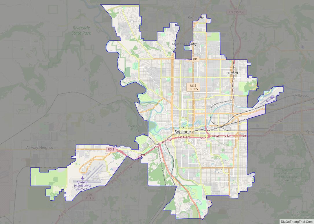
Map of Boise City city

Map of Boise City, Idaho

Boise City overview: Name: Boise City LSAD Code: 25 LSAD Description: city (suffix) State: Idaho County: Ada County FIPS code: 1608830 Discover the city of Boise, Idaho with our comprehensive map collection. We offer a range of maps that feature the city’s highway/road map, things to do, and a reference map of Boise. Our interactive … Read more

Map of Garland city, Texas

Map of Garland city, Texas

Garland is a city in the U.S. state of Texas. It is located northeast of Dallas and is a part of the Dallas–Fort Worth metroplex. It is located within Dallas County except for small portions located in Collin and Rockwall Counties. At the 2010 census, the city had a population of 226,876. In 2019, the … Read more

Map of Fremont city

Map of Fremont city, California

Fremont city overview: Name: Fremont city LSAD Code: 25 LSAD Description: city (suffix) State: California County: Alameda County Incorporated: January 23, 1956 Elevation: 56 ft (17 m) Total Area: 88.46 sq mi (229.10 km²) Land Area: 78.31 sq mi (202.83 km²) Water Area: 10.14 sq mi (26.27 km²)  11.6% Total Population: 230,504 Population Density: 2,600/sq mi (1,000/km²) ZIP code: 94536–94539, 94555 Area code: 510, 341 FIPS code: … Read more

Map of San Bernardino city

Map of San Bernardino city

San Bernardino (/ˌsæn ˌbɜːrnəˈdiːnoʊ/; Spanish for “Saint Bernardino”) is a city and county seat of San Bernardino County, California, United States. Located in the Inland Empire region of Southern California, the city had a population of 222,101 in the 2020 census, making it the 18th-largest city in California. San Bernardino is the economic, cultural, and … Read more

Map of Santa Clarita city

Map of Santa Clarita city

Santa Clarita (/ˌsæntə kləˈriːtə/; Spanish for “Little St. Clare”) is a city in northwestern Los Angeles County in the U.S. state of California. With a 2020 census population of 228,673, it is the third-largest city by population in Los Angeles County, the 17th-largest in California, and the 99th-largest city in the United States. It is … Read more

Map of Tacoma city

Map of Tacoma city

Tacoma (/təˈkoʊmə/ tə-KOH-mə) is the county seat of Pierce County, Washington, United States. A port city, it is situated along Washington’s Puget Sound, 32 miles (51 km) southwest of Seattle, 31 miles (50 km) northeast of the state capital, Olympia, and 58 miles (93 km) northwest of Mount Rainier National Park. The city’s population was 219,346 at the … Read more

Map of Hialeah city

Map of Hialeah city

Hialeah (/ˌhaɪəˈliːə/ HY-ə-LEE-ə; American Spanish: [xaʝaˈli.a]) is a city in Miami-Dade County, Florida, United States. With a population of 223,109 as of the 2020 census, Hialeah is the sixth-largest city in Florida. It is the second largest city by population in the Miami metropolitan area, which was home to an estimated 6,198,782 people at the 2018 … Read more

Map of Baton Rouge city

Map of Baton Rouge city

Baton Rouge (/ˌbætən ˈruːʒ/ BAT-ən ROOZH; from French Bâton-Rouge ‘red stick’) is a city in and the capital of the U.S. state of Louisiana. Located on the eastern bank of the Mississippi River, it is the parish seat of East Baton Rouge Parish, Louisiana’s most populous parish—the equivalent of counties in other states. Since 2020, it … Read more

Map of Huntsville city

Map of Huntsville city, Alabama

Huntsville is a city in Madison County and Limestone County, Alabama, United States, with a small portion extending into Morgan County. It is the county seat of Madison County. Located in the Appalachian region of northern Alabama, Huntsville is the most populous city in the state. Huntsville was founded within the Mississippi Territory in 1805 … Read more

Map of Port St. Lucie city

Map of Port St. Lucie city

Port St. Lucie is a city in St. Lucie County, Florida, United States. It is the most populous municipality in the county and the seventh-largest city in Florida with a population of 204,851 at the 2020 census. It is located 125 miles (201 km) southeast of Orlando and 113 miles (182 km) north of Miami. It is … Read more

Map of Modesto city

Map of Modesto city, California

Modesto (Spanish pronunciation: [moˈdesto]) is the county seat and largest city of Stanislaus County, California, United States. With a population of 218,464 at the 2020 census, it is the 19th largest city in the state of California. Modesto is located in the Central Valley, 68 miles (109 km) south of Sacramento and 90 miles (140 km) north of … Read more

Map of Fontana city

Map of Fontana city, California

Fontana is a city in San Bernardino County, California, United States. Founded by Azariel Blanchard Miller in 1913, it remained essentially rural until World War II, when entrepreneur Henry J. Kaiser built a large steel mill in the area. It is now a regional hub of the trucking industry, with the east–west Interstate 10 and … Read more