Map of Iraq

Map of Iraq

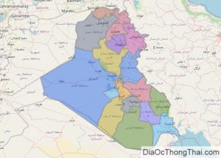
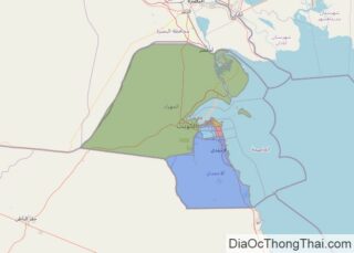
With an area of 437,072 sq. km, Iraq is the 58th largest country in the world.  The country exhibits four major physiographic regions as mentioned below. The alluvial plains cover about one-third of the country’s area in the central and southeastern parts. The elevation of land here is generally below 300 feet (100 m). As … Read more

Map of Peru

Map of Peru

Covering an area of 1,285,216 sq.km (496,225 sq mi), Peru, located in Western South America, is the world’s 19th largest country and South America’s 3rd largest country. As observed on the physical map of Peru above, the rugged Andes Mountains cover almost 40% of Peru. Hundreds of snow-capped peaks jut skyward here, with many exceeding 20,000 ft. … Read more

Map of Greece

Map of Greece

Occupying the southern most part of the Balkan Peninsula, Greece and its many islands (almost 1,500) extend southward from the European continent into the Aegean, Cretan, Ionian, Mediterranean and Thracian seas. Crete and Evia are its two largest islands and major island groups include the Argo-Saronic, Cyclades, Dodecanese, Ionian, Northeast Aegean and Sporades. With the vast percentage of its land comprised of hills and rugged mountains, Greece is … Read more

Map of New Zealand

Map of New Zealand

Covering a total area of 268,021 sq.km (103,483 sq mi), New Zealand is comprised of two large islands that can be observed on the physical map of the country above – the North Island and South Island (which are separated by the Cook Strait), as well as Stewart Island, hundreds of coastal islands and about 600 small … Read more

Map of Qatar

Map of Qatar

As observed on the physical map of Qatar, the country occupies a peninsula extending into the Persian Gulf from the Arabian Peninsula. The country also has several low lying offshore islands. Qatar occupies a total area of 11,437 sq. km.  The highly flat nature of Qatar’s terrain is easily visible on the map. The highest point in … Read more

Map of Kazakhstan

Map of Kazakhstan

Kazakhstan is a country that stretches from Central Asia to Eastern Europe and occupies an area of 2,724,900 sq. km.  As seen on the physical map of Kazakhstan above, the country extends from the Caspian Sea in the west to the Altay Mountains in the east. A vast stretch of land accounting for nearly one-third … Read more

Map of Algeria

Map of Algeria

The map illustrates Algeria’s landscape which consists mostly of high plateaus and the Sahara Desert. The Atlas mountains sit to the north, and the Ahaggar Massif is southeast. The high plateaus stretch for more than 372 miles (600 km) and consist of undulating, steppe-like plains averaging 3,608 – 4,265 ft (1,100 – 1,300 m) and … Read more

Map of Hungary

Map of Hungary

Hungary is a medium-sized, landlocked Central European country covering an area of 93,030 km2(35,920 sq mi). As observed on the physical map of Hungary, it is mostly a flat country, dominated by the Great Hungarian Plain east of the Danube. The plain includes approximately 56% of the country’s land. The terrain ranges from flat to … Read more

Map of Ukraine

Map of Ukraine

Ukraine is the largest country that is entirely within Europe. The country sits on the southwestern part of the Russian Plain and is bordered by the Black Sea and the Sea of Azov to the south, Russia to the east and north, Belarus to the north, Poland, Slovakia, and Hungary to the west, and Romania … Read more

Map of Kuwait

Map of Kuwait

Kuwait occupies an area of 17,818 sq. km on the Arabian Peninsula at the head of the Persian Gulf. As observed on the physical map of Kuwait above, the country also has several islands like Warbah, Bubiyan, and Failakah Islands. Marked on the map is the Kuwait Bay which a major geographic feature in the … Read more

Map of Morocco

Map of Morocco

Morocco is a country in the Maghreb Region of North Africa where it covers an area of 710,850 sq. km.  Much of Morocco’s landscape is mountainous with slopes that gradually transition into plateaus and valleys. As observed on the physical map above, the Atlas mountains dominate the central part of the country, while the Rif … Read more

Map of Ecuador

Map of Ecuador

Covering an area of 283,561 sq.km (109,484 sq mi), Ecuador is a country located in northwestern South America. Ecuador is divided into four geographic regions: the coastal lowlands and mountain area; the Central Andes Mountains and its two major chains (Cordillera Occidental in the West) and the (Cordillera Oriental in the east); the lower mountains that fade … Read more