The City and Borough of Juneau, more commonly known simply as Juneau (/ˈdʒuːnoʊ/ JOO-noh; Tlingit: Dzánti K’ihéeni [ˈtsʌ́ntʰɪ̀ kʼɪ̀ˈhíːnɪ̀]), is the capital city of the U.S. state of Alaska. Located in the Gastineau Channel and the Alaskan panhandle, it is a unified municipality and the second-largest city in the United States by area. Juneau was named the capital of Alaska in 1906, when the government of what was then the District of Alaska was moved from Sitka as dictated by the U.S. Congress in 1900. The municipality unified on July 1, 1970, when the city of Juneau merged with the city of Douglas and the surrounding Greater Juneau Borough to form the current municipality, which is larger by area than both Rhode Island and Delaware.
Downtown Juneau is nestled at the base of Mount Juneau and across the channel from Douglas Island. As of the 2020 census, the City and Borough had a population of 32,255, making it the third-most populous city in Alaska after Anchorage and Fairbanks. Juneau experiences a daily influx of roughly 6,000 people from visiting cruise ships between the months of May and September.
The city is named after a gold prospector from Quebec, Joe Juneau, though the place was once called Rockwell and then Harrisburg (after Juneau’s co-prospector, Richard Harris). The Tlingit name of the town is Dzántik’i Héeni (“Base of the Flounder’s River,” dzánti ‘flounder,’ –kʼi ‘base,’ héen ‘river’), and Auke Bay just north of Juneau proper is called Áak’w (“Little lake,” áa ‘lake,’ -kʼ ‘diminutive’) in Tlingit. The Taku River, just south of Juneau, was named after the cold t’aakh wind, which occasionally blows down from the mountains.
Juneau is unique among the 49 U.S. capitals on mainland North America in that there are no roads connecting the city to the rest of the state or North America. Honolulu, Hawaii, is the only other state capital not connected by road to the rest of North America. The absence of a road network is due to the extremely rugged terrain surrounding the city. This in turn makes Juneau a de facto island city in terms of transportation, since all goods coming in and out must go by plane or boat, in spite of the city’s location on the Alaskan mainland. Downtown Juneau sits at sea level, with tides averaging 16 feet (5 m), below steep mountains about 3,500 to 4,000 feet (1,100 to 1,200 m) high. Atop these mountains is the Juneau Icefield, a large ice mass from which about 30 glaciers flow; two of these, the Mendenhall Glacier and the Lemon Creek Glacier, are visible from the local road system. The Mendenhall glacier has been gradually retreating; its front face is declining in width and height.
The Alaska State Capitol in downtown Juneau was built as the Federal and Territorial Building in 1931. Prior to statehood, it housed federal government offices, the federal courthouse and a post office. It also housed the territorial legislature and many other territorial offices, including that of the governor. Today, Juneau remains the home of the state legislature and the offices of the governor and lieutenant governor. Some other executive branch offices have moved elsewhere in the state.
| Name: | Juneau City and Borough |
|---|---|
| FIPS code: | 02-110 |
| State: | Alaska |
| Named for: | Joe Juneau |
| Land Area: | 2,704.03 sq mi (7,003.41 km²) |
| Population Density: | 11.93/sq mi (4.61/km²) |
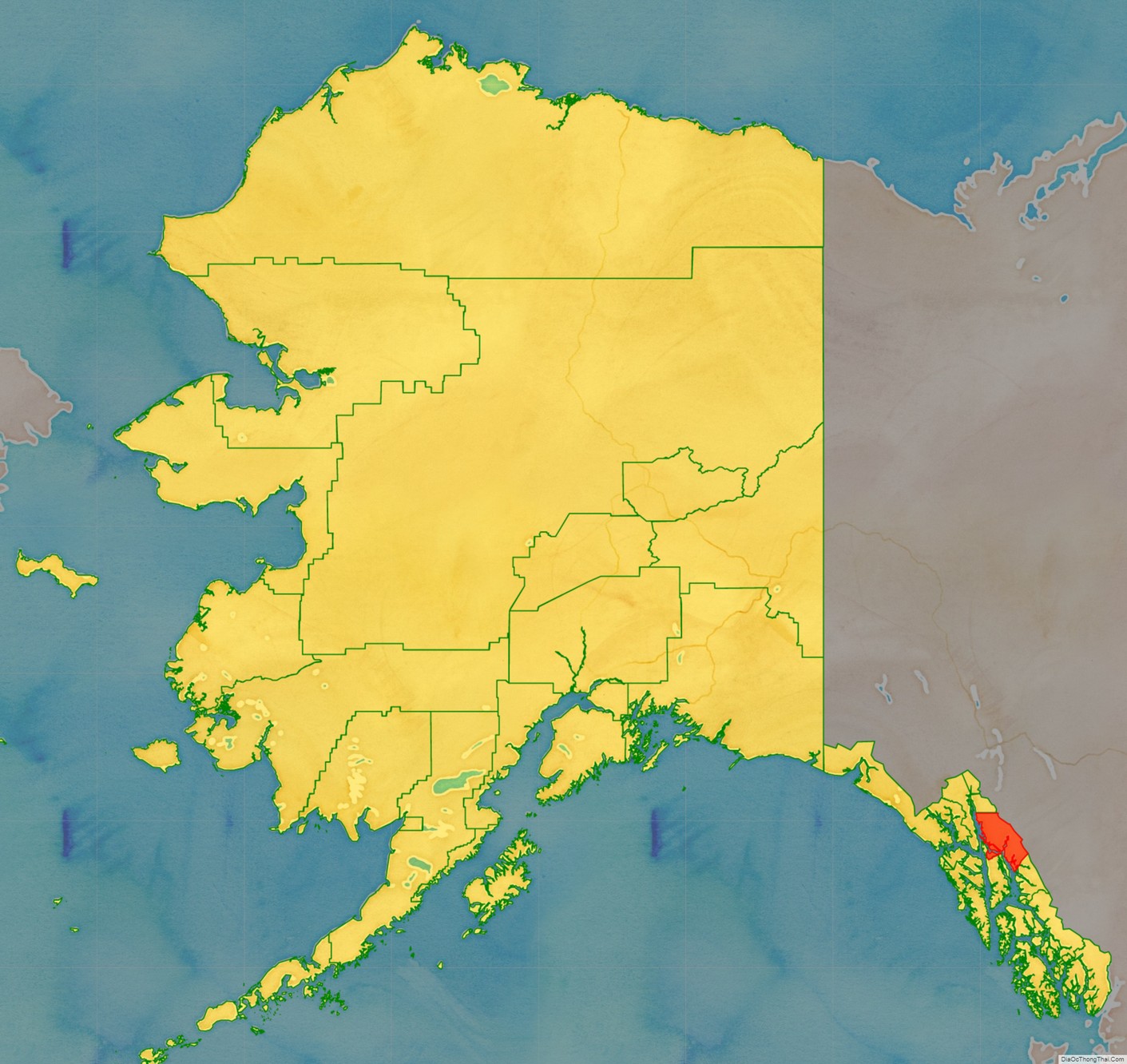
Juneau City and Borough location map. Where is Juneau City and Borough?
History
The Gastineau Channel was a fishing ground for the Auke (A’akw Kwáan) and Taku tribes, who had inhabited the surrounding area for thousands of years. The A’akw Kwáan had a village and burying ground here. In the 21st century it is known as Indian Point. They annually harvested herring during the spawning season.
Since the late 20th century, the A’akw Kwáan, together with the Sealaska Heritage Institute, have resisted European-American development of Indian Point, including proposals by the National Park Service and the National Oceanic and Atmospheric Administration (NOAA). They consider it sacred territory, both because of the burying ground and the importance of the point in their traditions of gathering sustenance from the sea. They continue to gather clams, gumboot chitons, grass and sea urchins there, as well as tree bark for medicinal uses. The city and state supported Sealaska Heritage Institute in documenting the 78 acres (32 ha) site, and, in August 2016, it was listed on the National Register of Historic Places. “It is the first traditional cultural property in Southeast Alaska to be placed on the register.”
Descendants of these indigenous cultures include the Tlingit people. Native cultures have rich artistic traditions expressed in carving, weaving, orating, singing, and dancing. Juneau has become a major social center for the Tlingit, Haida, and Tsimshian of Southeast Alaska.
European encounters
Although the Russians had a colony in the Alaska territory from 1784 to 1867, they did not settle in Juneau. They conducted extensive fur trading with Alaskan Natives of the Aleutian Islands and Kodiak.
The first European to see the Juneau area was Joseph Whidbey, master of the Discovery during George Vancouver’s 1791–95 expedition. He and his party explored the region in July–August 1794. Early in August he viewed the length of Gastineau Channel from the south, noting a small island in mid-channel. He later recorded seeing the channel again, this time from the west. He said it was unnavigable, being filled with ice.
Mining era
After the California gold rush, miners migrated up the Pacific Coast and explored the West, seeking other gold deposits. In 1880, Sitka mining engineer George Pilz offered a reward to any local native in Alaska who could lead him to gold-bearing ore. A local native arrived with some ore, and several prospectors were sent to investigate. On their first trip to Gold Creek, they found deposits of little interest. However, Pilz sent Joe Juneau (cousin of Milwaukee co-founder Solomon Juneau) and Richard Harris back to the Gastineau Channel, directing them to Snow Slide Gulch (the head of Gold Creek). According to the Rev. Samuel Young, in his book Alaska Days with John Muir, it was their party’s campsite at the creek head that Juneau and Harris decided to explore, in the summer of 1879. There they found nuggets “as large as peas and beans,” in Harris’ words.
On October 18, 1880, the two men marked a 160-acre (650,000 m) town site where soon a mining camp sprang up. Within a year, so many miners had arrived that the camp became a village, albeit made up mostly of tents and shacks rather than substantial buildings. It was the first European American settlement founded in this territory after the United States purchased Alaska.
By the autumn of 1881, the village had a population of over 100 and was known as Rockwell, after Lt. Com. Charles Rockwell; later it was known as Harrisburg after prospector Richard Harris. On December 14, 1881, a miners’ meeting of 72 persons decided to name the settlement Juneau, after prospector Joe Juneau.
Establishment of Russian Orthodox Church
Perhaps because of the pressure of this European encroachment, some Tlingit appealed to the Russian Orthodox Church. It had given services in northern Tlingit settlements in local languages since 1800 and 1824. One of its priests had translated scripture and liturgy into the Tlingit language in the 1830s–1840s. The Tlingit arranged for an Orthodox priest to come to their settlement in Juneau. In 1890, some 700 people converted, following chief Yees Gaanaalx and his wife of Auke Bay. The Orthodox Church Missionary Society supported the Tlingit in furnishing and constructing a church for this large congregation.
St. Nicholas Orthodox Church was completed in 1894 and has maintained a strong presence among the Tlingit, Serbians, and other Europeans who followed this church. The iconostasis has six large panels sent from Russia.
Development of mining
During this period, prospector and placer miner John Lemon operated in what is today the Lemon Creek area. The neighborhood that developed there was named for him by early settlers, as have been several other landmarks in Juneau.
Major mining operations in the Juneau mining district prior to World War II included the Treadwell Mine, The Alaska-Juneau Mine, and Alaska-Gastineau Mine.
By 1906, after the decline of whaling and the fur trade, Sitka, the original capital of Alaska, had become less important and the territorial legislature moved the seat of government to Juneau in accordance with a 1900 federal law. Juneau was the largest city in Alaska during the inter-war years, passing Fairbanks in the 1920 census. In the post-World War II years, it was displaced by Anchorage in 1950.
20th and 21st centuries
In 1911, the United States Congress authorized funds for construction of a capitol building for the Alaska Territory. World War I delayed construction and there were difficulties purchasing the necessary land. Citizens of Juneau donated some of the required funds, and construction began on September 8, 1929. Construction of the capitol took less than two years, and the building was dedicated as the Federal and Territorial Building on February 14, 1931. It was designed by Treasury Department architects in the Art Deco architectural style. The building was originally used by the federal government to house the federal courthouse and post office for the territory. Since Alaska gained statehood in 1959, the building has been used by the state government.
The Alaska Governor’s Mansion was commissioned under the Public Building Act in 1910. The mansion was designed by James Knox Taylor in the Federal style. Construction was completed in 1912. The territorial governor at that time was the first governor to inhabit the mansion, and he held the first open house for citizens on January 1, 1913. The area of the mansion is 14,400 square feet (1,340 m). It has ten bathrooms, six bedrooms, and eight fireplaces. The governor resides here when in Juneau on official business. In June 1923, President Warren G. Harding became the first president to visit Alaska. Harding visited the Governor’s Mansion while Territorial Governor Scott Bone, who was appointed by Harding, was in office. Harding spoke from the porch of the mansion explaining his policies and met with attendees.
During World War II, more than 50 Japanese citizens and Japanese Americans residing in Juneau were evacuated to the internment camps inland as a result of Executive Order 9066—which authorized the forced removal of all ethnic Japanese away from their homes and businesses on the West Coast of the United States. The removal of Juneau’s Japanese community during the war was later commemorated known as the Empty Chair Memorial in July 2014 during a dedication ceremony at the neighborhood of Capital School Park in the city.
Robert Atwood, then publisher of the Anchorage Times and an Anchorage “booster,” was an early leader in efforts to move the capital to Fairbanks, which many in both cities resisted. Some supporters of a move wanted a new capital to be at least 30 miles (48 km) from Anchorage and Fairbanks, to prevent either city from having undue influence. Juneau has continued as the capital. In the 1970s, voters passed a plan to move the capital to Willow, a town 70 miles (110 km) north of Anchorage. But pro-Juneau people there and in Fairbanks persuaded voters also to approve a measure (the FRANK Initiative) requiring voter approval of all bondable construction costs before building could begin. Alaskans later voted against spending the estimated $900 million. A 1984 “ultimate” capital-move vote also failed, as did a 1996 vote.
Juneau remains the capital. Once Alaska was granted statehood in 1959, Juneau’s population increased along with the growth of state government. After construction of the Alaska Pipeline in 1977, the state budget was flush with oil revenues, and it expanded programs for the people. That growth slowed considerably in the 1980s.
In 2005, the state demographer projected slow growth in the borough for the next twenty years. Cruise ship tourism has expanded rapidly, from approximately 230,000 passengers in 1990 to nearly 1,000,000 in 2006, as cruise lines have built more and larger ships. They sail to Juneau seven days a week over a longer season than before, but the cruising tourism is still primarily a summer industry. It provides few year-round jobs but stimulates summer employment in the city.
In 2010, the city was recognized as part of the “Playful City USA” initiative by KaBOOM!, created to honor cities that ensure their children have great places to play.
Juneau is larger in area than the state of Delaware and was, for several decades, the country’s largest city by area. (Sitka surpassed it in 2000 when it incorporated.) Juneau continues to be the only U.S. state capital on an international border: it is bordered on the east by Canada. It is the U.S. state capital whose namesake was most recently alive: Joe Juneau died in 1899.
The city was temporarily renamed UNO, after the card game, on April 1, 2016 (April Fool’s Day). The change was part of a promotion with Mattel to draw “attention to new wild cards in [the] game”. For Juneau’s cooperation, Mattel donated $15,000 “to the Juneau Community Foundation in honor of late Mayor Greg Fisk.”
Juneau City and Borough Road Map
Geography
According to the United States Census Bureau, the borough has an area of 3,255 square miles (8,430 km). It is the second-largest city in the United States by area, with 2,716.7 square miles (7,036 km) being made up of land and 538.3 square miles (1,394 km) consisting of water (16.54%).
Central (downtown) Juneau is at 58°18′00″N 134°24′58″W / 58.30000°N 134.41611°W / 58.30000; -134.41611. The City and Borough of Juneau includes Douglas Island, a tidal island to the west of mainland Juneau. Douglas Island can be reached via the Juneau-Douglas Bridge.
As is the case throughout Southeast Alaska, the Juneau area is susceptible to damage caused by natural disasters. The 2014 Palma Bay earthquake caused widespread outages to telecommunications in the area due to damage to a fiber optic cable serving the area. In April 2008, a series of massive avalanches outside Juneau heavily damaged the electrical lines providing Juneau with power, knocking the hydroelectric system offline and forcing the utility to switch to a much more expensive diesel system.
Adjacent boroughs and census areas
- Haines Borough, Alaska – northwest, west
- Hoonah-Angoon Census Area, Alaska – south, southwest
- Petersburg Borough, Alaska – quadripoint
Border area
Juneau, Alaska, shares its eastern border with the Canadian province of British Columbia. It is the only U.S. state capital to border another country.
- Stikine Region, British Columbia – northeast, east
National protected areas
- Tongass National Forest (part)
- Admiralty Island National Monument (part)
- Kootznoowoo Wilderness (part)
- Tracy Arm-Fords Terror Wilderness (part)
- Admiralty Island National Monument (part)
State Parks
Alaska State Parks maintains the Juneau Trail System, a series of wilderness trails ranging from easy to extremely difficult.
Climate
The Juneau area is in a transition zone between a humid continental climate (Köppen Dfb), a subarctic climate (Köppen Dfc), and an oceanic climate (Köppen Cfb/Cfc), depending on the isotherm used. The city’s climate is heavily influenced by the proximity of the Pacific Ocean, specifically the warm Alaska Current, and the Coast Mountains that form a natural orographic barrier for incoming air. The weather is thus mild and moist, which, as in other parts of the Alaska Panhandle, allows the growth of temperate rainforests. Like other settlements in the area, Juneau does not experience permafrost.
There are two prevalent types of wind in Juneau. Particularly in winter, the Aleutian Low will draw warm and moist air from the south, bringing ample snow- or rainfall, and even in summer, winds will tend to blow onshore. The strength and frequency of the rainfall will depend from several factors, including the presence of El Niño (more mild and rainy weather) or La Niña (colder and drier periods due to the presence of an anticyclone in the Gulf of Alaska). Conversely, offshore winds from the interior are normally dry but may have extreme variations in temperature.
Temperatures vary relatively little over the year. Winters are mild by Alaskan standards, with the average temperature of January slightly below freezing and highs often above 32 °F (0.0 °C); summers are rather cool but occasionally may get warm. Temperatures above 75 °F (23.9 °C) or below 10 °F (−12.2 °C) are not unheard of but are rare. Precipitation falls on an average 230 days per year, averaging 62.27 inches (1,580 mm) at the airport (1981–2010 normals), but ranging from 55 to 92 inches (1,400 to 2,340 mm), depending on location. Most of it will occur in fall and winter, some falling as snow from November to March.
Records have been officially kept at downtown Juneau from January 1890 to June 1943, and at Juneau International Airport since July 1943. The coldest temperature ever officially recorded in Juneau was −22 °F (−30.0 °C) on February 2, 1968, and January 12, 1972, while the hottest was 90 °F (32.2 °C) on July 7, 1975. The normals and record temperatures for both downtown and the airport are given below.
