Akutan (/ˈækuːtæn/ AK-oo-tan, Aleut: Achan-ingiiga) is a city on Akutan Island in the Aleutians East Borough of the Aleutian Islands in Alaska, United States. The population was 1,589 at the 2020 census, up from 1,027 in 2010, making it the 4th fastest-growing city of the decade in Alaska. Akutan Harbor is adjacent.
| Name: | Akutan city |
|---|---|
| LSAD Code: | 25 |
| LSAD Description: | city (suffix) |
| State: | Alaska |
| County: | Aleutians East Borough |
| Incorporated: | 1979 |
| Elevation: | 98 ft (30 m) |
| Total Area: | 147.90 sq mi (383.07 km²) |
| Land Area: | 65.98 sq mi (170.88 km²) |
| Water Area: | 81.93 sq mi (212.19 km²) |
| Total Population: | 1,589 |
| Population Density: | 24.08/sq mi (9.30/km²) |
| ZIP code: | 99553 |
| Area code: | 907 |
| FIPS code: | 0201090 |
| GNISfeature ID: | 1418123 |
Online Interactive Map
Click on ![]() to view map in "full screen" mode.
to view map in "full screen" mode.
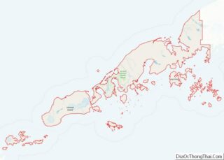
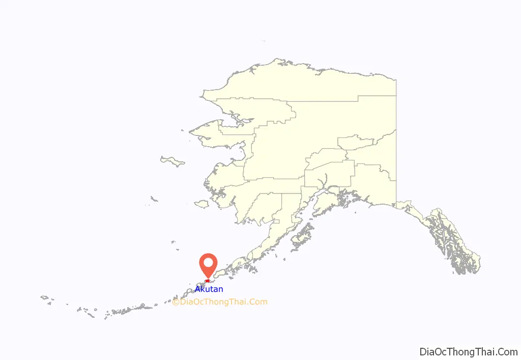
Akutan location map. Where is Akutan city?
History
Akutan began in 1878 as a fur storage and trading port for the Western Fur & Trading Company. The company’s agent established a commercial cod fishing and processing business that quickly attracted nearby Unangan to the community. A Russian Orthodox church and a school were built in 1878, but was replaced by the St. Alexander Nevsky Chapel, built in 1918.
The Pacific Whaling Company built a whale processing station across the bay from Akutan in 1912. It was the only whaling station in the Aleutians, and operated until 1939.
After the Japanese attacked Unalaska in June 1942, the U.S. government evacuated Akutan residents to the Ketchikan area. In June 1942, a Japanese A6M Zero fighter piloted by Tadayoshi Koga crashed on Akutan Island. It was recovered in July by the United States Army Air Force. This plane, dubbed the Akutan Zero, significantly aided American tacticians in devising dog fighting techniques to defeat the Zero, and helped change the course of the war.
The village was re-established in 1944, although many villagers chose not to return. This exposure to the outside world brought many changes to the traditional lifestyle and attitudes of the community. The city was incorporated in 1979.
A federally recognized tribe is located in the community—the Native Village of Akutan. The population of the community consists of 16.4% Alaska Native or part Native. Akutan is a fishing community, and is the site of a traditional Unangan village. Approximately 75 persons are year-round residents; the majority of the population are transient fish processing workers that live in group quarters.
Whaling station along the harbor at Akutan ca. 1915
Whaler Unimak in Akutan Harbor, 1914. An American Pacific Sea Products Co. vessel
Men standing by dead whale at Akutan Harbor whaling station, 1914
Flensing whales at Akutan, ca. 1915
Akutan Road Map

Akutan city Satellite Map

Geography
Akutan is located at 54°7′57″N 165°46′30″W / 54.13250°N 165.77500°W / 54.13250; -165.77500. Akutan is located in the Aleutian Islands Recording District.
Akutan is located on Akutan Island in the eastern Aleutians, one of the Krenitzin Islands in the Fox Islands group. It is 35 miles (56 km) east of Unalaska, and 766 miles (1,233 km) southwest of Anchorage. Akutan lies in the maritime climate zone, resulting in mild winters and cool summers. Mean temperatures range from 22 to 55 °F (−6 to 13 °C), and precipitation averages 28 inches (710 mm) per year. High winds and storms are frequent in the winter, and fog is common in the summer.
According to the U.S. Census Bureau, the city has a total area of 18.9 square miles (49 km), of which, 14.0 square miles (36 km) of it is land and 4.9 square miles (13 km) of it (25.69%) is water.
See also
Map of Alaska State and its subdivision:- Aleutians East
- Aleutians West
- Anchorage
- Bethel
- Bristol Bay
- Denali
- Dillingham
- Fairbanks North Star
- Haines
- Juneau
- Kenai Peninsula
- Ketchikan Gateway
- Kodiak Island
- Lake and Peninsula
- Matanuska-Susitna
- Nome
- North Slope
- Northwest Arctic
- Prince of Wales-Outer Ketchi
- Sitka
- Skagway-Yakutat-Angoon
- Southeast Fairbanks
- Valdez-Cordova
- Wade Hampton
- Wrangell-Petersburg
- Yukon-Koyukuk
- Alabama
- Alaska
- Arizona
- Arkansas
- California
- Colorado
- Connecticut
- Delaware
- District of Columbia
- Florida
- Georgia
- Hawaii
- Idaho
- Illinois
- Indiana
- Iowa
- Kansas
- Kentucky
- Louisiana
- Maine
- Maryland
- Massachusetts
- Michigan
- Minnesota
- Mississippi
- Missouri
- Montana
- Nebraska
- Nevada
- New Hampshire
- New Jersey
- New Mexico
- New York
- North Carolina
- North Dakota
- Ohio
- Oklahoma
- Oregon
- Pennsylvania
- Rhode Island
- South Carolina
- South Dakota
- Tennessee
- Texas
- Utah
- Vermont
- Virginia
- Washington
- West Virginia
- Wisconsin
- Wyoming