Map of Chicago city

Map of Chicago city

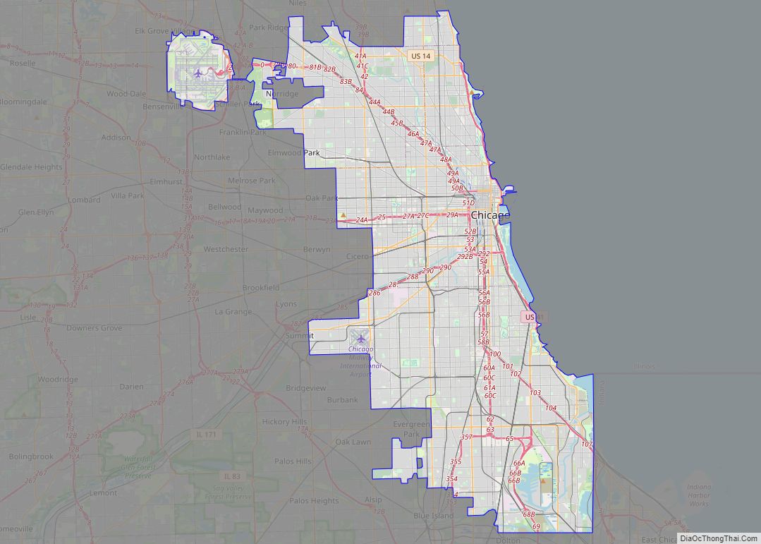
Chicago city overview: Name: Chicago city LSAD Code: 25 LSAD Description: city (suffix) State: Illinois County: Cook County, DuPage County Land Area: 227.73 sq mi (589.82 km²) Water Area: 6.80 sq mi (17.62 km²) Population Density: 12,059.84/sq mi (4,656.33/km²) FIPS code: 1714000 GNISfeature ID: 0428803 Website: chicago.gov Your Ultimate Chicago Map Collection: 1. Road Map of Chicago – Get around the city … Read more

Map of Joliet city

Map of Joliet city, Illinois

Joliet (/ˈdʒoʊliɛt, dʒoʊliˈɛt/ JOH-lee-et, joh-lee-ET) is a city in Will and Kendall counties in the U.S. state of Illinois, 35 miles (56 km) southwest of Chicago. It is the county seat of Will County. At the 2020 census, the city was the third-largest in Illinois, with a population of 150,362. Joliet city overview: Name: Joliet city … Read more

Map of Naperville city

Map of Naperville city

Naperville (/ˈneɪpərˌvɪl/ NAY-pər-vil) is a city within the Chicago Metropolitan Area in DuPage and Will counties in the U.S. state of Illinois. It is a western suburb of Chicago located 28 miles (45 km) west of the city. Naperville was founded in 1831 by Joseph Naper. The city was established by the banks of the DuPage … Read more

Map of Elgin city, Illinois

Map of Elgin city, Illinois

Elgin (/ˈɛldʒɪn/ EL-jin) is a city in Cook and Kane counties in the northern part of Illinois, United States. Elgin is located 35 mi (56 km) northwest of Chicago, along the Fox River. As of the 2020 Census, the city had a population of 114,797, the sixth-largest city in Illinois. Elgin city overview: Name: Elgin city LSAD … Read more

Map of Springfield city, Illinois

Map of Springfield city, Illinois

Springfield is the capital of the U.S. state of Illinois and the county seat and largest city of Sangamon County. The city’s population was 114,394 at the 2020 census, which makes it the state’s seventh most-populous city, the second largest outside of the Chicago metropolitan area (after Rockford), and the largest in central Illinois. Approximately … Read more

Map of Peoria city, Illinois

Map of Peoria city, Illinois

Peoria (/piˈɔːriə/ pee-OR-ee-ə) is a city in and county seat of Peoria County, Illinois, United States. Located on the Illinois River, the city had a population of 113,150 as of the 2020 census. It is the principal city of the Peoria Metropolitan Area in Central Illinois, consisting of the counties of Fulton, Marshall, Peoria, Stark, … Read more

Map of Albers village

Map of Albers village

Albers is a village in Clinton County, Illinois, United States. The population was 1,121 at the 2020 census. Albers village overview: Name: Albers village LSAD Code: 47 LSAD Description: village (suffix) State: Illinois County: Clinton County Elevation: 440 ft (130 m) Total Area: 0.99 sq mi (2.57 km²) Land Area: 0.99 sq mi (2.57 km²) Water Area: 0.00 sq mi (0.00 km²) Total Population: 1,121 Population … Read more

Map of Albany village, Illinois

Map of Albany village, Illinois

Albany is a village in Whiteside County, Illinois, United States. The population was 891 at the 2010 census, down from 895 in 2000. Albany village overview: Name: Albany village LSAD Code: 47 LSAD Description: village (suffix) State: Illinois County: Whiteside County Total Area: 1.07 sq mi (2.77 km²) Land Area: 1.07 sq mi (2.77 km²) Water Area: 0.00 sq mi (0.00 km²) Total Population: … Read more

Map of Adeline village

Map of Adeline village

Adeline is a village in Maryland Township, Ogle County, Illinois, United States, along the Leaf River. The population was 85 at the 2010 census, down from 139 in 2000. Adeline village overview: Name: Adeline village LSAD Code: 47 LSAD Description: village (suffix) State: Illinois County: Ogle County Elevation: 797 ft (243 m) Total Area: 0.27 sq mi (0.69 km²) Land … Read more

Map of Addison village, Illinois

Map of Addison village, Illinois

Addison is a village located in the Chicago Metropolitan Area, in DuPage County, Illinois, United States. The population was 36,942 at the 2010 census. Addison village overview: Name: Addison village LSAD Code: 47 LSAD Description: village (suffix) State: Illinois County: DuPage County Incorporated: 1884 Elevation: 702 ft (214 m) Total Area: 10.00 sq mi (25.90 km²) Land Area: 9.83 sq mi (25.46 km²) … Read more