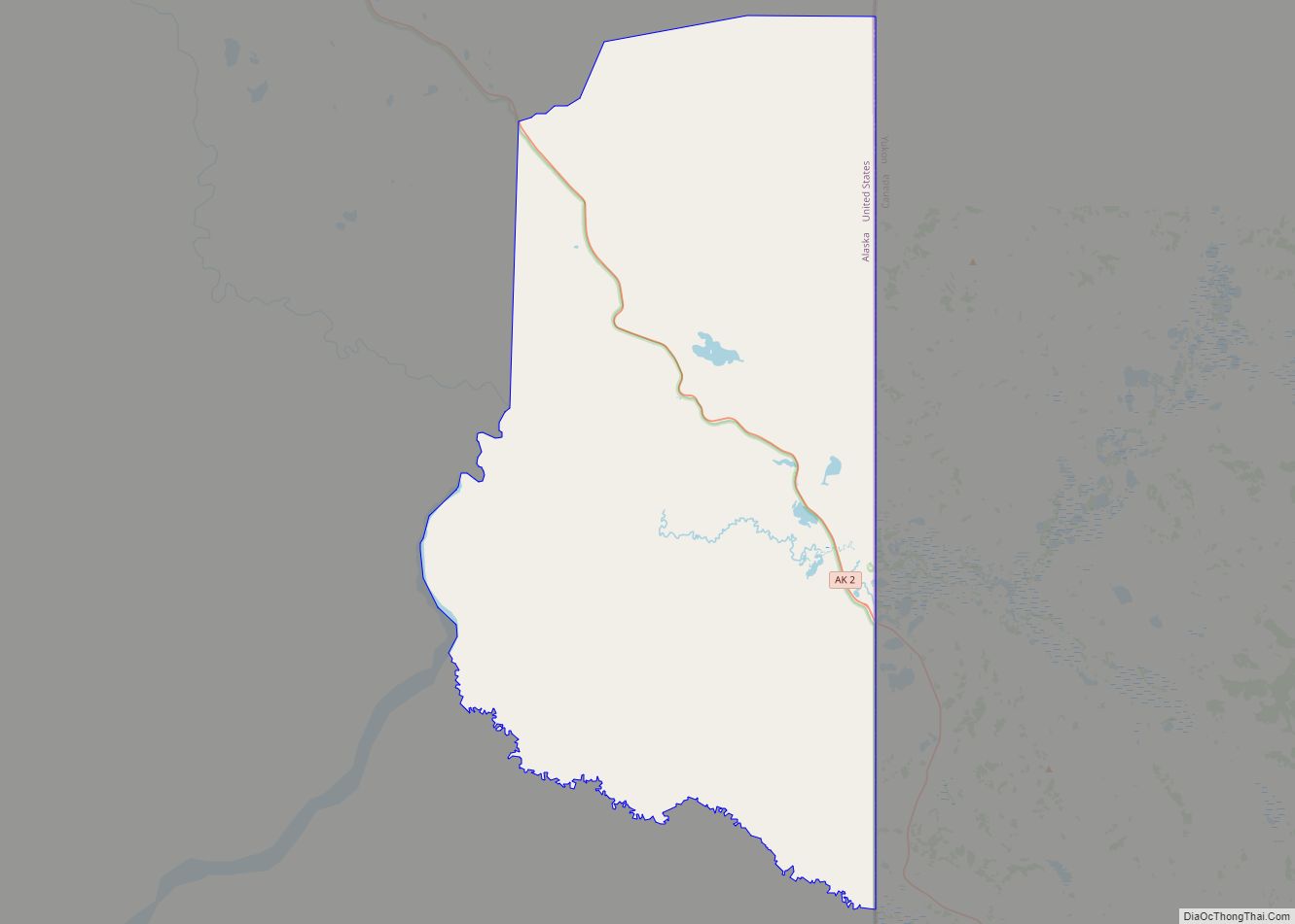
Map of Alakanuk city

Map of Alakanuk city

Alakanuk (ah-LUG-uh-nuck) (Central Yupik: Alarneq) is a second class city in the Kusilvak Census Area of the Unorganized Borough in the western part of the U.S. state of Alaska. As of the 2010 census, the population of the city was 677, up from 652 in 2000. Alakanuk city overview: Name: Alakanuk city LSAD Code: 25 … Read more

Map of Akutan city

Map of Akutan city

Akutan (/ˈækuːtæn/ AK-oo-tan, Aleut: Achan-ingiiga) is a city on Akutan Island in the Aleutians East Borough of the Aleutian Islands in Alaska, United States. The population was 1,589 at the 2020 census, up from 1,027 in 2010, making it the 4th fastest-growing city of the decade in Alaska. Akutan Harbor is adjacent. Akutan city overview: … Read more

Map of Alcan Border CDP

Map of Alcan Border CDP

Alcan Border, also known as Port Alcan, is a census-designated place in the Southeast Fairbanks Census Area in the U.S. state of Alaska. Part of the Unorganized Borough, Alcan Border is the site of the Alcan – Beaver Creek Border Crossing, the main U.S. port of entry for persons arriving in Alaska by road. The … Read more

Map of Aleneva CDP

Map of Aleneva CDP

Aleneva is a census-designated place in the Kodiak Island Borough in the U.S. state of Alaska. As of the 2010 census, the population was 37, down from 68 in 2000. Aleneva CDP overview: Name: Aleneva CDP LSAD Code: 57 LSAD Description: CDP (suffix) State: Alaska County: Kodiak Island Borough Elevation: 620 ft (189 m) Total Area: 62.21 sq mi … Read more

Map of Aleknagik city

Map of Aleknagik city

Aleknagik (/əˈlɛknəɡɪk/ ə-LEK-nə-gik; Central Yupik: Alaqnaqiq) is a second class city in the Dillingham Census Area of the Unorganized Borough of the U.S. state of Alaska. The population was 219 at the 2010 census, down from 221 in 2000. Aleknagik city overview: Name: Aleknagik city LSAD Code: 25 LSAD Description: city (suffix) State: Alaska County: … Read more

Map of Anaktuvuk Pass city

Map of Anaktuvuk Pass city

Anaktuvuk Pass (Inupiaq: Anaqtuuvak, IPA: [ɐnɑqtuːvɐk], Anaqtuġvik or Naqsraq, IPA: [naχʂɑq]) is a city in North Slope Borough, Alaska, United States. The population was 282 at the 2000 census and 324 as of the 2010 census. Anaktuvuk Pass city overview: Name: Anaktuvuk Pass city LSAD Code: 25 LSAD Description: city (suffix) State: Alaska County: North Slope Borough … Read more

Map of Ambler city

Map of Ambler city, Alaska

Ambler (Inupiaq: Ivisaappaat, IPA: [ivisaːpːaːt]) is a city in Northwest Arctic Borough, Alaska, United States. At the 2010 census the population was 258, down from 309 in 2000. The city is located in the large Iñupiaq language speaking region of Alaska, and the local dialect is known as the Ambler dialect (related to the Shugnak dialect). … Read more

Map of Allakaket city

Map of Allakaket city

Allakaket (/æləˈkækɪt/ al-ə-KAK-it) (Aalaa Kkaakk’et in Koyukon) is a second class city in the Yukon-Koyukuk Census Area of the Unorganized Borough of the U.S. state of Alaska. The population was 105 at the 2010 census. Allakaket city overview: Name: Allakaket city LSAD Code: 25 LSAD Description: city (suffix) State: Alaska County: Yukon-Koyukuk Census Area Incorporated: … Read more

Map of Angoon city

Map of Angoon city

Angoon (sometimes formerly spelled Angun, Tlingit: Aangóon) is a city on Admiralty Island in Hoonah-Angoon Census Area, Alaska, United States. At the 2000 census the population was 572; by the 2010 census the population had declined to 459. The name in Tlingit, Aangóon, means roughly “isthmus town.” Angoon city overview: Name: Angoon city LSAD Code: … Read more

Map of Anderson city

Map of Anderson city, Alaska

Anderson is a city in the Denali Borough, Alaska, United States, and the borough’s only incorporated community. At the 2010 census the population was 246, down from 367 at the 2000 census. At the 2020 census, the population dropped to 177 residents. The city is named after one of the original homesteaders. Anderson city overview: … Read more

Map of Anchor Point CDP

Map of Anchor Point CDP

Anchor Point (Dena’ina: K’kaq’) is an unincorporated community and census-designated place (CDP) in Kenai Peninsula Borough, in the U.S. state of Alaska. As of the 2010 census the population was 1,930, up from 1,845 in 2000. The community is located along the Sterling Highway, part of Alaska State Route 1. Anchor Point is the westernmost … Read more

Map of Arctic Village CDP

Map of Arctic Village CDP

Arctic Village (Vashrąįį K’ǫǫ in Gwich’in) is an unincorporated Native American village and a census-designated place (CDP) in Yukon-Koyukuk Census Area, Alaska, United States. As of the 2010 census, the population of the CDP was 152. This was unchanged from 2000. The village is located in the large Gwitch’in speaking region of Alaska, and the … Read more