Map of Vernon town, Indiana
Vernon is a town within Vernon Township and the county seat of Jennings County, Indiana, United States. With a population of 318 in the 2010 census, it is the smallest town with that designation in the state of Indiana, lying just south of the much larger North Vernon. It is also the smallest county seat ... Read more
Map of Vernon town, Indiana
Map of Vera Cruz town
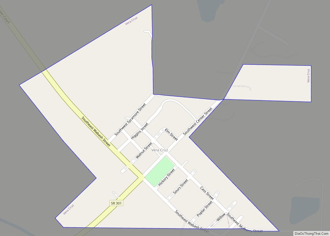
Vera Cruz is a town in Harrison Township, Wells County, in the U.S. state of Indiana. The population was 80 at the 2010 census. Vera Cruz town overview: Name: Vera Cruz town LSAD Code: 43 LSAD Description: town (suffix) State: Indiana County: Wells County Elevation: 827 ft (252 m) Total Area: 0.10 sq mi (0.26 km²) Land Area: 0.10 sq mi (0.26 km²) ... Read more
Map of Vera Cruz town
Map of Vincennes city
Vincennes is a city in and the county seat of Knox County, Indiana, United States. It is located on the lower Wabash River in the southwestern part of the state, nearly halfway between Evansville and Terre Haute. Founded in 1732 by French fur traders, notably François-Marie Bissot, Sieur de Vincennes, for whom the Fort was ... Read more
Map of Vincennes city
Map of Vevay town
Vevay (/ˈviːviː/ VEE-vee) is a town located in Jefferson Township and the county seat of Switzerland County, Indiana, United States, along the Ohio River. The population was 1,683 at the 2010 census. Vevay town overview: Name: Vevay town LSAD Code: 43 LSAD Description: town (suffix) State: Indiana County: Switzerland County Elevation: 482 ft (147 m) Total Area: ... Read more
Map of Vevay town
Map of Versailles town, Indiana
Versailles /vərˈseɪlz/ is a town in Johnson Township, Ripley County, in the U.S. state of Indiana. The population was 2,113 at the 2010 census. The town is the county seat of Ripley County. Versailles town overview: Name: Versailles town LSAD Code: 43 LSAD Description: town (suffix) State: Indiana County: Ripley County Elevation: 965 ft (294 m) Total ... Read more
Map of Versailles town, Indiana
Map of Waldron CDP, Indiana
Waldron is an unincorporated community and census-designated place in Liberty Township, Shelby County, in the U.S. state of Indiana. Waldron CDP overview: Name: Waldron CDP LSAD Code: 57 LSAD Description: CDP (suffix) State: Indiana County: Shelby County Elevation: 823 ft (251 m) Total Area: 1.26 sq mi (3.26 km²) Land Area: 1.26 sq mi (3.26 km²) Water Area: 0.00 sq mi (0.00 km²) Total Population: 805 ... Read more
Map of Waldron CDP, Indiana
Map of Wakarusa town, Indiana
Wakarusa is a town in Harrison and Olive townships in Elkhart County, Indiana, United States. The population was 1,758 at the 2010 census. Wakarusa is a small farming and manufacturing community located on Indiana 19 just north of Indiana 119. The town is 12 miles (19 km) south of Elkhart, 25 miles (40 km) southeast of South ... Read more
Map of Wakarusa town, Indiana
Map of Wabash city
Wabash is a city in Noble Township, Wabash County, in the U.S. state of Indiana. The population was 10,666 at the 2010 census. The city is situated along the Wabash River in the county seat of Wabash County. Wabash is notable as claiming to be the first electrically lighted city in the world, which was ... Read more
Map of Wabash city
Map of Walton town, Indiana
Walton is a town in Tipton Township, Cass County, Indiana, United States. The population was 1,049 at the 2010 census. Walton town overview: Name: Walton town LSAD Code: 43 LSAD Description: town (suffix) State: Indiana County: Cass County Elevation: 771 ft (235 m) Total Area: 0.43 sq mi (1.11 km²) Land Area: 0.43 sq mi (1.11 km²) Water Area: 0.00 sq mi (0.00 km²) Total Population: ... Read more
Map of Walton town, Indiana
Map of Wallace town, Indiana
Wallace, originally named Jacksonville, is a town located in Jackson Township, Fountain County, Indiana, United States. At the 2010 census, the town had a total population of 105. Wallace town overview: Name: Wallace town LSAD Code: 43 LSAD Description: town (suffix) State: Indiana County: Fountain County Elevation: 699 ft (213 m) Total Area: 0.14 sq mi (0.37 km²) Land Area: ... Read more
Map of Wallace town, Indiana
Map of Walkerton town
Walkerton is a town in Lincoln Township, St. Joseph County, in the U.S. state of Indiana. The population was 2,144 at the 2010 Census. It is part of the South Bend–Mishawaka, IN-MI, Metropolitan Statistical Area. Walkerton town overview: Name: Walkerton town LSAD Code: 43 LSAD Description: town (suffix) State: Indiana County: St. Joseph County Elevation: ... Read more
Map of Walkerton town
Map of Warren town, Indiana
Warren is a town in Salamonie Township, Huntington County, Indiana. The population of Warren was 1,182 at the time of the 2020 census. Warren town overview: Name: Warren town LSAD Code: 43 LSAD Description: town (suffix) State: Indiana County: Huntington County Elevation: 823 ft (251 m) Total Area: 1.09 sq mi (2.82 km²) Land Area: 1.08 sq mi (2.80 km²) Water Area: 0.01 sq mi ... Read more
Map of Warren town, Indiana