Map of Ama CDP
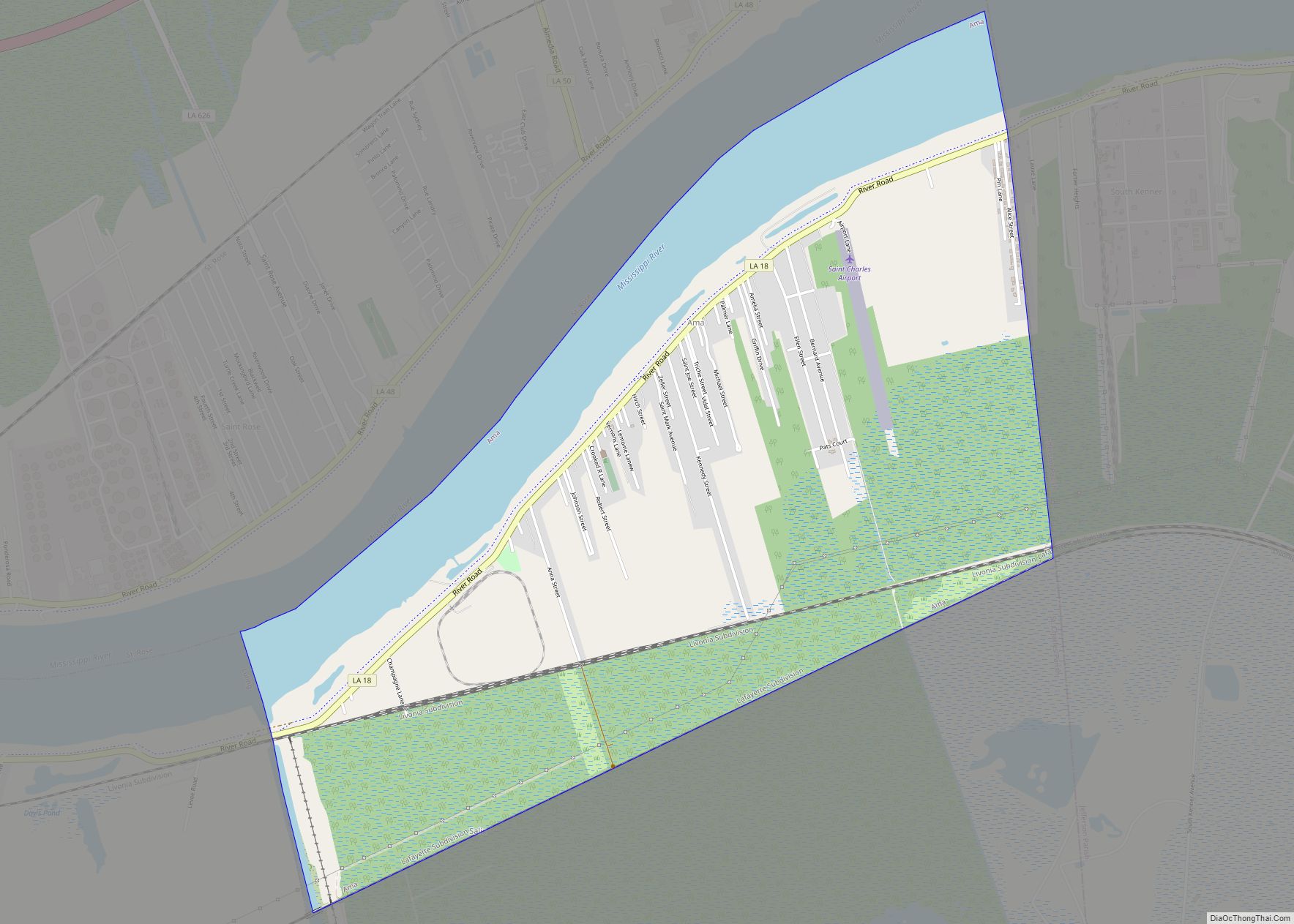
Ama is a census-designated place (CDP) in St. Charles Parish, Louisiana, United States. Ama is on the West Bank of the Mississippi River, just west of the Jefferson Parish line. The population was 1,290 at the 2020 census. Ama CDP overview: Name: Ama CDP LSAD Code: 57 LSAD Description: CDP (suffix) State: Louisiana County: St. ... Read more
Map of Ama CDP
Map of Alexandria city, Louisiana
Alexandria is the ninth-largest city in the state of Louisiana and is the parish seat of Rapides Parish, Louisiana, United States. It lies on the south bank of the Red River in almost the exact geographic center of the state. It is the principal city of the Alexandria metropolitan area (population 153,922) which encompasses all ... Read more
Map of Alexandria city, Louisiana
Map of Albany town, Louisiana
Albany is a town in eastern Livingston Parish, Louisiana, United States. The population was 1088 at the 2010 census. It is part of the Baton Rouge metropolitan statistical area. District 95 State Representative Sherman Q. Mack, an attorney, resides in Albany. Albany town overview: Name: Albany town LSAD Code: 43 LSAD Description: town (suffix) State: ... Read more
Map of Albany town, Louisiana
Map of Anacoco village
Anacoco is a village in Vernon Parish, Louisiana, United States. The population was 869 at the 2010 census. It is part of the Fort Polk South Micropolitan Statistical Area. Anacoco village overview: Name: Anacoco village LSAD Code: 47 LSAD Description: village (suffix) State: Louisiana County: Vernon Parish Incorporated: 1979 Elevation: 335 ft (102 m) Total Area: 3.09 sq mi ... Read more
Map of Anacoco village
Map of Amite City town
Amite City (/eɪˈmiːt/ ay-MEET or /eɪˈmɪt/ ay-MIT; commonly just Amite) is a town in and the seat of Tangipahoa Parish in southeastern Louisiana, United States. The population was 4,141 at the 2010 census. It is part of the Hammond Micropolitan Statistical Area. Amite City town overview: Name: Amite City town LSAD Code: 43 LSAD Description: ... Read more
Map of Amite City town
Map of Amelia CDP, Louisiana
Amelia is a census-designated place (CDP) in St. Mary Parish, Louisiana, United States. The population was 2,459 at the 2010 census. It is part of the Morgan City Micropolitan Statistical Area. Amelia CDP overview: Name: Amelia CDP LSAD Code: 57 LSAD Description: CDP (suffix) State: Louisiana County: St. Mary Parish Elevation: 7 ft (2 m) Total Area: ... Read more
Map of Amelia CDP, Louisiana
Map of Arcadia town, Louisiana
Arcadia is a town in, and the parish seat of, Bienville Parish in northern Louisiana, United States. The population was 2,919 at the 2010 census. Arcadia has the highest elevation of any incorporated municipality in Louisiana. Arcadia’s name commemorates the Ancient Greek region of Arcadia. Arcadia town overview: Name: Arcadia town LSAD Code: 43 LSAD ... Read more
Map of Arcadia town, Louisiana
Map of Arabi CDP, Louisiana
Arabi (/ˈærəbi/) is a census-designated place (CDP) in St. Bernard Parish, Louisiana, United States. It lies on the eastern bank of the Mississippi River, between the Lower 9th Ward of New Orleans and Chalmette within the Greater New Orleans metropolitan area. The population was 4,533 at the 2020 census. Arabi CDP overview: Name: Arabi CDP ... Read more
Map of Arabi CDP, Louisiana
Map of Angie village
Angie is a village in Washington Parish, Louisiana, United States. The population was 240 at the 2000 census. It is part of the Bogalusa Micropolitan Statistical Area. Angie village overview: Name: Angie village LSAD Code: 47 LSAD Description: village (suffix) State: Louisiana County: Washington Parish Incorporated: 1908 Elevation: 141 ft (43 m) Total Area: 1.54 sq mi (3.98 km²) Land ... Read more
Map of Angie village
Map of Athens village, Louisiana
Athens is a village in Claiborne Parish, Louisiana, United States. The population was 249 at the 2010 census. Athens village overview: Name: Athens village LSAD Code: 47 LSAD Description: village (suffix) State: Louisiana County: Claiborne Parish Incorporated: 1902 Elevation: 302 ft (92 m) Total Area: 3.50 sq mi (9.07 km²) Land Area: 3.50 sq mi (9.07 km²) Water Area: 0.00 sq mi (0.00 km²) Total Population: ... Read more
Map of Athens village, Louisiana
Map of Ashland village, Louisiana
Ashland is a village in the northernmost portion of Natchitoches Parish, Louisiana, United States. A few residences and a convenience store to the north spill over into neighboring Bienville Parish. The population was 291 at the 2000 census but declined 9 percent to 269 in 2010. The median age was 45.7 years. Ashland is part ... Read more
Map of Ashland village, Louisiana
Map of Arnaudville town
Arnaudville is a town in St. Landry and St. Martin parishes in the U.S. state of Louisiana. The St. Martin Parish portion of Arnaudville is part of the Lafayette metropolitan statistical area, while the St. Landry Parish portion is part of the Opelousas–Eunice micropolitan statistical area. At the 2020 population estimates program, it had a ... Read more
Map of Arnaudville town