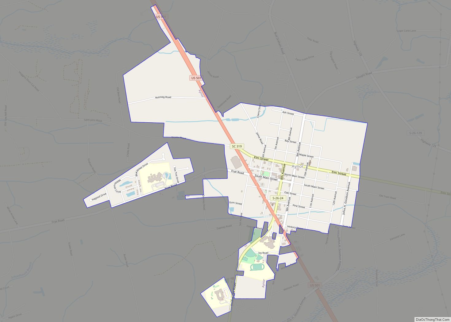
Map of Atlantic Beach town, South Carolina

Map of Atlantic Beach town, South Carolina

Atlantic Beach is a town in Horry County, South Carolina, United States, part of the Grand Strand tourist region. The population was 334 at the 2010 census. Most of the land around the town is annexed into the city of North Myrtle Beach. Atlantic Beach town overview: Name: Atlantic Beach town LSAD Code: 43 LSAD … Read more

Map of Bonneau Beach CDP

Map of Bonneau Beach CDP

Bonneau Beach is a census-designated place (CDP) in Berkeley County, South Carolina, United States. The population was 1,929 at the 2010 census. It is located on the shore of Lake Moultrie. Bonneau Beach CDP overview: Name: Bonneau Beach CDP LSAD Code: 57 LSAD Description: CDP (suffix) State: South Carolina County: Berkeley County Elevation: 75 ft (23 m) … Read more

Map of Boiling Springs CDP, South Carolina

Map of Boiling Springs CDP, South Carolina

Boiling Springs is a census-designated place (CDP) in Spartanburg County, South Carolina, United States. The population was 8,219 at the 2010 census. Boiling Springs CDP overview: Name: Boiling Springs CDP LSAD Code: 57 LSAD Description: CDP (suffix) State: South Carolina County: Spartanburg County Elevation: 919 ft (280 m) Total Area: 6.84 sq mi (17.71 km²) Land Area: 6.84 sq mi (17.71 km²) Water … Read more

Map of Blythewood town

Map of Blythewood town

Blythewood is a town in Richland and Fairfield counties, South Carolina, United States. It is a suburb of Columbia, South Carolina. The 2020 United States census puts the population at 4,772. It is part of the Columbia, South Carolina, Metropolitan Statistical Area. It is located around 15 miles (24 kilometers) from downtown Columbia. Blythewood Road … Read more

Map of Bluffton town, South Carolina

Map of Bluffton town, South Carolina

Bluffton is a town in southern Beaufort County, South Carolina, United States. The population as of the 2020 census was 27,716, an increase of over 120% since 2010, making it one of the fastest growing municipalities in South Carolina. Bluffton is the fifth largest municipality in South Carolina by land area. It is primarily located … Read more

Map of Blenheim town

Map of Blenheim town

Blenheim /ˈblɪnəm/ is a town in Marlboro County, South Carolina, United States. The population was 154 at the 2010 census. It is named for Blenheim Palace in Oxfordshire, England. Blenheim Palace was the residence of the Duke of Marlborough, after whom Marlboro County is named. Blenheim Ginger Ale was originally bottled in Blenheim, with the … Read more

Map of Blackville town

Map of Blackville town

Blackville is a small town in Barnwell County, South Carolina, United States. The population was 2,406 at the 2010 census. The town was named after Alexander Black, a railroad promoter. Blackville town overview: Name: Blackville town LSAD Code: 43 LSAD Description: town (suffix) State: South Carolina County: Barnwell County Elevation: 292 ft (89 m) Total Area: 9.03 sq mi … Read more

Map of Blacksburg town

Map of Blacksburg town, South Carolina

Blacksburg is a small town in Cherokee County, South Carolina, United States. The population was 1,848 at the 2010 census. The communities of Cherokee Falls, Kings Creek, Cashion Crossroads, Buffalo, and Mount Paran are located near the town. Blacksburg is in Upstate South Carolina on the Interstate 85 corridor about 45 mi (72 km) southwest of Charlotte, … Read more

Map of Bishopville city, South Carolina

Map of Bishopville city, South Carolina

Bishopville is a town in Lee County, South Carolina, United States. The population was 3,471 at the 2010 census. It is the county seat of Lee County. Bishopville city overview: Name: Bishopville city LSAD Code: 25 LSAD Description: city (suffix) State: South Carolina County: Lee County Elevation: 226 ft (69 m) Total Area: 2.37 sq mi (6.14 km²) Land Area: … Read more

Map of Bethune town, South Carolina

Map of Bethune town, South Carolina

Bethune is a small town in Kershaw County, South Carolina, United States. The population was 334 at the 2010 census. It is part of the Columbia, South Carolina Metropolitan Statistical Area. Bethune town overview: Name: Bethune town LSAD Code: 43 LSAD Description: town (suffix) State: South Carolina County: Kershaw County Elevation: 289 ft (88 m) Total Area: … Read more

Map of Berea CDP, South Carolina

Map of Berea CDP, South Carolina

Berea is a census-designated place (CDP) in Greenville County, South Carolina, United States. The population was 14,295 at the 2010 census. It is part of the Greenville–Mauldin–Easley Metropolitan Statistical Area. Berea CDP overview: Name: Berea CDP LSAD Code: 57 LSAD Description: CDP (suffix) State: South Carolina County: Greenville County Elevation: 1,040 ft (320 m) Total Area: 7.93 sq mi … Read more

Map of Briarcliffe Acres town

Map of Briarcliffe Acres town

Briarcliffe Acres is a town in Horry County, South Carolina, United States, located between Myrtle Beach and North Myrtle Beach. The population was 457 at the 2010 census. Briarcliffe Acres town overview: Name: Briarcliffe Acres town LSAD Code: 43 LSAD Description: town (suffix) State: South Carolina County: Horry County Elevation: 30 ft (9 m) Total Area: 0.64 sq mi … Read more