Map of Louisville city, Tennessee

Map of Louisville city, Tennessee

Louisville is a suburban town in Blount County, Tennessee, United States. Its population was 4,384 at the 2020 census and 2,439 at the 2010 census. It is included in the Knoxville, Tennessee Metropolitan Statistical Area. Louisville city overview: Name: Louisville city LSAD Code: 25 LSAD Description: city (suffix) State: Tennessee County: Blount County Elevation: 837 ft … Read more

Map of Loudon town, Tennessee

Map of Loudon town, Tennessee

Loudon is a city in and the county seat of Loudon County, Tennessee, United States. Its population was 6,001 at the 2020 census. It is included in the Knoxville, Tennessee Metropolitan Statistical Area. The city is located in East Tennessee, southwest of Knoxville, on the Tennessee River. Fort Loudoun, the colonial era fort for which … Read more

Map of Loretto city, Tennessee

Map of Loretto city, Tennessee

Loretto is a city in Lawrence County, Tennessee, United States. The population was 1,714 at the 2010 census, and 1,739 at the 2020 census. Loretto city overview: Name: Loretto city LSAD Code: 25 LSAD Description: city (suffix) State: Tennessee County: Lawrence County Elevation: 825 ft (251 m) Total Area: 3.79 sq mi (9.81 km²) Land Area: 3.78 sq mi (9.80 km²) Water Area: … Read more

Map of Lookout Mountain town, Tennessee

Map of Lookout Mountain town, Tennessee

Lookout Mountain is a town in Hamilton County, Tennessee, United States. The population was 2,058 at the 2020 census. Bordering its sister city of Lookout Mountain, Georgia to the south, Lookout Mountain is part of the Chattanooga, TN–GA Metropolitan Statistical Area. Lookout Mountain town overview: Name: Lookout Mountain town LSAD Code: 43 LSAD Description: town … Read more

Map of Manchester city, Tennessee

Map of Manchester city, Tennessee

Manchester is a city in Coffee County, Tennessee, United States. The population was 12,213 at the 2020 census. It is the county seat of Coffee County. The city is located halfway between Nashville and Chattanooga on Interstate 24. Manchester is part of the Tullahoma, Tennessee Micropolitan Statistical Area. Since 2002, Manchester has been the host … Read more

Map of Madisonville city, Tennessee

Map of Madisonville city, Tennessee

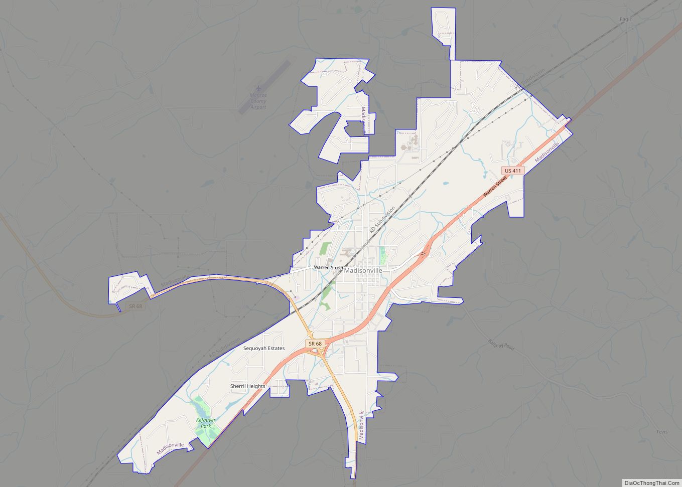
Madisonville is a city in and the county seat of Monroe County, Tennessee, United States. The population was 4,577 at the 2010 census and 5,132 at the 2020 census. Madisonville city overview: Name: Madisonville city LSAD Code: 25 LSAD Description: city (suffix) State: Tennessee County: Monroe County Founded: 1822 Incorporated: 1866 Elevation: 997 ft (304 m) Total … Read more

Map of Lynnville town, Tennessee

Map of Lynnville town, Tennessee

Lynnville is a town in Giles County, Tennessee. The population was 287 at the 2010 census. The name is from a local creek. Richland high school is located in Lynnville it serves the town and surrounding areas Lynnville town overview: Name: Lynnville town LSAD Code: 43 LSAD Description: town (suffix) State: Tennessee County: Giles County … Read more

Map of Lynchburg, Moore County metropolitan government

Map of Lynchburg, Moore County metropolitan government

Lynchburg is a city in the south-central region of the U.S. state of Tennessee. It is governed by a consolidated city-county government unit whose boundaries coincide with those of Moore County. Lynchburg is best known as the location of Jack Daniel’s, whose famous Tennessee whiskey is marketed worldwide as the product of a city with … Read more

Map of Lyles CDP

Map of Lyles CDP

Lyles is a rural census-designated place and unincorporated community in Hickman County, Tennessee, United States. Lyles CDP overview: Name: Lyles CDP LSAD Code: 57 LSAD Description: CDP (suffix) State: Tennessee County: Hickman County Elevation: 866 ft (264 m) Total Area: 2.62 sq mi (6.78 km²) Land Area: 2.62 sq mi (6.78 km²) Water Area: 0.00 sq mi (0.00 km²) Total Population: 763 Population Density: 291.33/sq mi (112.47/km²) … Read more

Map of McMinnville city, Tennessee

Map of McMinnville city, Tennessee

McMinnville is the largest city in and the county seat of Warren County, Tennessee, United States. The population was 13,605 at the 2010 census. It was named for Governor Joseph McMinn. McMinnville city overview: Name: McMinnville city LSAD Code: 25 LSAD Description: city (suffix) State: Tennessee County: Warren County Founded: August 4, 1810 Incorporated: 1868 … Read more

Map of McLemoresville town

Map of McLemoresville town

McLemoresville is a town in Carroll County, Tennessee, United States. The population was 352 at the 2010 census. It is notable primarily as the birthplace, and final resting place, of television star Dixie Carter and her husband, actor Hal Holbrook. McLemoresville town overview: Name: McLemoresville town LSAD Code: 43 LSAD Description: town (suffix) State: Tennessee … Read more

Map of McKenzie city, Tennessee

Map of McKenzie city, Tennessee

McKenzie is a city at the tripoint of Carroll, Henry, and Weakley counties in Tennessee, United States. The population was 5,310 at the 2010 census. It is home to Bethel University and the Tennessee College of Applied Technology at McKenzie. McKenzie city overview: Name: McKenzie city LSAD Code: 25 LSAD Description: city (suffix) State: Tennessee … Read more