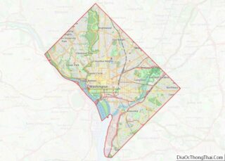
Map of Grant County, South Dakota
Grant County is a county in the U.S. state of South Dakota. As of the 2020 United States Census, the population was 7,556. The county seat is Milbank. The county was founded in 1873 and organized in 1878. It is named for Ulysses S. Grant, 18th President of the United States. Grant County overview: Name: ... Read more
Map of Grant County, South Dakota
Map of Lincoln County, South Dakota
Lincoln County is a county in the U.S. state of South Dakota. As of the 2020 United States Census, the population was 65,161, making it the third-most populated county in the state. Its county seat is Canton. The county was named for Abraham Lincoln, 16th President of the United States. Lincoln County is included in ... Read more
Map of Lincoln County, South Dakota
Map of Spink County, South Dakota
Spink County is a county in the U.S. state of South Dakota. As of the 2020 census, the population was 6,361. Its county seat is Redfield. The county was created in 1873, and was organized in 1879 within Dakota Territory. Spink County overview: Name: Spink County FIPS code: 46-115 State: South Dakota Founded: 1873 Named ... Read more
Map of Spink County, South Dakota
Map of Campbell County, Tennessee
Campbell County is a county in the U.S. state of Tennessee. It is located on the state’s northern border in East Tennessee. As of the 2020 census, its population was 39,272. Its county seat is Jacksboro. Campbell County is included in the Knoxville metropolitan statistical area. Campbell County overview: Name: Campbell County FIPS code: 47-013 ... Read more
Map of Campbell County, Tennessee
Map of Dyer County, Tennessee
Dyer County is a county located in the westernmost part of the U.S. state of Tennessee. As of the 2020 census, the population was 36,801. The county seat is Dyersburg. Dyer County comprises the Dyersburg, TN Micropolitan Statistical Area. Dyer County overview: Name: Dyer County FIPS code: 47-045 State: Tennessee Founded: 1823 Named for: Robert ... Read more
Map of Dyer County, Tennessee
Map of Henderson County, Tennessee
Henderson County is a county located in the U.S. state of Tennessee. As of the 2020 census, the population was 27,842. Its county seat is Lexington. The county was founded in 1821 and named for James Henderson, a soldier in the War of 1812. Henderson County overview: Name: Henderson County FIPS code: 47-077 State: Tennessee ... Read more
Map of Henderson County, Tennessee
Map of Madison County, Tennessee
Madison County is a county located in the western part of the U.S. state of Tennessee. As of the 2020 census, the population was 98,823. Its county seat is Jackson. Madison County is included in the Jackson, TN Metropolitan Statistical Area. Madison County overview: Name: Madison County FIPS code: 47-113 State: Tennessee Founded: 1821 Named ... Read more
Map of Madison County, Tennessee
Map of Putnam County, Tennessee
Putnam County is a county located in the U.S. state of Tennessee. As of the 2020 census, the population was 79,854. Its county seat is Cookeville. Putnam County is part of the Cookeville, TN Micropolitan Statistical Area. Putnam County overview: Name: Putnam County FIPS code: 47-141 State: Tennessee Founded: February 11, 1854 Named for: Israel ... Read more
Map of Putnam County, Tennessee
Map of Union County, Tennessee
Union County is a county located in the U.S. state of Tennessee. As of the 2020 census, its population was 19,802. Its county seat is Maynardville. Union County is included in the Knoxville metropolitan statistical area. Union County overview: Name: Union County FIPS code: 47-173 State: Tennessee Founded: January 23, 1856 Named for: Either its ... Read more
Map of Union County, Tennessee
Map of Austin County, Texas
Austin County is a rural, agricultural dominated county in the U.S. state of Texas. As of the 2020 census, the population was 30,167. Its seat is Bellville. The county and region was settled primarily by German emigrants in the 1800s. Austin County is included in the Houston–The Woodlands–Sugar Land Metropolitan Statistical Area. Austin County does not ... Read more
Map of Austin County, Texas
Map of Brooks County, Texas
Brooks County is a county in Texas, and Falfurrias is its county seat. Its population was 7,076, about 88% Latino per the 2020 census. It is one of Texas’s poorest counties. The county is named for James Abijah Brooks, one of the “Four Captains” who modernized the Texas Rangers. He retired to Farfurrias, served two ... Read more
Map of Brooks County, Texas
Map of Cochran County, Texas
Cochran County is a county located in the U.S. state of Texas. As of the 2020 census, its population was 2,547. The county seat is Morton. The county was created in 1876 and later organized in 1924. It is named for Robert E. Cochran, a defender of the Alamo. Cochran County overview: Name: Cochran County ... Read more
Map of Cochran County, Texas