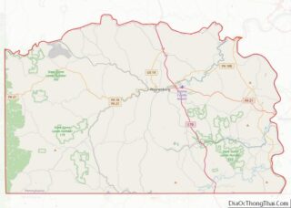
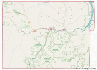
Map of Crook County

Map of Crook County, Oregon

Crook County is one of the 36 counties in the U.S. state of Oregon. As of the 2020 census, the population was 24,738. The county seat is Prineville. The county is named after George Crook, a U.S. Army officer who served in the American Civil War and various Indian Wars. Crook County comprises the Prineville, … Read more

Map of Malheur County

Map of Malheur County, Oregon

Malheur County (/mælˈhɪər/) is one of the 36 counties in the U.S. state of Oregon. As of the 2020 census, the population was 31,571. Its county seat is Vale, and its largest city is Ontario. The county was named after the Malheur River, which runs through the county. The word “malheur” is French for misfortune … Read more

Map of Armstrong County

Map of Armstrong County, Pennsylvania

Armstrong County is a county in the Commonwealth of Pennsylvania. As of the 2020 census, the population was 65,558. The county seat is Kittanning. The county was organized on March 12, 1800, from parts of Allegheny, Westmoreland and Lycoming Counties. It was named in honor of John Armstrong, who represented Pennsylvania in the Continental Congress … Read more

Map of Columbia County

Map of Columbia County, Pennsylvania

Columbia County is a county in the Commonwealth of Pennsylvania. It is located in Northeastern Pennsylvania. As of the 2020 census, the population was 64,727. Its county seat is Bloomsburg. The county was created on March 22, 1813, from part of Northumberland County. It was named Columbia, alluding to the United States and Christopher Columbus. … Read more

Map of Lackawanna County

Map of Lackawanna County, Pennsylvania

Lackawanna County (/lækəˈwɑːnə/; Unami: Lèkaohane) is a county in the Commonwealth of Pennsylvania. It is located in Northeastern Pennsylvania and had a population of 215,896 as of the 2020 census. Its county seat and largest city is Scranton. The county was created on August 13, 1878, following decades of trying to gain its independence from … Read more

Map of Philadelphia County

Map of Philadelphia County, Pennsylvania

Philadelphia County is a county in the Commonwealth of Pennsylvania. It is the most populous county in Pennsylvania and the 24th most populous county in the nation. As of the 2020 census, Philadelphia County had a population of 1,603,797. Its county seat is Philadelphia, the nation’s sixth-largest city. Philadelphia County is one of the three … Read more

Map of York County

Map of York County, Pennsylvania

York County (Pennsylvania Dutch: Yarrick Kaundi) is a county in the Commonwealth of Pennsylvania. As of the 2020 census, the population was 456,438. Its county seat is York. The county was created on August 19, 1749, from part of Lancaster County and named either after the Duke of York, an early patron of the Penn … Read more

Map of Cherokee County

Map of Cherokee County, South Carolina

Cherokee County is a county in the U.S. state of South Carolina. As of the 2020 census, the population was 56,216. The county seat is Gaffney. The county was formed in 1897 from parts of York, Union, and Spartanburg Counties. It was named for the Cherokee people who historically occupied this area prior to European … Read more

Map of Jasper County

Map of Jasper County, South Carolina

Jasper County is the southernmost county in the U.S. state of South Carolina. As of the 2020 census, the population was 28,791. Its county seat is Ridgeland and its largest city is Hardeeville. The county was formed in 1912 from portions of Hampton County and Beaufort County. Jasper County is included in the Hilton Head … Read more

Map of Sumter County

Map of Sumter County, South Carolina

Sumter County is a county located in the U.S. state of South Carolina. As of the 2020 census, the population was 105,556. In a 2018 census estimate, the population was 106,512. Its county seat is Sumter. Sumter County comprises the Sumter, South Carolina Metropolitan Statistical Area, which, combined with neighboring Lee and Clarendon counties, formed … Read more

Map of Clay County

Map of Clay County, South Dakota

Clay County is a county in the U.S. state of South Dakota. As of the 2020 United States Census, the population was 14,967. The county seat is Vermillion, which is also home to the University of South Dakota. The county is named for Henry Clay, American statesman, US Senator from Kentucky, and United States Secretary … Read more

Map of Hand County

Map of Hand County, South Dakota

Hand County is a county in the U.S. state of South Dakota. As of the 2020 census, the population was 3,145. Its county seat is Miller. Hand County overview: Name: Hand County FIPS code: 46-059 State: South Dakota Founded: 1873 Named for: George A. Hand Seat: Miller Largest city: Miller Total Area: 1,440 sq mi (3,700 km²) Land … Read more