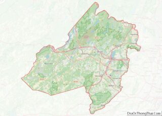
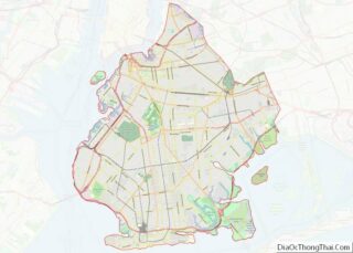
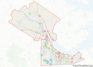
Jefferson County is a county in Montana, United States. As of the 2020 census, the population was 12,085. Its county seat is Boulder. The county was created in 1865 and named for President Thomas Jefferson. Jefferson County is part of the Helena, MT Micropolitan Statistical Area. Jefferson County overview: Name: Jefferson County FIPS code: 30-043 ... Read more
Map of US Counties
Powder River County is a county in the U.S. state of Montana. As of the 2020 census, the population was 1,694. Its county seat is Broadus. Powder River County overview: Name: Powder River County FIPS code: 30-075 State: Montana Founded: March 17, 1919 Named for: Powder River Seat: Broadus Largest town: Broadus Total Area: 3,298 sq mi ... Read more
Wheatland County is a county in the U.S. state of Montana. As of the 2020 census, the population was 2,069. Its county seat is Harlowton. Wheatland County was established on February 22, 1917, with areas partitioned from Meagher and Sweet Grass counties. It was named for the abundant wheat-growing areas across the center portion of ... Read more
Cedar County is a county in the U.S. state of Nebraska. As of the 2010 United States Census, the population was 8,852. The county seat is Hartington. The county was formed in 1857, and was named for the Cedar tree groves in the area. In the Nebraska license plate system, Cedar County is represented by ... Read more
Fillmore County is a county located in the U.S. state of Nebraska. As of the 2010 United States Census, the population was 5,890. Its county seat is Geneva. The county was named for President Millard Fillmore. In the Nebraska license plate system, Fillmore County is represented by the prefix 34 (it had the thirty-fourth largest ... Read more
Hooker County overview: Name: Hooker County FIPS code: 31-091 State: Nebraska Founded: 1889 Named for: Joseph Hooker Seat: Mullen Total Area: 721 sq mi (1,870 km²) Land Area: 721 sq mi (1,870 km²) Total Population: 734 Population Density: 0.9/sq mi (0.3/km²) Time zone: UTC−7 (Mountain) Summer Time Zone (DST): UTC−6 (MDT) Website: www.co.hooker.ne.us Hooker County location map. Where is Hooker County? History ... Read more
Morrill County is a county in the U.S. state of Nebraska. As of the 2010 United States Census, the population was 5,042. Its county seat is Bridgeport. In the Nebraska license plate system, Morrill County is represented by the prefix 64 (it had the 64th-largest number of vehicles registered in the state when the license ... Read more
Saunders County is a county in the U.S. state of Nebraska. As of the 2010 United States Census, the population was 22,278. Its county seat is Wahoo. Saunders County is included in the Omaha–Council Bluffs metropolitan area. In the Nebraska license plate system, Saunders County is represented by the prefix 6 (the county had the ... Read more
Carson City is an independent city and the capital of the U.S. state of Nevada. As of the 2020 census, the population was 58,639, making it the sixth largest city in Nevada. The majority of the city’s population lives in Eagle Valley, on the eastern edge of the Carson Range, a branch of the Sierra ... Read more
White Pine County overview: Name: White Pine County FIPS code: 32-033 State: Nevada Founded: 1869 Named for: Rocky Mountain white pine Seat: Ely Largest city: Ely Total Area: 8,897 sq mi (23,040 km²) Land Area: 8,876 sq mi (22,990 km²) Total Population: 9,080 Population Density: 1.0/sq mi (0.39/km²) Time zone: UTC−8 (Pacific) Summer Time Zone (DST): UTC−7 (PDT) Website: whitepinecounty.net White Pine ... Read more
Cumberland County overview: Name: Cumberland County FIPS code: 34-011 State: New Jersey Founded: 1748 Named for: Prince William, Duke of Cumberland Seat: Bridgeton Total Area: 677.62 sq mi (1,755.0 km²) Land Area: 483.70 sq mi (1,252.8 km²) Total Population: 154,152 Population Density: 318.9/sq mi (123.1/km²) Website: co.cumberland.nj.us Cumberland County location map. Where is Cumberland County? History Etymology The county is named for ... Read more
Bernalillo County (/ˌbɜːrnəˈliːjoʊ/; Spanish: Condado de Bernalillo) is the most populous county in the U.S. state of New Mexico. As of the 2020 census, the population was 676,444. The county seat, Albuquerque, is the most populous city in New Mexico. Bernalillo County is the central county of the Albuquerque, NM Metropolitan Statistical Area. Bernalillo County ... Read more