| Name: | Williamson County |
|---|---|
| FIPS code: | 48-491 |
| State: | Texas |
| Founded: | March 13, 1848 |
| Named for: | Robert McAlpin Williamson |
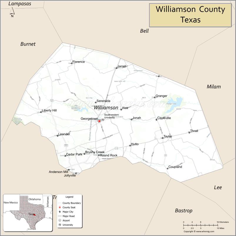
| Seat: | Georgetown |
| Largest city: | Round Rock |
| Total Area: | 1,134 sq mi (2,940 km²) |
| Land Area: | 1,118 sq mi (2,900 km²) |
| Total Population: | 609,017 |
| Population Density: | 378/sq mi (146/km²) |
| Time zone: | UTC−6 (Central) |
| Summer Time Zone (DST): | UTC−5 (CDT) |
| Website: | wilco.org |
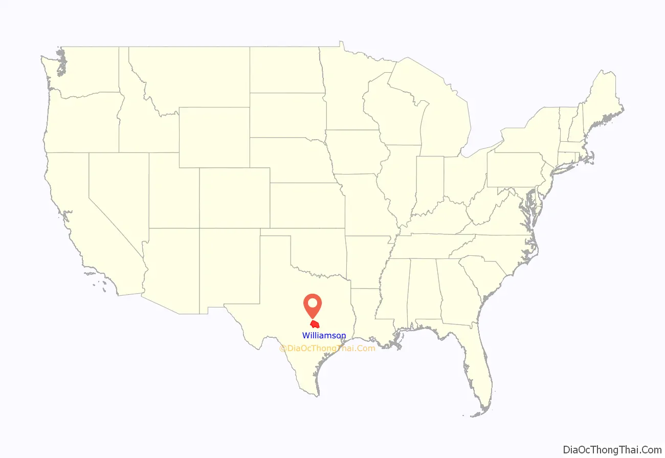
Williamson County location map. Where is Williamson County?
History
Prehistoric
Much of Williamson County has been the site of human habitation for at least 11,200 years. The earliest known inhabitants of the area lived during the late Pleistocene (Ice Age), and are linked to the Clovis culture around 9,200 BC based on evidence found at Bell County’s much-studied Gault Site. One of the most important discoveries in recent times is the ancient skeletal remains dubbed the “Leanderthal Lady” because of its age and proximity to Leander, Texas. It was discovered by accident by the Texas Department of Transportation workers while drilling core samples for a new highway. The site has been extensively studied for many years, and samples from this site carbon date to the Pleistocene period around 10,500 years ago. Prehistoric and Archaic “open occupation” campsites are also found throughout the county along streams and other water sources, including Brushy Creek in Round Rock and the San Gabriel River in Georgetown. Such evidence of Archaic-period inhabitants is often in the form of relics and flint tools recovered from burned rock middens. Many such sites were inundated when the San Gabriel River was dammed to create Lake Granger.
The earliest known historical Native American occupants, the Tonkawa, were a flint-working, hunting people who followed the buffalo on foot and periodically set fire to the prairie to aid them in their hunts. During the 18th century, they made the transition to a horse culture and used firearms to a limited extent. After they were crowded out by white settlement, the Comanches continued to raid settlements in the county until the 1860s. Also, small numbers of Kiowa, Yojuane, Tawakoni, and Mayeye Indians apparently were living in the county at the time of the earliest Anglo settlements.
Thrall flood
On September 9 and 10, 1921, the remnants of a hurricane moved over Williamson County. The center of the storm became stationary over Thrall, a small farming town in eastern Williamson County, dropping a storm total of 39.7 in (1,010 mm) of rain in 36 hours. The 24-hour rainfall total ending 7 am on September 10, 1921 (38.2 in (970 mm)) at a U.S. Weather Bureau station in Thrall remains the national official 24-hour rainfall record. Thrall’s rainfall was 23.4 in (590 mm) during 6 hours, 31.8 in (810 mm) during 12 hours, and 36.4 in (920 mm) during 18 hours. Eighty-seven people drowned in and near Taylor, and 93 in Williamson County. This storm caused the most deadly floods in Texas, with a total of 215 fatalities.
1997 tornado outbreak
On May 27, 1997, Williamson County was hit by the worst tornado outbreak in county history. The 1997 Central Texas tornado outbreak caused 20 tornadoes including an F-5 (the strongest rating used for tornadoes on the Fujita scale), which remains the only F-5 to strike Williamson County. The F-5 tornado killed 27 people and completely destroyed the Double Creek Estates neighborhood in the city of Jarrell, Texas, located in far northern Williamson County. Another strong tornado, an F-3, struck Cedar Park, killing one person. Two F-2 tornadoes also struck Williamson County. The outbreak cost the county over $190 million in damages and a total of 30 fatalities.
Modern growth
Williamson County’s fast growth rate is due in large part to its location immediately north of Austin coupled with Austin’s rapid expansion northward; Austin’s city limits cross into Williamson County. Most of the growth has been residential, but large employers, such as Dell’s international headquarters, have also changed Williamson County from a bedroom community into a community where citizens can live and work in the same general vicinity. This has transformed the county over recent years into a dynamic, self-sustaining community with less dependency on Austin. Major retail and commercial developments began appearing from 1999 to present, including the Rivery in Georgetown, and the Premium Outlet Mall, the IKEA-area retail, and the La Frontera mixed-use center in Round Rock. Health care and higher education have also become major factors in the county’s growth. Two new colleges and two new hospitals have opened since 2015. Another significant factor has been the opening of the North Loop 1 and Texas State Highway 45 toll roads, which have made Williamson County more accessible to Austin.
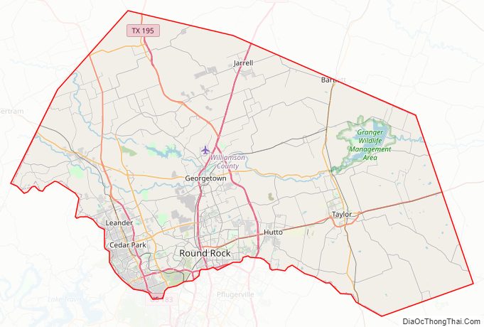
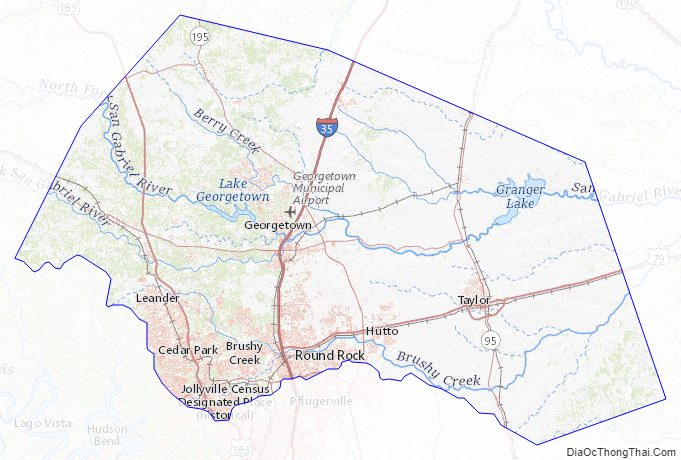
Williamson County Road Map
Geography
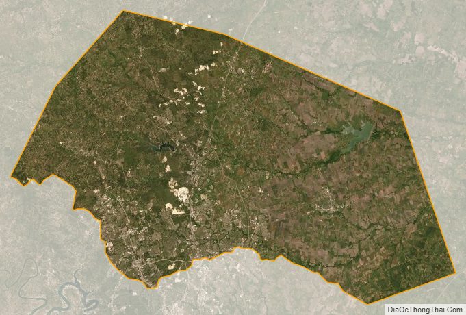
According to the U.S. Census Bureau, the county has an area of 1,134 sq mi (2,940 km), of which 1,118 square miles (2,900 km) is land and 16 square miles (41 km) (1.4%) water.
The area is divided into two regions by the Balcones Escarpment, which runs through the center from north to south along a line from Jarrell to Georgetown to Round Rock. The county’s western half is an extension of the Western Plains and considered to be within the eastern fringes of Texas Hill Country; it has an average elevation of 850 ft (260 m). It features undulating, hilly brushland with an abundance of Texas live oak, prickly pear cactus, and karst. The county’s eastern half is part of the Coastal Plains and is flat to gently rolling with an average elevation of 600 ft (180 m). It has dark clay and rich, fertile soils for agriculture, but is quickly being developed as the county’s population continues to increase and expand out. Williamson County is drained in the center and south by the San Gabriel River, the county’s only river, and in the north by creeks that run into the Lampasas and Little Rivers north of the county line.
Topography
Williamson County’s eastern portion lies within the low-lying prairie areas east of the Balcones Escarpment (also known as the Balcones Fault, though it is not an active fault). It begins a piedmont, a foot-friendly fall line of slightly sloping land downward to the coastal area, an area of the Blackland Prairie consisting of rich, fertile, clay-containing soils, where the land is still used for agriculture, growing cotton and other crops and raising cattle. These prairie lands essentially run from Williamson County to the Gulf Coast, and have a rich heritage of being farmed by German, Polish, and other settlers.
West of the escarpment is the beginning of the “upland” Texas Hill Country, characterized by rocky terrain with thin layers of soil on top of limestone. Some ranching occurs in the uplands, but mostly it has been the target of residential development because of the rolling terrain, vistas, hardwood trees, abundant wildlife, and rivers and streams (the same reason early Indians camped in the area). The Hill Country areas are characterized by their porous “vugular” (honeycombed) rock, where rainwater percolates down to replenish the Edwards Aquifer. For that reason, development restrictions are in place and several endangered species are protected by the US Fish and Wildlife Service (USFWS).Interstate 35, the county’s main artery, runs along the fault line dividing the two distinct regions.
Environmentally protected areas
Balcones Canyonlands National Wildlife Refuge is in the Texas Hill Country northwest of Austin, including parts of western Williamson County. The refuge was formed in 1992 to conserve habitat for two endangered songbirds, the golden-cheeked warbler and the black-capped vireo, and to preserve Texas Hill Country habitat for other wildlife species. The refuge augments a similarly named preserve in Austin, the Balcones Canyonlands Preserve. The vegetation found in the Hill Country includes various oaks, elms, and Ashe juniper trees (often called “cedar” in Texas). The golden-cheeked warbler and black-capped vireo depend on different successional stages of this vegetation, and both nest in the Edwards Plateau, the warbler exclusively. Some protected areas are open to visitors, such as the Berry Springs Park.
Endangered species
Williamson County is home to five endangered species. Two are songbirds protected by the Balcones Canyonlands Preserve in Travis and Williamson Counties. The other three are invertebrate species found only in Williamson County, which live in the cavelike fissures on the west side of the county. Karst topography is the name for the honeycomb-type limestone formations (including caves, sinkholes, and fissures) typical of the county’s limestone geology west of Interstate 35. In the 1990s, a group of concerned landowners, individuals, and real-estate developers formed the Northern Edwards Aquifer Resource Council with the goal of obtaining a USFWS 10-A permit (known as an incidental take permit) for the county by identifying and preserving sufficiently many caves with endangered species to ensure survival of the species. These species would be preserved through voluntary donations of land rather than required setbacks, grants, and other involuntary means typically enforced on landowners without an incidental take permit. The group transferred its successful work on an environmental impact statement to the county in 2002 and a county-wide 10-A permit was obtained in October 2008. Property owners are able to participate in the county’s 10-A permit by applying through the WCCF.
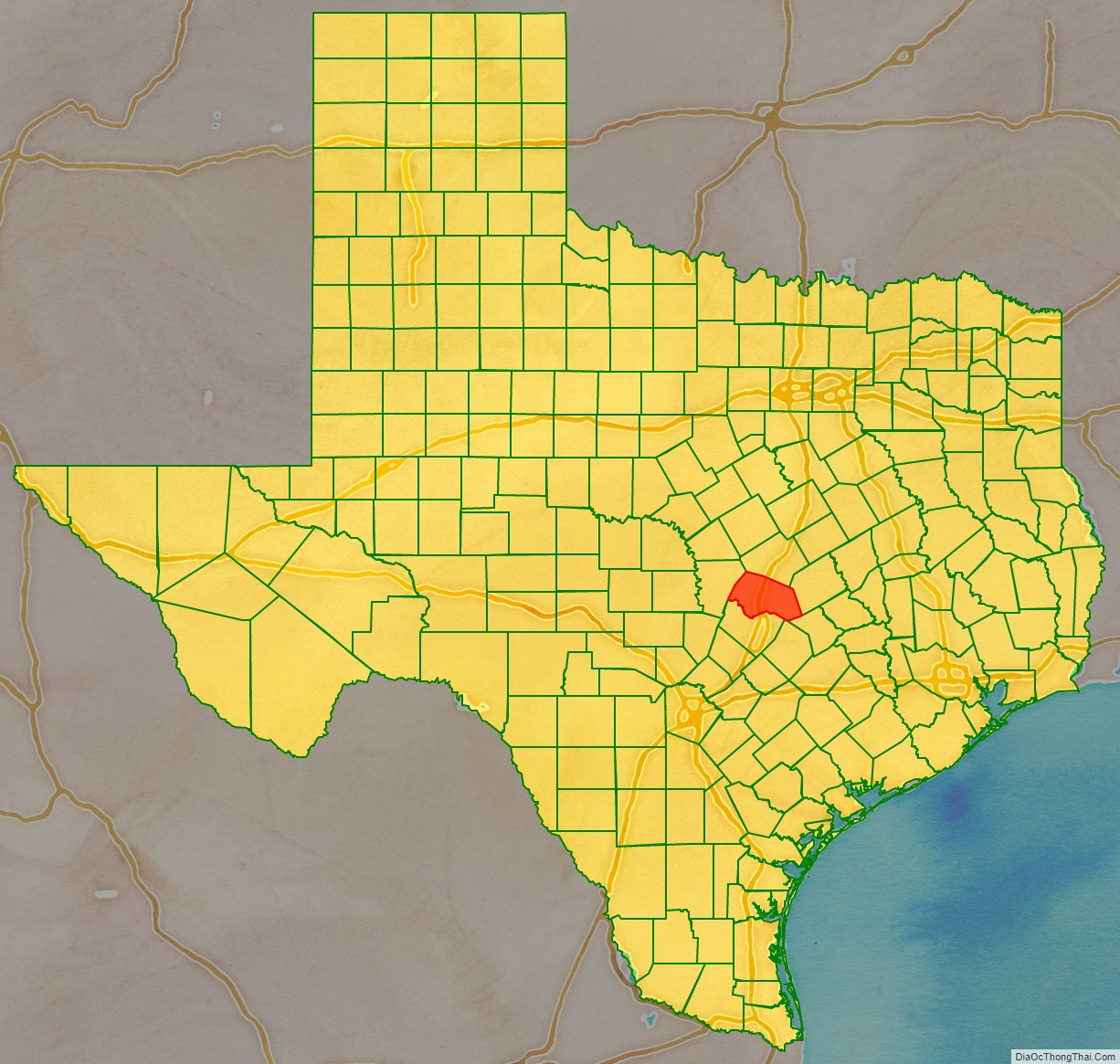
Adjacent counties
- Bell County (north)
- Milam County (east)
- Lee County (southeast)
- Bastrop County (southeast)
- Travis County (south)
- Burnet County (west)
Williamson County Topographic Map
Williamson County Satellite Map
Williamson County Outline Map