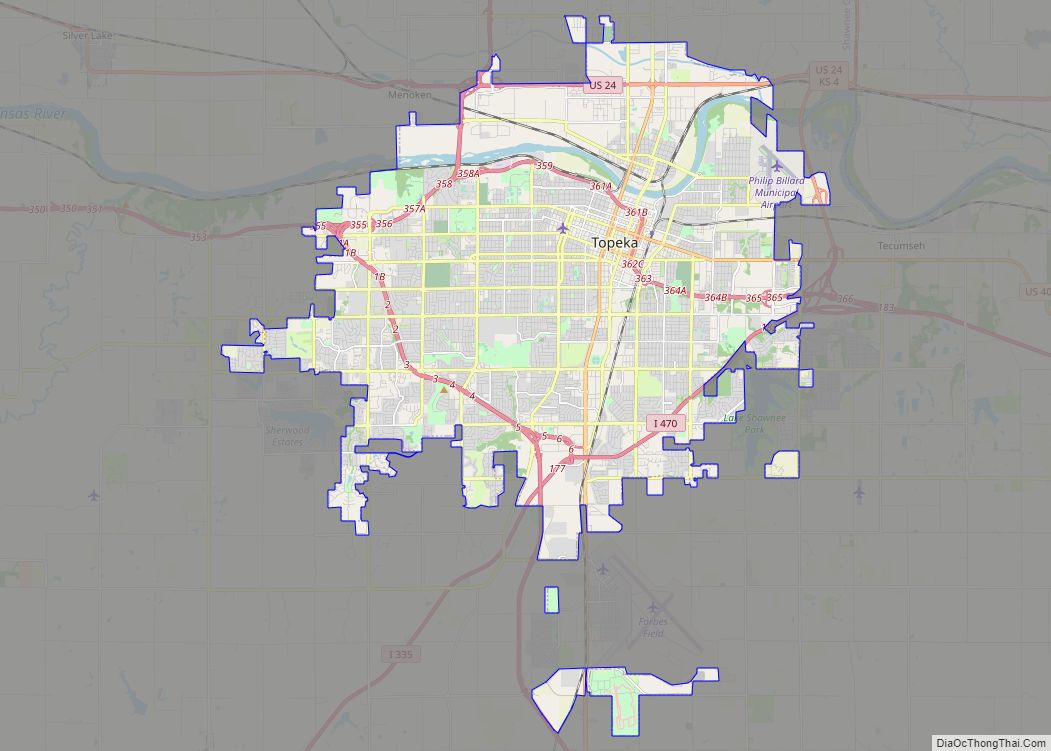
Map of Simi Valley city

Map of Simi Valley city

Simi Valley (/ˈsiːmiː/ (listen); Chumash: Shimiyi) is a city in the valley of the same name in the southeast region of Ventura County, California, United States. Simi Valley is 40 miles (65 km) from Downtown Los Angeles, making it part of the Greater Los Angeles Area. The city sits next to Thousand Oaks, Moorpark, and Chatsworth. … Read more

Map of Pearland city

Map of Pearland city

Pearland (/ˈpɛərlænd/ PEAR-land) is a city in the U.S. state of Texas, within Brazoria County, with portions extending into Fort Bend and Harris counties. The city of Pearland is a principal city within the Houston–The Woodlands–Sugar Land metropolitan statistical area. At the 2020 U.S. census, the city’s population was 125,828, up from a population of … Read more

Map of Thousand Oaks city

Map of Thousand Oaks city

Thousand Oaks is a city in the northwestern part of Greater Los Angeles, approximately 15 miles (24 km) from the city of Los Angeles and 40 miles (64 km) from Downtown. The second-largest city in Ventura County, California, it is named after the many oak trees present in the area. The city forms the central populated core … Read more

Map of Allentown city, Pennsylvania

Map of Allentown city, Pennsylvania

Allentown (Pennsylvania Dutch: Allenschteddel, Allenschtadt, or Ellsdaun) is a city in Lehigh County in the Commonwealth of Pennsylvania, United States. The city had a population of 125,845 at the 2020 census. Allentown is the fastest-growing major city in Pennsylvania and the state’s third-largest city after Philadelphia and Pittsburgh. It is the largest city in both … Read more

Map of Meridian city, Idaho

Map of Meridian city, Idaho

Meridian is a city located in Ada County in the U.S. state of Idaho. As of the 2020 census, the population of Meridian was 117,635, making it the second largest city in the county and Idaho after Boise, the state capital. Meridian is considered the state’s fastest-growing city and among the fastest-growing cities in the … Read more

Map of Concord city, California

Map of Concord city, California

Concord (/ˈkɒŋkərd/ KON-kerd) is the largest city in Contra Costa County, California. According to an estimate completed by the United States Census Bureau, the city had a population of 129,295 in 2019, making it the eighth largest city in the San Francisco Bay Area. Founded in 1869 as Todos Santos by Don Salvio Pacheco II, … Read more

Map of Vallejo city

Map of Vallejo city

Vallejo (/vəˈleɪ(h)oʊ/ və-LAY-(h)oh; Spanish: [baˈʎexo]) is a city in Solano County, California and the second largest city in the North Bay region of the Bay Area. Located on the shores of San Pablo Bay, the city had a population of 126,090 at the 2020 census. Vallejo is home to the California Maritime Academy, Touro University California … Read more

Map of Abilene city, Texas

Map of Abilene city, Texas

Abilene (/ˈæbɪliːn/ AB-i-leen) is a city in Taylor and Jones County, Texas, United States. Its population was 125,182 at the 2020 census. It is the principal city of the Abilene metropolitan statistical area, which had an estimated population of 169,893, as of 2016. Abilene is home to three Christian universities: Abilene Christian University, McMurry University, … Read more

Map of Clovis city

Map of Clovis city, California

Clovis is a city in Fresno County, California, United States. Clovis was established in 1890 as a freight stop for the San Joaquin Valley Railroad by a group of Fresno businessmen and Michigan railroad speculator Marcus Pollasky. The railroad bought the land from two farmers and named the station after one of them, Clovis Cole. … Read more

Map of Arvada city

Map of Arvada city, Colorado

Arvada (/ɑːrˈvædə/) is a home rule municipality located in Jefferson and Adams counties, Colorado, United States. The city population was 124,402 at the 2020 United States Census, with 121,510 residing in Jefferson County and 2,892 residing in Adams County. Arvada is the seventh most populous city in Colorado. The city is a part of the … Read more

Map of Lafayette city, Louisiana

Map of Lafayette city, Louisiana

Lafayette (/ˌlæfiːˈɛt, ˌlɑːf-/, French: [lafajɛt]) is a city in the U.S. state of Louisiana, and the most populous city and parish seat of Lafayette Parish, located along the Vermilion River. It is Louisiana’s fourth largest incorporated municipality by population with a 2020 census population of 121,374; the consolidated city-parish’s population was 241,753 in 2020. The Lafayette … Read more