Arvada (/ɑːrˈvædə/) is a home rule municipality located in Jefferson and Adams counties, Colorado, United States. The city population was 124,402 at the 2020 United States Census, with 121,510 residing in Jefferson County and 2,892 residing in Adams County. Arvada is the seventh most populous city in Colorado. The city is a part of the Denver–Aurora–Lakewood, CO Metropolitan Statistical Area and the Front Range Urban Corridor. The Olde Town Arvada historic district is 7 miles (11 km) northwest of the Colorado State Capitol in Denver.
| Name: | Arvada city |
|---|---|
| LSAD Code: | 25 |
| LSAD Description: | city (suffix) |
| State: | Colorado |
| County: | Adams County, Jefferson County |
| Incorporated: | August 24, 1904 |
| Elevation: | 5,344 ft (1,662 m) |
| Total Area: | 39.570 sq mi (102.485 km²) |
| Land Area: | 38.910 sq mi (100.776 km²) |
| Water Area: | 0.660 sq mi (1.709 km²) |
| Total Population: | 124,402 |
| Population Density: | 3,197/sq mi (1,234/km²) |
| ZIP code: | 80001-80007 and 80403 |
| FIPS code: | 0803455 |
| Website: | arvada.org |
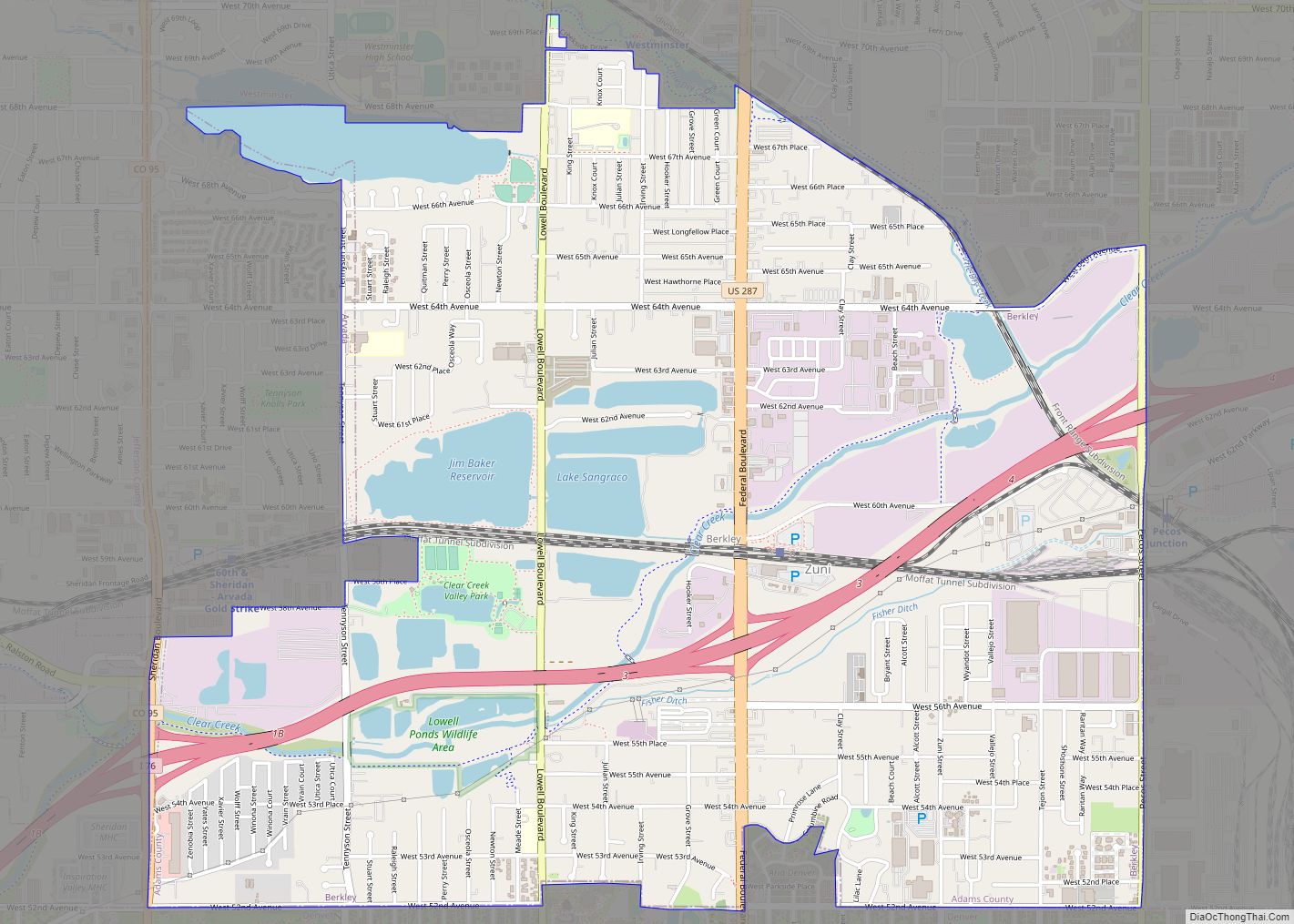
Online Interactive Map
Click on ![]() to view map in "full screen" mode.
to view map in "full screen" mode.
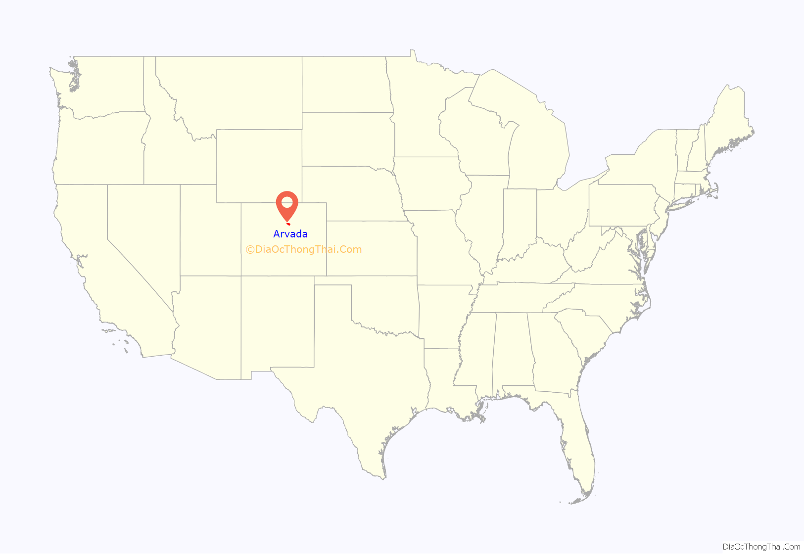
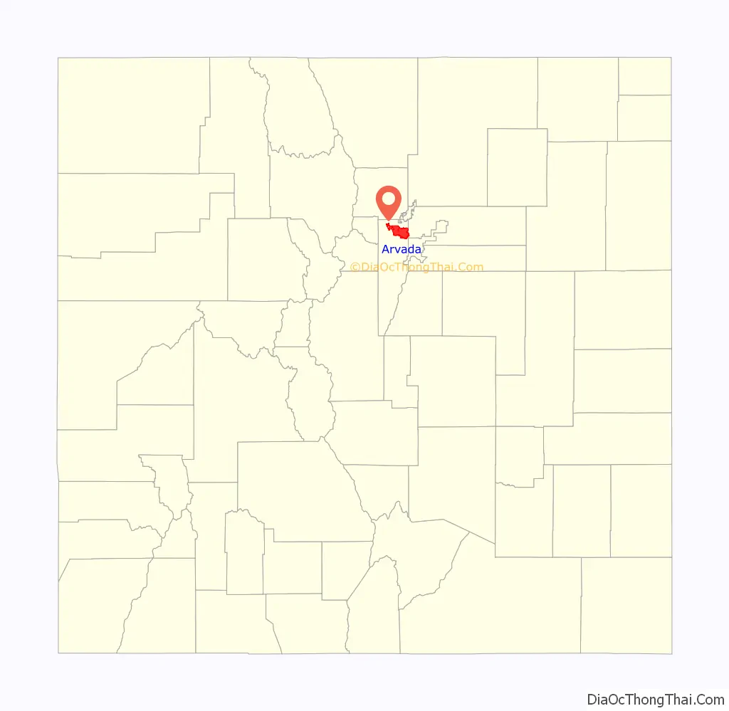
Arvada location map. Where is Arvada city?
History
The first documented discovery of gold in the Rocky Mountain region occurred on June 22, 1850, when Lewis Ralston, a Georgia prospector headed for the California gold fields, dipped his sluice pan into a small stream near its mouth at Clear Creek. Ralston found about 1/4 ounce (6 g) of gold, then worth about five dollars. Ralston’s companions named the stream Ralston’s Creek in his honor, but they all left the next morning, drawn by the lure of California gold.
During the Pike’s Peak Gold Rush in 1858, Ralston brought another group of prospectors back to the site of his first discovery. The placer gold in the area soon played out, but hard rock deposits of gold were found in the mountains to the west. Some of the miners abandoned their search for gold and returned to farm the rich bottom land along Ralston Creek and Clear Creek. They found an eager market for their crops among other gold seekers. The Territory of Colorado was formed on February 28, 1861, and the farms in the valley expanded to feed the growing population of the region.
In 1870, the Colorado Central Railroad laid tracks through the area on its route from Golden to link up with the Kansas Pacific Railroad and the Denver Pacific Railroad at Jersey Junction, 3 miles (5 km) north of Denver. On December 1, 1870, Benjamin F. Wadsworth and Louis A. Reno platted the Ralston Point townsite along the railroad. To avoid confusion with other communities along Ralston Creek, Ralston Point was soon renamed Arvada in honor of Hiram Arvada Haskin, brother-in-law of settler Mary Wadsworth. Her husband, Benjamin Wadsworth, became the first postmaster of Arvada. Colorado was granted statehood on August 1, 1876, and the Town of Arvada was formally incorporated on August 14, 1904. A vibrant agricultural community, Arvada was once known as the “Celery Capital of the World.”
Arvada grew rapidly during the latter half of the 20th century as a suburb of nearby Denver, the state capital. Arvada became a Statutory City on October 31, 1951, and a Home Rule Municipality on July 23, 1963. By the end of the millennium, the population of Arvada exceeded 100,000.
Missionary shooting
On December 9, 2007, Matthew J. Murray walked into the Youth With a Mission Center in Arvada and, after he was refused his request to stay overnight in the dormitories, opened fire and killed two people, injuring two more.
A memorial was held the following Wednesday, December 12, in which Youth With a Mission leaders forgave Murray’s family for what happened.
Olde Town Square shooting
On Monday, June 21, 2021, Ronald Troyke fatally shot Arvada police officer Gordon Beesley with a semi-automatic shotgun. Troyke then returned to his truck and retrieved an AR-15 rifle. As Troyke proceeded down the street, bystander Johnny Hurley fatally shot Troyke with a handgun. When Hurley picked up Troyke’s rifle, Arvada police officer Kraig Brownlow arrived on the scene and fatally shot Hurley, mistaking him for Beesley’s shooter. Troyke was targeting Arvada police officers in general, but his motive has not been determined. On November 8, 2021, authorities have decided not to press charges against Brownlow for killing Hurley. Troyke had reportedly been seen recording police at crime scenes.
Arvada Road Map

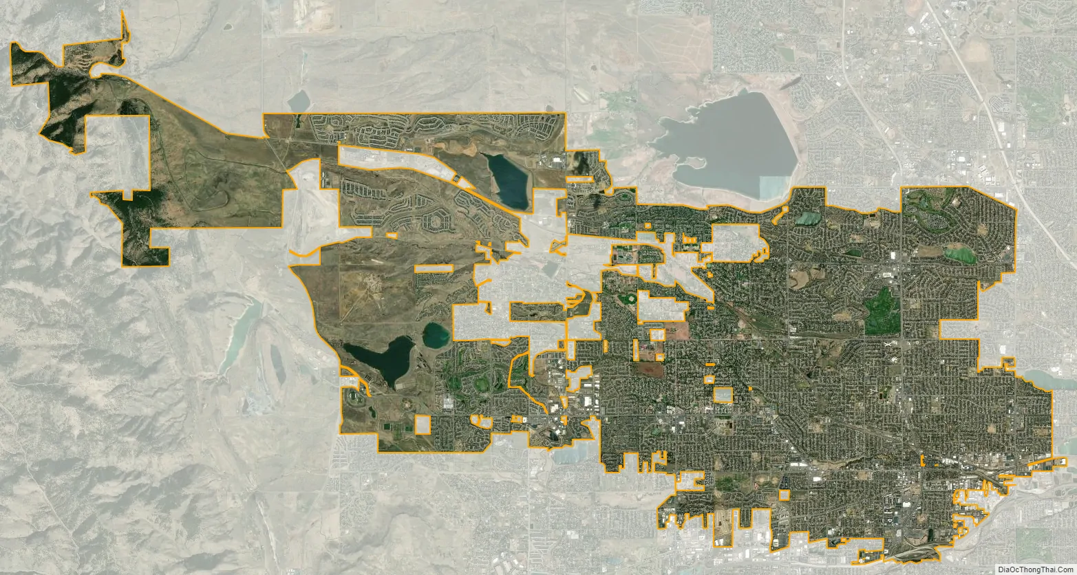
Arvada city Satellite Map
Geography
Arvada is located in northeastern Jefferson County at 39°49′12″N 105°6′40″W / 39.82000°N 105.11111°W / 39.82000; -105.11111 (39.819962, -105.110975). A small portion of the city extends east into Adams County.
At the 2020 United States Census, the city had a total area of 25,325 acres (102.485 km), including 422 acres (1.709 km) of water.
Climate
The climate is described as Humid Continental by the Köppen Climate System, abbreviated as Dfb.
See also
Map of Colorado State and its subdivision:- Adams
- Alamosa
- Arapahoe
- Archuleta
- Baca
- Bent
- Boulder
- Broomfield
- Chaffee
- Cheyenne
- Clear Creek
- Conejos
- Costilla
- Crowley
- Custer
- Delta
- Denver
- Dolores
- Douglas
- Eagle
- El Paso
- Elbert
- Fremont
- Garfield
- Gilpin
- Grand
- Gunnison
- Hinsdale
- Huerfano
- Jackson
- Jefferson
- Kiowa
- Kit Carson
- La Plata
- Lake
- Larimer
- Las Animas
- Lincoln
- Logan
- Mesa
- Mineral
- Moffat
- Montezuma
- Montrose
- Morgan
- Otero
- Ouray
- Park
- Phillips
- Pitkin
- Prowers
- Pueblo
- Rio Blanco
- Rio Grande
- Routt
- Saguache
- San Juan
- San Miguel
- Sedgwick
- Summit
- Teller
- Washington
- Weld
- Yuma
- Alabama
- Alaska
- Arizona
- Arkansas
- California
- Colorado
- Connecticut
- Delaware
- District of Columbia
- Florida
- Georgia
- Hawaii
- Idaho
- Illinois
- Indiana
- Iowa
- Kansas
- Kentucky
- Louisiana
- Maine
- Maryland
- Massachusetts
- Michigan
- Minnesota
- Mississippi
- Missouri
- Montana
- Nebraska
- Nevada
- New Hampshire
- New Jersey
- New Mexico
- New York
- North Carolina
- North Dakota
- Ohio
- Oklahoma
- Oregon
- Pennsylvania
- Rhode Island
- South Carolina
- South Dakota
- Tennessee
- Texas
- Utah
- Vermont
- Virginia
- Washington
- West Virginia
- Wisconsin
- Wyoming