Map of Haiti

Map of Haiti

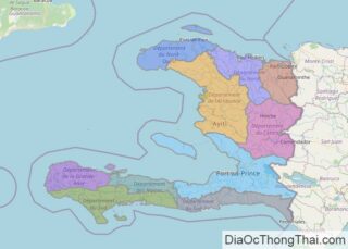
Covering an area of 27,750 sq. km (10,710 sq mi), Haiti is the 3rd largest country in the Caribbean, behind Cuba and the Dominican Republic. It occupies the western third of the island of Hispaniola and consists of two peninsulas, separated by the Gonave Gulf.  As observed on the physical map of Haiti above, it’s a rugged mountainous … Read more

Map of Kyrgyzstan

Map of Kyrgyzstan

Kyrgyzstan, a landlocked country, covers an area of 199,951 sq. km in Central Asia.  As observed on the map above, over 90% of Kyrgyzstan is dominated by massive, rugged mountain ranges, including the Alai, Kirghiz, and Tien Shan, and their associated valleys and basins. Large areas of those mountain regions are covered by glaciers. A … Read more

Map of Tajikistan

Map of Tajikistan

Tajikistan, a landlocked Central Asian country occupies an area of 143,100 sq. km. It is the region’s smallest nation.  As observed on the physical map of Tajikistan above, almost the entire country (around 93%) is mountainous. In fact, more than half of the country is higher than 3,000 m, (9,842 ft.) in elevation. The map also … Read more

Map of Malawi

Map of Malawi

The landlocked country of Malawi in southeastern Africa covers an area of 118,484 sq. km. The country can be divided into four physiographic regions. These are the Great Rift Valley, the central plateau, highland region, and isolated mountains. The Great Rift Valley traverses Malawi from north to south. As marked on the physical map of … Read more

Map of Mauritania

Map of Mauritania

Mauritania, a country in Northwest Africa, occupies an area of 1,030,000 sq. km. Mauritania has a generally flat landscape with vast plains that are punctuated by the occasional ridge or cliff-like outcropping.Bisecting the plains in the center of the country is a series of sandstone plateaus giving way to spring-fed oases.The most prominent feature of … Read more

Map of Monaco

Map of Monaco

As the second-smallest independent state in the world, after the Vatican City, Monaco is a very hilly, rugged and rocky country. The country covers an area of only 2.1 sq. km. Monaco sits on the Mediterranean Coast, and is almost entirely urban. The highest point is Mont Agel, which rises to 459 ft (140 m). … Read more

Map of Liechtenstein

Map of Liechtenstein

Liechtenstein covers a total area of 160 sq. km (62 sq mi) in Central Europe. It is a doubly landlocked country as it is surrounded by all landlocked countries. It is very small in size, barely the size of Washington DC, in the United States. As observed on the physical map of Lichtenstein, the Alpine … Read more

Map of Guam

Map of Guam

Covering an area of 540 sq.km (210 sq mi), Guam is an organized unincorporated territory of the United States in Micronesia; and the southernmost and largest island in the Mariana Island chain, located in the western North Pacific Ocean. The island is volcanic in origin, and ringed by steep coastal cliffs and sandy beaches. As observed on … Read more

Map of Maldives

Map of Maldives

Maldives is an archipelagic nation with a total land area of 298 sq. km in the Indian Ocean. It is Asia’s smallest country. Here, over 1,110 islands are grouped into a double chain of 26 atolls. The islands of the country are dispersed across about 90,000 sq. km of the ocean. This fact makes Maldives … Read more

Map of Bermuda

Map of Bermuda

Covering a total area of 53.3 sq. km, the British Overseas Territory of Bermuda (generally referred to as a singular territory) actually consists of 181 islands, of which the Main Island is the largest. Bermuda is located 918 km (570 miles) east-southeast of Cape Hatteras, North Carolina and 1,250km (775 miles) southeast of New York … Read more

Map of Fiji

Map of Fiji

Covering an area of 18,300 sq.km (7,056 sq mi), the island nation of Fiji is located in the South Pacific Ocean, some 1,300 miles (2,000 km) northeast of New Zealand’s North Island; comprising of more than 332 islands of which 110 are inhabited, along with an additional 500 islets. The two largest islands as shown on the … Read more

Map of Montenegro

Map of Montenegro

The southeast European country of Montenegro occupies an area of 13,812 sq. km.  As observed on the physical map of Montenegro, the country is highly mountainous. Ranging from towering peaks along the Serbian and Albanian borders to a small coastal plain, it is home to a diverse landscape due to its position on the Balkan … Read more