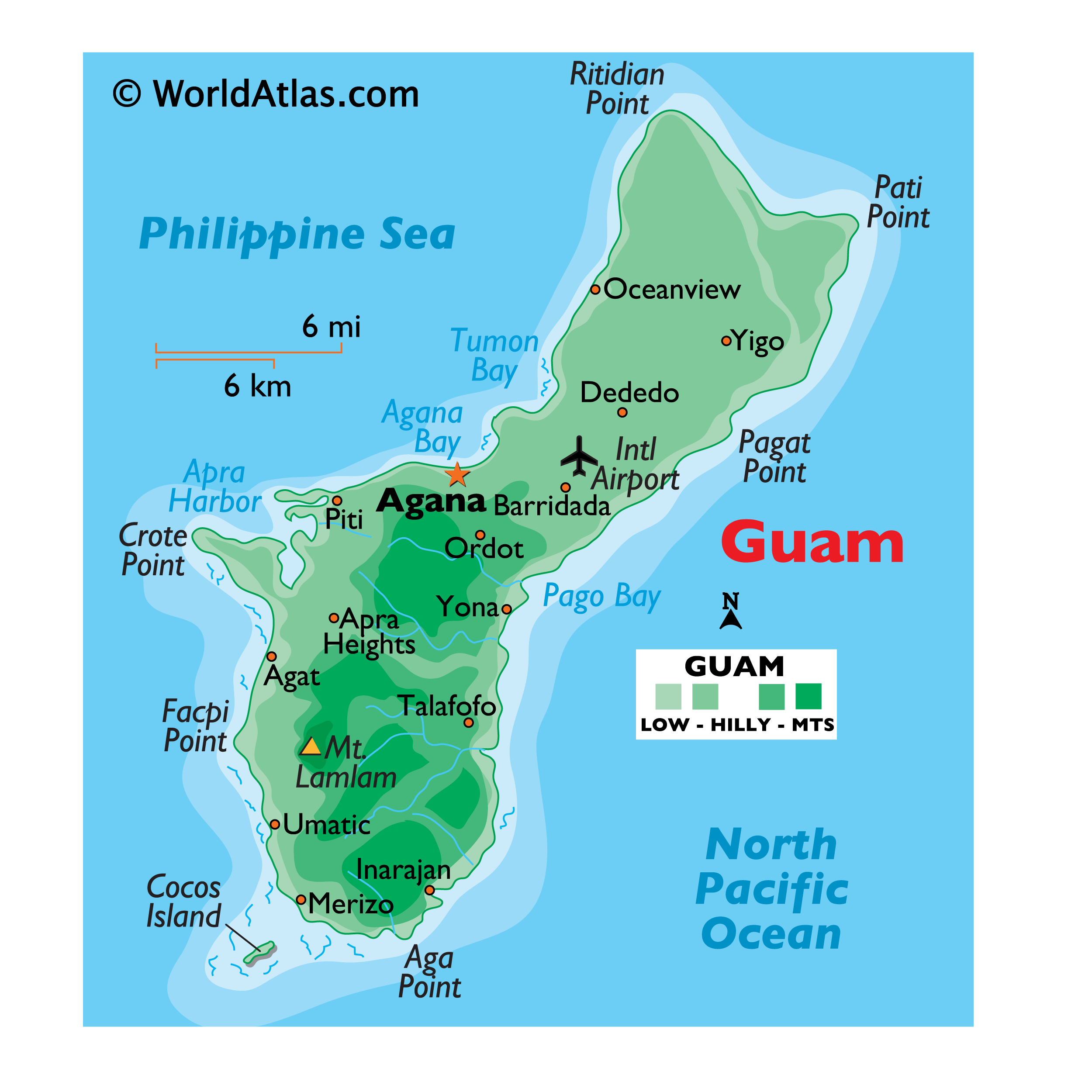
Covering an area of 540 sq.km (210 sq mi), Guam is an organized unincorporated territory of the United States in Micronesia; and the southernmost and largest island in the Mariana Island chain, located in the western North Pacific Ocean. The island is volcanic in origin, and ringed by steep coastal cliffs and sandy beaches.
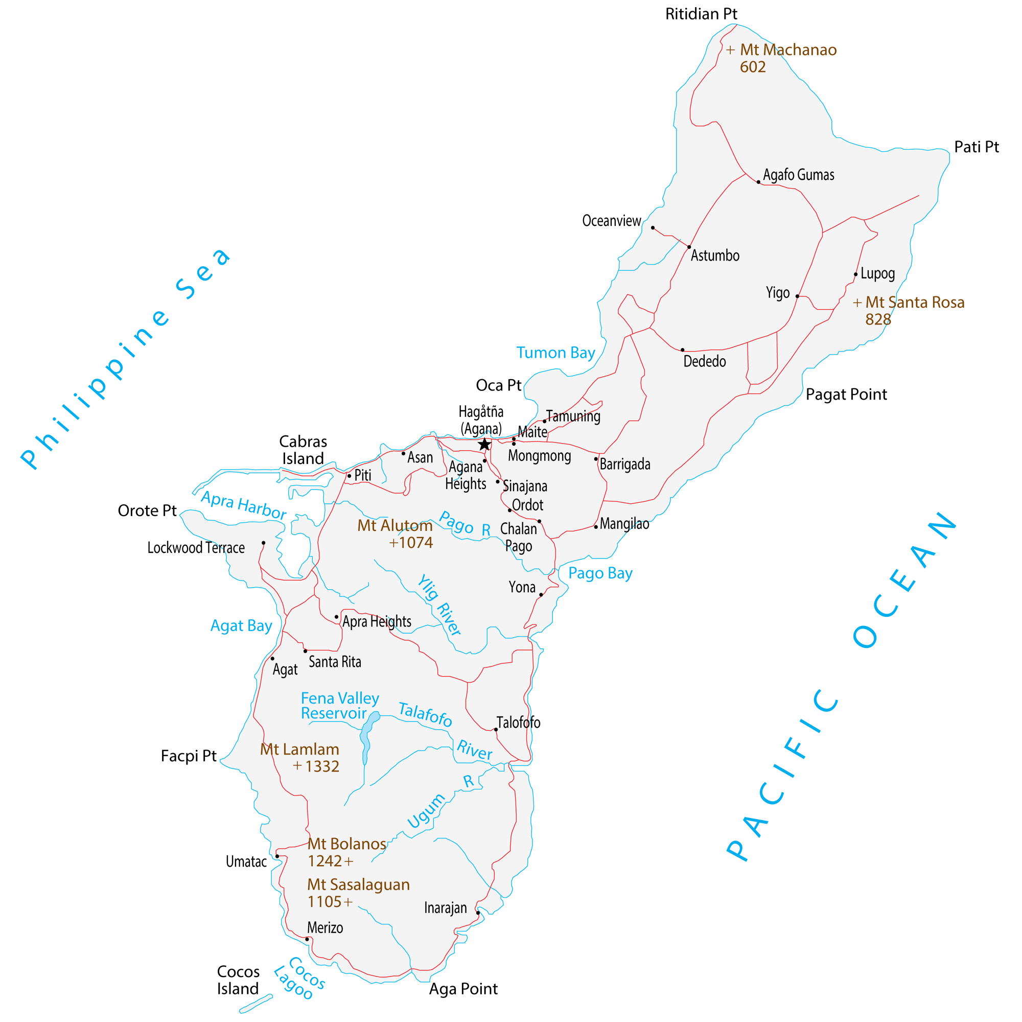
As observed on the physical map of Guam, mountains are primarily located on the southern end of Guam, with the northern region of the island sloping into low hills. Presence of a northern limestone plateau with a general elevation of 500ft (150m). the plateau is covered with a thick growth of jungle.
Deepwater channels and a coral table reef are located along much of the coast. The highest point is Mount Lamlam at an elevation of 1,338ft (408m) located in the southwest part of the island and marked on the map by a yellow triangle, and the lowest point is the North Pacific Ocean (0m).
| Flag: |  |
|---|---|
| Legal Name: | Guam |
| Capital Value: | Hagatna (Agana) |
| Official languages: |
|
| Demonym(s): | Guamanian |
| Government: | Devolved presidential constitutional dependency within a Federal republic |
| Legislature: | Legislature of Guam |
| Total Area: | 544 km² |
| Land Area: | 544 km² |
| Population: | 167,294 |
| Density: | 299/km (774.4/sq mi) |
| GDP: | $5.92 Billion |
| GDP Per Capita: | $35,712.56 |
| Currency Value: | US Dollar (USD) |
| Driving side: | right |
| Calling code: | +1-671 |
| Internet TLD: | .gu |
You can use our map of Guam for educational and commercial purposes with attribution required. To find out more about attributing our work, please visit our page on How to Cite.
Online Interactive Political Map
Click on ![]() to view map in "full screen" mode.
to view map in "full screen" mode.
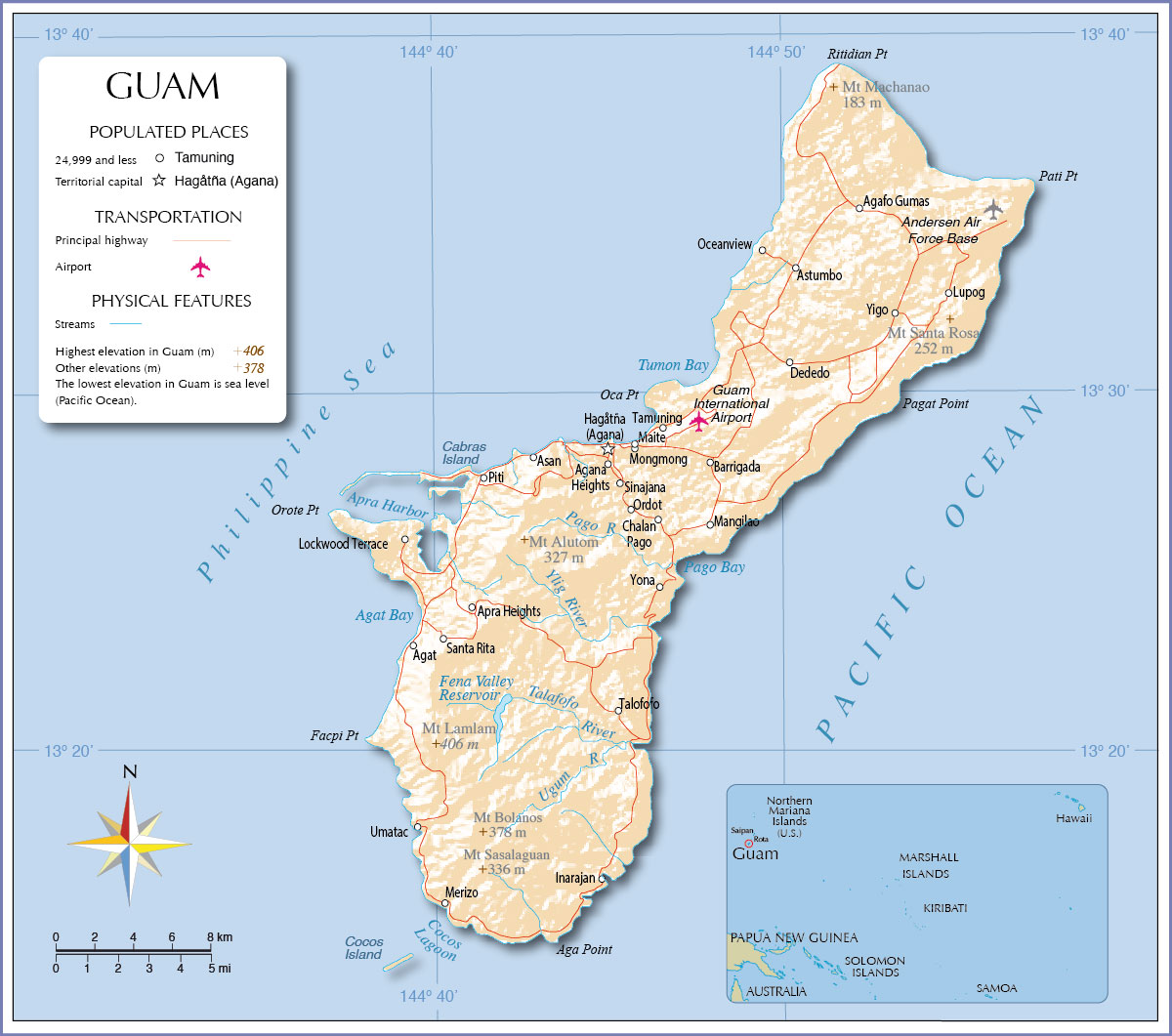
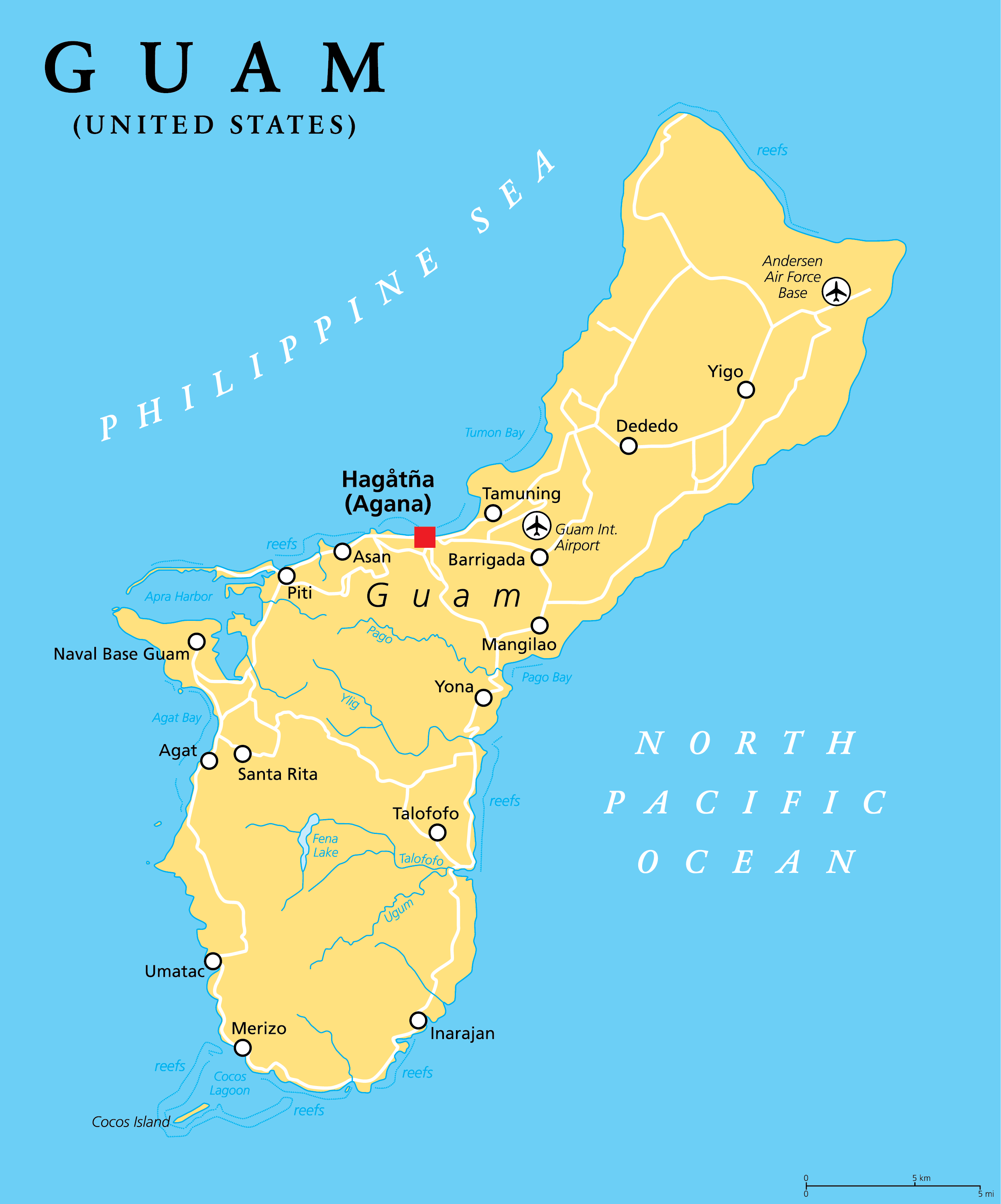
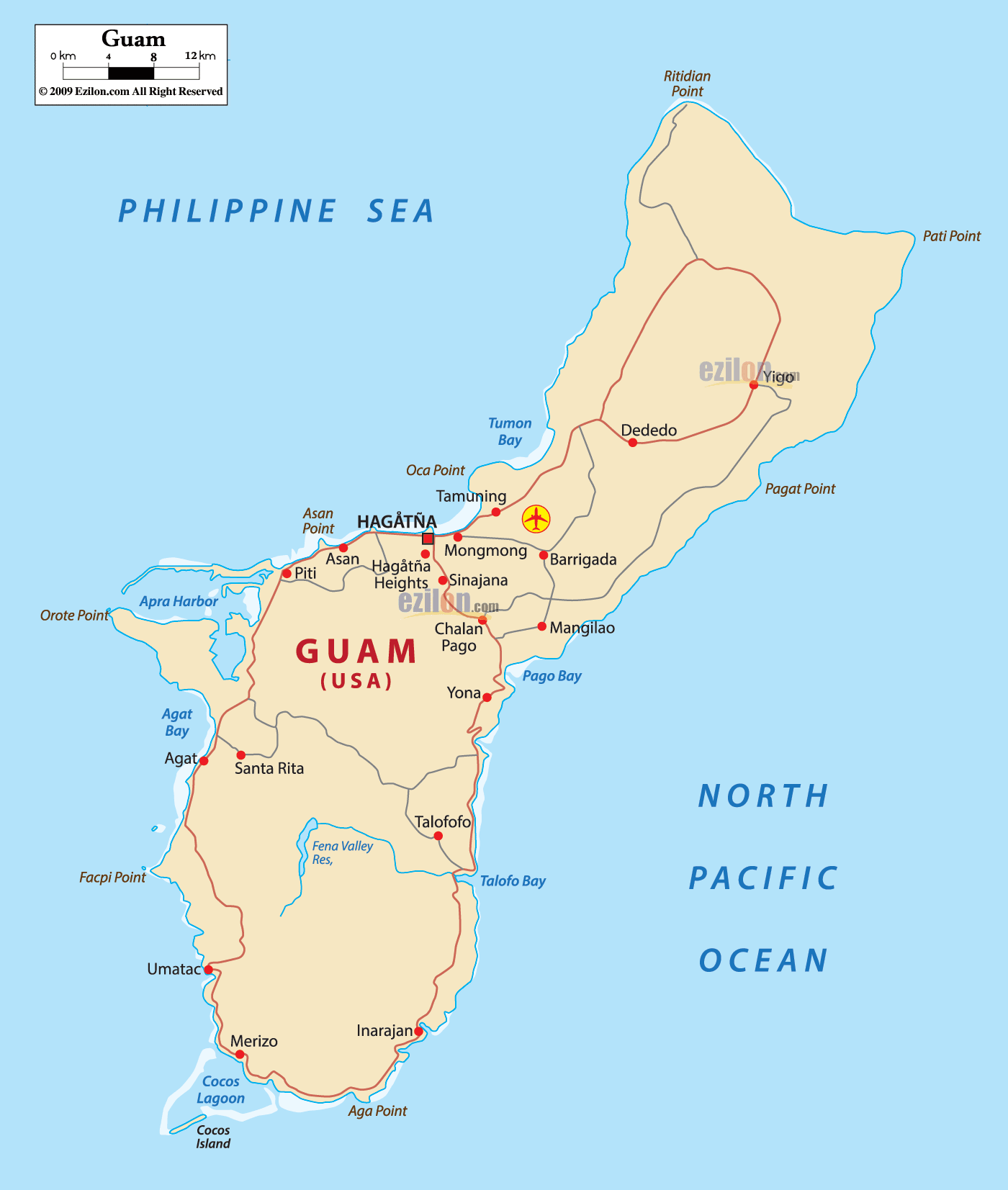
Guam (officially, the U.S. Territory of Guam) is divided into 19 villages. In alphabetical order, the villages are: Agana Heights, Agat, Asan, Barrigada, Chalan Pago-Ordot, Dededo, Hagatna, Inarajan, Mangilao, Merizo, Mongmong-Toto-Maite, Piti, Santa Rita, Sinajana, Talafofo, Tamuning, Umatac, Yigo and Yona.
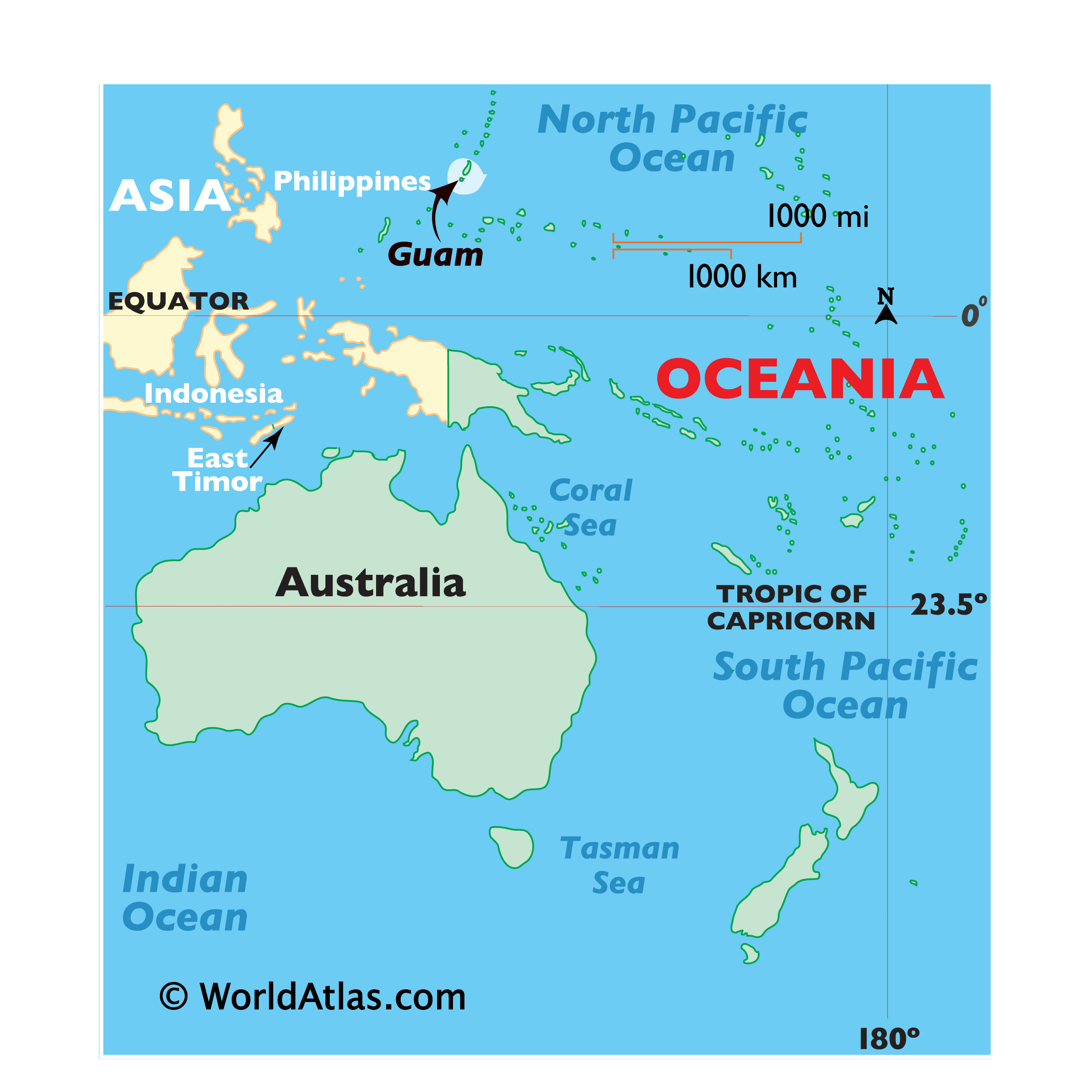
Covering an area of 540 sq.km, Guam is an organized unincorporated territory of the United States in Micronesia, located in the Western North Pacific Ocean. Guam is the westernmost territory of the United States and the largest territory in Oceania. The island territory is a part of the Mariana Islands archipelago, being the southernmost of the Mariana Islands and the largest Island in Micronesia.
Located on the western coast of Guam at the mouth of the Hagatna River is, Hagatna – the capital village of Guam. Hagatna hosts the arms of the Government and its commercial districts. Situated on the coral plateau in the north-central part of Guam is, Dededo – the largest and the most populous village in Guam.
Location Maps
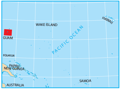
Where is Guam?
Guam Map
This Guam map displays cities, towns, roads, lakes, rivers, capes, and mountain peaks. Located in Micronesia in the Western Pacific Ocean near the Philippines Sea, Guam is an island territory of the United States. It is split into two distinct geographic regions; the north is a limestone plateau and the south is a rugged volcanic highland, with the highest peak being Mount Lamlam. Guam has a total area of 544 square kilometers and a large military presence as about ¼ of the territory is owned by the US Navy and Air Force. The Chamorro people are the indigenous people from Guam with their own language and set of customs still recognized today.

High Definition Political Map of Guam
History
Pre-Contact era
Guam, along with the Mariana Islands, were the first islands settled by humans in Remote Oceania. It was also the first and the longest of the ocean-crossing voyages of the Austronesian peoples, and is separate from the later Polynesian settlement of the rest of Remote Oceania. They were first settled around 1500 to 1400 BC, by migrants departing from the Philippines. This was followed by a second migration from the Caroline Islands in the first millennium AD. A third migration wave took place from Island Southeast Asia, likely the Philippines or eastern Indonesia, by 900 AD.
These original settlers of Guam and the Northern Mariana Islands evolved into the Chamoru people, historically known as Chamorros after first contact with the Spaniards. The ancient Chamoru society had four classes: chamorri (chiefs), matua (upper class), achaot (middle class), and mana’chang (lower class). The matua were located in the coastal villages, which meant they had the best access to fishing grounds. The mana’chang were located in the island’s interior. Matua and mana’chang rarely communicated with each other. The matua often used achaot as intermediaries.
There were also “makåhna” or “kakahna”, shamans with magical powers and “‘suruhånu” or “suruhåna”, healers who used different kinds of plants and natural materials to make medicine. Belief in spirits of ancient Chamorus called “Taotao mo’na” still persists as a remnant of pre-European culture. It is believed that “suruhånu” or “suruhåna” are the only ones who can safely harvest plants and other natural materials from their homes or “hålomtåno” without incurring the wrath of the “Taotao mo’na.” Their society was organized along matrilineal clans.
The Chamoru people raised colonnades of megalithic capped pillars called latte stones upon which they built their homes. Latte stones are stone pillars that are found only in the Mariana Islands. They are a recent development in Pre-Contact Chamoru society. The latte-stone was used as a foundation on which thatched huts were built. Latte stones consist of a base shaped from limestone called the haligi and with a capstone, or tåsa, made either from a large brain coral or limestone, placed on top. A possible source for these stones, the Rota Latte Stone Quarry, was discovered in 1925 on Rota.
Spanish era
The first European to travel to Guam was Portuguese navigator Ferdinand Magellan, sailing for the King of Spain, when he sighted the island on March 6, 1521, during his fleet’s circumnavigation of the globe. Despite Magellan’s visit, Guam was not officially claimed by Spain until January 26, 1565, by Miguel López de Legazpi. From 1565 to 1815, Guam and the Northern Mariana Islands, the only Spanish outposts in the Pacific Ocean east of the Philippines, were reprovisioning stops for the Manila galleons, a fleet that covered the Pacific trade route between Acapulco and Manila.
Spanish colonization commenced on June 15, 1668, with the arrival of a mission led by Diego Luis de San Vitores, who established the first Catholic church. The islands were part of the Spanish East Indies, and part of the Viceroyalty of New Spain, based in Mexico City. The Spanish-Chamorro Wars on Guam began in 1670 over growing tensions with the Jesuit mission, with the last large-scale uprising in 1683.
Intermittent warfare, plus the typhoons of 1671 and 1693, and in particular the smallpox epidemic of 1688, reduced the Chamoru population from 50,000 to 10,000, and finally to less than 5,000. Up until the late 19th century, Guam was encountered by adventurers and pirates, including Thomas Cavendish, Olivier van Noort, John Eaton, William Dampier, Woodes Rogers, John Clipperton, George Shelvocke and William “Bully” Hayes.
The island became a rest stop for whalers starting in 1823. A devastating typhoon struck the island on August 10, 1848, followed by a severe earthquake on January 25, 1849, which resulted in many refugees from the Caroline Islands, victims of a resultant tsunami. After a smallpox epidemic killed 3,644 Guamanians in 1856, Carolinians and Japanese were permitted to settle in the Marianas.
American era
After almost four centuries as part of the Kingdom of Spain, the United States occupied the island following Spain’s defeat in the 1898 Spanish–American War, as part of the Treaty of Paris of 1898. Guam was transferred to the United States Navy control on December 23, 1898, by Executive Order 108-A from 25th President William McKinley.
Guam was a station for American merchants and warships traveling to and from the Philippines, which was another American acquisition from Spain, while the Northern Mariana Islands were sold by Spain to Germany for part of its rapidly expanding German Empire. A U.S. Navy yard was established at Piti in 1899. A United States Marine Corps barracks was established at Sumay in 1901.
A marine seaplane unit was stationed in Sumay from 1921 to 1930, the first in the Pacific. The Commercial Pacific Cable Company built a telegraph/telephone station in 1903 for the first trans-Pacific communications cable, followed by Pan American World Airways establishing a seaplane base at Sumay for its trans-Pacific China Clipper route.
On 10 December 1914 the SMS Cormoran or SMS Cormoran II a German armed merchant raider was forced to seek port at Apra Harbor on the U.S. territory of Guam after running short on coal. The United States, which was neutral at the time refused to supply provisions sufficient for the Cormoran to make a German port so the ship and her crew were interned until 1917.
On the morning of April 7, 1917 word reached Guam by telegraph cable that the U.S. Congress had declared war on Germany. The Naval Governor of Guam, Roy Campbell Smith, sent two officers to inform the Cormoran that a state of war existed between the two countries, that the crew were now prisoners of war, and that the ship must be surrendered. Meanwhile, the USS Supply blocked the entrance to Apra Harbor to prevent any attempt to flee. In a separate boat, the two officers were accompanied by a barge commanded by Lt. W.A. Hall, who was designated prize master, and had brought 18 sailors and 15 Marines from the barracks at Sumay.
Seeing a launch from Cormoran hauling a barge of supplies back shore, Hall ordered shots fired across the bow of the launch until it hove to. Meanwhile, the two officers reached Cormoran and informed Captain Adalbert Zuckschwerdt of the situation. Zuckschwerdt agreed to surrender his crew but refused to turn over the ship. The U.S. officers informed Zuckschwerdt that the Cormoran would be treated as an enemy combatant and left to inform Governor Smith of the situation. Unbeknownst to the Americans, the Germans had secreted an explosive device in the ship’s coal bunker. Minutes after the Americans left, an explosion aboard Cormoran hurled debris across the harbor and her crew began abandoning ship. The two American boats and USS Supply immediately began to recover German sailors from the water, saving all but seven of the roughly 370 Cormoran crew. This incident, including the warning shots against the launch, accounted for the first violent action of the United States in World War I, first shots fired by the U.S. against Germany in World War I, the first German prisoners of war captured by the U.S., and the first Germans killed in action by the U.S. in World War I.
During World War II, the Empire of Japan attacked and invaded in the 1941 Battle of Guam on December 8, at the same time as the attack on Pearl Harbor. The Japanese renamed Guam Ōmiya-jima (Great Shrine Island). The Japanese occupation of Guam lasted about 31 months. During this period, the indigenous people of Guam were subjected to forced labor, family separation, incarceration, execution, concentration camps, and forced prostitution.
Approximately 1,000 people died during the occupation, according to later US Congressional committee testimony in 2004. Some historians estimate that war violence killed 10% of Guam’s then 20,000 population. The United States returned and fought the 1944 Battle of Guam from July 21 to August 10, to recapture the island. July 21 is now a territorial holiday, Liberation Day.
After World War II, the Guam Organic Act of 1950 established Guam as an unincorporated organized territory of the United States, provided for the structure of the island’s civilian government, and granted the people U.S. citizenship. The Governor of Guam was federally appointed until 1968 when the Guam Elective Governor Act provided for the office’s popular election. Since Guam is not a U.S. state, U.S. citizens residing on Guam are not allowed to vote for president and their congressional representative is a non-voting member.
They do, however, vote for party delegates in presidential primaries. In 1969, a referendum on unification with the Northern Mariana Islands was held and rejected. During the 1970s, Dr. Maryly Van Leer Peck started an engineering program, expanded University of Guam, and founded Guam Community College. In the same period, Alby Mangels, Australian adventurer and filmmaker of World Safari visited Guam during his six-year escapade on the leg of his voyage through the Pacific aboard the Klaraborg.
The removal of Guam’s security clearance by President John F. Kennedy in 1963 allowed for the development of a tourism industry. When the United States closed U.S. Naval Base Subic Bay and Clark Air Base bases in the Philippines after the expiration of their leases in the early 1990s, many of the forces stationed there were relocated to Guam.
The 1997 Asian financial crisis, which hit Japan particularly hard, severely affected Guam’s tourism industry. Military cutbacks in the 1990s also disrupted the island’s economy. Economic recovery was further hampered by devastation from Supertyphoons Paka in 1997 and Pongsona in 2002, as well as the effects of the September 11 terrorist attacks on tourism.
Physical Map of Guam